WAMSI Bulletin June 2018
Marine science focus turns to Perth metro and south coast
This article was originally published on an archived WAMSI website. Some media or links may appear missing or broken. You can use the search function to look for these, or contact info@wamsi.org.au for a specific request.
—
The Perth metro and southern coastlines are among the next areas of focus for research development by the Western Australian Marine Science Institution partnership.
Having successfully executed one of the largest single-issue research projects in Australia on dredging science and another in the Kimberley, the Western Australian Marine Science Institution (WAMSI) has determined five key areas to address in the next step to delivering the science priorities outlined in the WA Blueprint for Marine Science.
WAMSI Chief Executive Officer Dr Luke Twomey said the WAMSI Board, including representatives from universities, CSIRO, The Australian Institute of Marine Science and government, had supported the decision to work on determining the science required to meet the community, industry and infrastructure needs off the Perth metro and southern coastlines; the Shark Bay World Heritage site; decommissioning; and marine science information management.
“There is a variety of new and existing pressures along the Perth metropolitan coastline including the Westport port and environs strategy, the Defence expansion at Garden Island and ongoing industry and infrastructure needs aligned with coastal development,” Dr Twomey said. “We need to take a holistic view of how we use that marine environment and determine what science will be required to help us make better decisions.”
The WAMSI joint venture partnership consisting of 15 industry, government and academic institutions also identified gaps in understanding about the south coast that needed to be fed back into state and federal marine park planning.
“More recently the southern coastline has become a hub for The University of Western Australia led Wave Energy Research Centre, developing aquaculture and ecotourism industries, as well as ongoing interest in offshore development,” Dr Twomey said. “The time has come where we need to really discuss these research gaps with all those involved, including the Indigenous community, so we can ensure that science and investment is targeted.”
Work is already underway to develop the science priorities for the Shark Bay World Heritage Site, with more than 70 representatives from research institutions, industry and government coming together recently in a workshop that is being developed into a white paper.
WAMSI is also working with the two peak oil and gas industry advisory bodies, Australian Petroleum Production and Exploration Association and National Energy Resources Australia, to help develop the questions and plans to meet the science priorities that emerged from the WAMSI review of stakeholder views on decommissioning offshore infrastructure.
Laying the groundwork for developing a system for marine science information management has also been identified as an immediate priority to support the blue economy into the future.
“It’s about getting as much data as we can and extracting as much value out of it as possible” Dr Twomey said. “We need to develop a way to bring together current monitoring data and make it more widely accessible.”
“We’ve been working with the Western Australian Biodiversity Science Institute on developing a roadmap to obtain data from environmental impact assessments, research institutions, marine industries and marine park management and we’ll continue to develop that.”
The Western Australian government has committed more than $2.6 million over three years to support the implementation of the Blueprint for Marine Science, which will guide long-term collaboration between all sectors operating in the marine environment and establish a hub for global marine research.
Adapting to ecosystem change in the Shark Bay World Heritage Site
Five years after a report into the Shark Bay World Heritage site recommended a coordinated collaborative approach was vital to understand changes in the ecosystem, more than 70 science and industry experts have joined forces to examine the threats and prioritise the research needed to save its status.
Shark Bay, located midway along the coast of Western Australia, occupies about 2.2 million hectares of marine and terrestrial reserves, featuring more than 30 islands, the largest (4,800 km2) and richest segrass beds in the world, five species of endangered mammals, as well as stromatolites. It is one of only 30 places on the World Heritage List of 1073, to satisfy all four natural criteria including:
To contain the most important and significant natural habitats for in-situ conservation of biological diversity, including those containing threatened species of outstanding universal value from the point of view of science or conservation.
A federal Governmnent report in 2009 titled the Implications of climate change for Australia’s World Heritage properties: a preliminary assessment, highlighted the uncertainties for Shark Bay created by the effect of climate change on the Leeuwin Current. Among its predictions was that increased sea temperatures could see tropical marine life move south and a greater likelihood of predation in the area by tiger sharks.
A marine heatwave in 2011 is now know to have caused a 20 per cent loss of seagrass habitat, equivalent to a loss of 1,000 km2 of meadows. Birth rates in dolphins dropped; crab, oyster and other fisheries were negatively affected. All this, while projected tourism numbers are fell well short of their mark.
In response, a workshop and resulting publication, focused on Shark Bay, recommended a coordinated multi-institutional and multi-discipline approach to research (Kendrick et al. 2012). However, five years on there is little evidence of such a coordinated approach to research.
This month, Professor Gary Kendrick from The University of Western Australia made another call to turn attention toward the potential demise of the unique World Heritage area and the response by more than 70 state, national and international experts was immediate.
“Given the changes that have already occurred and the scale of predicted further changes, a better understanding of the drivers of environmental changes on productivity is a critical step in being able to predict the ecological resilience of Shark Bay,” Professor Kendrick said. “We need to adopt appropriate management strategies to minimise the impacts of environmental variations on natural resources and the industries that depend on them.”
The expert workshop identified priority knowledge gaps and whether something could be done to address them. It assessed the importance of each gap by comparing the consequences of either ‘taking action’ to ‘doing nothing’.
 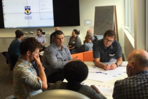 |
| More than 70 Shark Bay science, industry and community stakeholders break into groups to come up with science priorities. (WAMSI) |
“It was a great day of brainstorming,” Professor Kendrick said. “Overall, there was consensus on concern over the ecosystem changes in Shark Bay but there was no consensus on how to resolve it.”
Professor Kendrick is now working to collate the workshop responses and identify the top science priorities in a white paper to the state government.
 |
| The expert workshop ‘Adapting to ecosystem change in the Shark Bay World Heritage site’ identified concern over ecosystem change but no consensus on how to resolve it. UWA Professor Gary Kendrick will now identify the top priorities for science in a white paper. (WAMSI) |
Workshop presentations slides are available HERE
Study identifies water quality thresholds to protect fish during dredging

A global study has assessed the potential risk from dredging to coastal fish and fisheries and identified guidelines that could protect 95 per cent of fishes from dredging‐induced mortality.
Dredging operations worldwide are forecast to intensify in the future to meet the demands of an increasing rate of coastal development and shipping activities and up to 20 per cent of fish species are likely to experience lethal and sub-lethal impacts as a result, according to results published in Conservation Letters.
The Western Australian Marine Science Institution Dredging Science Node brought together a team of researchers from universities and management agencies in Australia, led by Dr. Amelia Wenger at the University of Queensland, to develop evidence-based management guidelines to protect fish and fisheries from impacts associated with dredging.
The study found that more than 2,000 ports worldwide are within the range of at least one threatened species, while 97 ports are located within the range of five or more threatened species.
 |
| Figure 1: The global overlap between coastal ports and threatened marine fishes. The map shows the spatial distribution of threatened species, with the colors denoting the number of threatened species within particular areas. The black crosses indicate the presence of a port. The graph indicates the number of ports that fall within the geographic range of one or more threatened species (Wenger et al.) |
It also determined that globally, between 2010 and 2014, 40.9 million tons of global commercial fisheries catch and 9.3 million tons of small-scale fisheries catch were extracted within five kilometres of a port, including many species known to be sensitive to sediment.
 |
| Figure 2: The spatial distribution and quantity of fishing activity that occurs within 5 km of a port. (a), (b) The location of commercial and small‐scale fishing activities and the quantity of catch in tons for each country where fishing activity occurs within 5 km of a port. (c) The countries where fishing of species known to be sensitive to sediment (see Table S3) occurs within 5 km of a port and the quantity of the catch. (d) The proportion of the fisheries catch of sediment‐sensitive species compared to the total fisheries catch that comes from within 5 km of a port for each country (Wenger et al.) |
Dr Wenger said fish larvae were most likely to be affected by dredging sediment but that there were measures that could be taken to markedly increase the survival rate.
“While adult fish are unlikely to experience lethal impacts during dredging activities, we found that fish during early life history stages are at risk to lethal and sublethal impacts at suspended sediment concentrations and exposure durations regularly occurring during dredging operations,” she said.
“We found that maintaining suspended sediment concentrations below 44 mg/L and for less than 24 hours would protect 95% of fishes from dredging‐induced mortality.
“Seasonal restrictions during peak periods of reproduction and recruitment could also protect species from dredging impacts,” Dr Wenger explained.
The thresholds developed in the study are considered to be a starting point for an adaptive management framework, to be used in conjunction with a monitoring program that evaluates the effectiveness of different management strategies at mitigating impacts to fish and fisheries.
Wenger A, Rawson C, Wilson S, Newman S, Travers M, Atkinson S, Browne N, Clarke D, Depczynski M, Erftemeijer P, Evans R, Hobbs JP, McIlwain J, McLean D, Saunders B, Harvey E (2018) Management strategies to minimize the dredging impacts of coastal development on fish and fisheries. Conservation Letters https://doi.org/10.1111/conl.12572
The WAMSI Dredging Science Node is made possible through $9.5 million invested by Woodside, Chevron and BHP as environmental offsets. A further $9.5 million has been co-invested by the WAMSI Joint Venture partners, adding significantly more value to this initial industry investment. The node is also supported through critical data provided by Chevron, Woodside and Rio Tinto Iron Ore.
Category:
Understanding the flow of suspended sediments across reefs
")
A new study has developed a model that moves researchers a step closer to improved predictions of changes in shorelines adjacent to coral reefs and the transport of suspended sediments in reef systems.
This study at Tantabiddi, Ningaloo Reef in the northwest of Western Australia, deployed more than 20 instruments to measure how waves transform over the reef and in the lagoon, how currents develop and circulate throughout the reef system as well as the concentration of sediment in suspension in different zones of the reef.
The results published in Journal of Geophysical Research reveal that although variability in suspended sediment concentration occurs at tidal (or shorter) timescales in the different reef zones, the majority of the variability occurs over longer slowly varying (subtidal) timescales, which is related to the arrival of large swell waves at a reef location.
|
|
| More than 20 instruments set up to measure suspended sediment flow at Tantabiddi, Ningaloo Reef (Image: Andrew Pomeroy) |

The study, supported by Western Australia Marine Science Institute (WAMSI) Dredging Science Node, the Australian Research Council and the U.S. Geological Survey Coastal and Marine Geology Program captured low and high wave conditions, as well as a period of strong alongshore transport driven by wind. Wave generated currents flowed across the reef, separated in the lagoon and exited via the channels in the reef.
Lead author Dr Andrew Pomeroy from The University of Western Australia and the Australian Institute of Marine Science explained that up to 95% of the variability in the concentration of suspended sediments can be described by variability in waves and currents at tidal and longer timescales.
“This study shows that in coral reefs, suspended sediment transport varies at a number of different timescales – for example by waves, tides or time periods longer than tides such as storm systems, and by different processes – which is most important will depend on the question being asked,” Dr Pomeroy said.
Dr Pomeroy says the emphasis now needs to be placed on understanding and describing the physical processes that suspend sediment from the bed within coral reef canopies. Data within coral canopies as well as close to the bed is lacking because it is difficult to accurately obtain.
“This is important as it will enable changes in shorelines adjacent to reefs (by erosion or accretion) to be described as well as improve predictions of suspended sediment transport in coral reef environments for a range of conditions,” he said.
Pomeroy A, Lowe R, Ghisalberti M, Winter G, Storlazzi C, Cuttler M (2018) Spatial variability of sediment transport processes over intra‐ and subtidal timescales within a fringing coral reef system. Journal of Geophysical Research doi.org/10.1002/2017JF004468
The WAMSI Dredging Science Node is made possible through $9.5 million invested by Woodside, Chevron and BHP as environmental offsets. A further $9.5 million has been co-invested by the WAMSI Joint Venture partners, adding significantly more value to this initial industry investment. The node is also supported through critical data provided by Chevron, Woodside and Rio Tinto Iron Ore.
Category: