Tiny Microbes, Big Impact – One Ten East Log

One Ten East Logs from the IIOE-2 voyage aboard RV Investigator will be posted on the WAMSI website during the month long voyage.

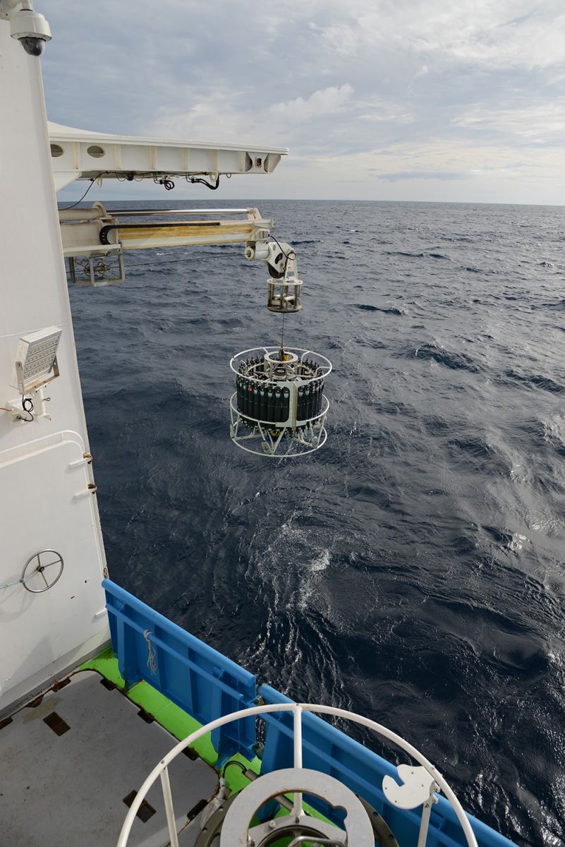
We have had another fantastic day in the Indian Ocean aboard RV Investigator. The CTD was deployed early in the morning and with a calm sea and light wind, the first station on the 110 East line was successfully completed. Micro and macro zooplankton have been collected with various nets, the CTD rosette was lowered twice and from those water samples, nutrients and microbes have been sampled for analysis.

We even had a minke whale sighted not too far from the ship and then two fin whales passed the starboard side and then across the bow! We have plankton and whales, life is good!

Log from One Ten East

The RV Investigator is currently undertaking oceanographic research along the 110°E meridian off Western Australia as part of the second International Indian Ocean Expedition. The voyage is led by Professor Lynnath Beckley of Murdoch University and the research is supported by a grant of sea time on RV Investigator from the CSIRO Marine National Facility.

Date: May 18, 2019 Time:  1200 AWST
Latitude: 38°S Longitude: 110°E
Wind direction: N Wind speed:  15 knots
Swell direction: SW Depth:  4266 m
Air temperature: 13.7°C Sea temperature: 13.8°C

Notes: Station 1 is done and dusted. It was a very busy day with lots of samples and data collected by many satisfied scientists.

Tiny Microbes, Big Impact

By Dr Martin Ostrowski

Microbes are everywhere, they’re in the soil, on our skin, in our guts and they live in the ocean in incredible numbers. In a similar role to our gut microbes, which are keeping us healthy, research has revealed that ocean microbes play important roles sustaining our planet. What are these microbes and what are they doing? Onboard RV Investigator a team of microbiologists is addressing these questions using modern molecular methods. They aim to identify which microbes are present and determine how they thrive and interact with other species. This work will help us understand how these tiny organisms support the production of food in the ocean, which feeds over 1 billion people, and ultimately plays a fundamental role keeping our planet healthy.

Most marine microbes are planktonic, but surprisingly, they fundamentally shape their surroundings by transforming over 90% of all organic matter, driving major elemental and geochemical cycles, and making and breaking chemical compounds that have a direct effect on climate. What they lack in size, they make up for in sheer numbers.

The activity of microbes impacts on all levels of the marine systems, from water chemistry and primary production, which ultimately supports all marine life, through to regulating climate and playing a role in the health of the largest mammals on the planet. Over geological time, free-living marine microbes have been the main source of power for the planet. By modern estimates, approximately half of all primary production occurs in the oceans. In very general terms, this means that marine microbes are like the lungs of the planet, but in reverse, drawing in carbon dioxide and releasing oxygen for us to breathe.

Microbes are invisible to the naked eye, especially the single-celled species, which make up the bulk of ‘biomass’ in the oceans. Much of the work done in the microbiology lab involves flow cytometry and high-throughput genome sequencing of water samples collected from different depths using the CTD rosette of Niskin bottles. We use the cytometer to count different types of bacteria, cyanobacteria, micro algae and virus particles. There are more than one million microbial cells in each millilitre of seawater, and 10 times more viruses! Sequencing of microbial marker genes provides estimates of total diversity in the Australian marine microbiome.

Be sure to follow our daily Log from One Ten East at https://iioe-2.incois.gov.in or www.wamsi.org.au

Indian Ocean Nutrients – One Ten East Log

One Ten East Logs from the IIOE-2 voyage aboard RV Investigator will be posted on the WAMSI website during the month long voyage.

The wind and swell was up a little yesterday. This seemed to keep a few participants in their bunks a bit longer in the morning but by evening, most were feeling fine again. Fortunately, this was a transit day and the weather has improved as we have begun the first station on 110 East meridian. 

The yellow-nosed and black-browed Albatross were soaring beautifully in the fresh 20-30 kts and all is well on the fine RV Investigator.

Log from One Ten East

The RV Investigator is currently undertaking oceanographic research along the 110°E meridian off Western Australia as part of the second International Indian Ocean Expedition. The voyage is led by Professor Lynnath Beckley of Murdoch University and the research is supported by a grant of sea time on RV Investigator from the CSIRO Marine National Facility.

Date:  May 17, 2019 Time:  1200 AWST
Latitude: 39.5°S Longitude: 110°E
Wind direction: NNW Wind speed: 10 knots
Swell direction: SSW Depth: 4600 m
Air temperature: 9.6°C Sea temperature: 12.6°C

Notes: Five species of albatrosses, cape petrels and a minke whale sighted today. The galley is providing wonderful food for a hungry and appreciative crew!

Indian Ocean Nutrients

By Dr Peter Thompson

The CSIRO scientists involved in the original International Indian Ocean Expedition during the 1960s described it as a desert. Huge regions of the Indian Ocean had almost no plant life. The thousands of species and billions of microscopic plants found in most oceans were largely absent. These plants, just like the ones in your garden or paddock, require nutrients to grow. In the garden, we add fertiliser with these nutrients, particularly nitrogen and phosphorus, to ensure a successful crop. These nutrients are in very short supply in the surface waters of the Indian Ocean.

To find out how much nutrient is present it is necessary to get samples of water from deep in the ocean. Special tubular containers, called Niskin bottles, located on the CTD are sent down with the ends open (can you guess why?) on a wire to depths of 5000 m where they are electronically triggered to close and collect the samples. Several hours later when the bottles are winched back to the surface the chemists can start the process of measuring the nutrients. To do this we use sophisticated on board instruments and internationally agreed high precision methods. It is a bit like a blood test to check the health of the ocean.

In the nearly 60 years since the first International Indian Ocean Expedition we have learned much about the cycling of nutrients in the ocean. A thousand meters below the surface where the water is only 5°C, nitrate is plentiful (Figure 1). However, enough light for plants to grow only penetrates to about 100 m where nitrate is particularly scarce. Processes that we did not understand in the 1960s, we now know are changing the supply of nutrients to the surface and some parts of the Indian Ocean are becoming more productive (more nutrients = more plants = more fish) while others are less productive. On this second voyage (IIOE-2) we are exploring how nutrient supply has changed over the last six decades in the Indian Ocean offshore of Western Australia.

In particular, we are looking for evidence of changes in nutrients within the deep ocean as a result of changing global ocean circulation patterns. This mix of deep and shallow circulation brings deep nutrients from the North Atlantic and some nutrients from the Pacific into the Indian Ocean (Figure 2).

These processes are changing faster than ever due to global warming. In addition, we will investigate nutrient recycling near the surface of the ocean. There, an expanding area of low oxygen is impacting on the microbial processes that recycle organic matter. Understanding the impacts of these changes on the ecology of the Indian Ocean is one of the key goals of the 110° East voyage.

Be sure to follow our daily Log from One Ten East at https://iioe-2.incois.gov.in or www.wamsi.org.au

Taking the Pulse of the Ocean with the CTD – One Ten East log

One Ten East Logs from the IIOE-2 voyage aboard RV Investigator will be posted on the WAMSI website during the month long voyage.


Log from One Ten East

The RV Investigator is currently undertaking oceanographic research along the 110°E meridian off Western Australia as part of the second International Indian Ocean Expedition. The voyage is led by Professor Lynnath Beckley of Murdoch University and the research is supported by a grant of sea time on RV Investigator from the CSIRO Marine National Facility.


Date: May 16, 2019

Time: 1200 AWST

Latitude: 37.143° S

Longitude: 111.712° E

Wind direction: 182° (S)         

Wind speed: 22 knots

Swell direction: SE, S

Depth: 5,176 m

Air temperature: 11.5°C

Sea temperature: 16.0°C

Notes: Ship steaming to the first station of the 110°East line, albatrosses soaring and Antarctic and pygmy blue whales calling.


By Helen Phillips

The most reliable way we have to track global warming is by measuring the change in temperature in the ocean. This is because the ocean is absorbing more than 90% of the extra heat. Most of the global warming heat is in the upper 1000 m of the ocean. However, around Antarctica, the surface waters become saltier and heavier as sea ice forms in winter, and they sink all the way to the bottom of the ocean. These Antarctic Bottom Waters spread northward filling the deepest parts of the ocean, including the Indian Ocean, contributing to sea level rise as they warm.

The best way to measure the deep ocean below 2000 m is using a CTD–a Conductivity, Temperature and Depth profiler, lowered from a research vessel. The electronic sensors of the CTD are positioned within a large frame (the rosette) around which are 36 12-litre bottles that are used to capture water at different depths. This water is extremely valuable to the scientists on board as direct chemical analysis in our laboratory is the primary way to measure some water properties and also provides a critical check on the accuracy of the electronic measurements. Biological studies also need actual samples of water to identify tiny microbes in the water. This labour-intensive, costly work means that measurements in the deep ocean are infrequent and sparsely distributed.

The CTD rosette contains 36 Niskin bottles, which are sent down into the water column open at both ends and are remotely closed at specific depths, allowing for sampling of various levels in the ocean. Photo: Micheline Jenner.


On the first International Indian Ocean Expedition in the 1960s, the CTD was not yet invented, but bottles could be lowered to collect water samples at specific depths, and a reversing thermometer was used to record the temperature at depth. So there are measurements of the properties of the bottom waters from the 1960s. Sixty years later, our new measurements will reveal how rapidly the changes already detected around Antarctica have progressed into the Indian Ocean, and will help to guide our predictions of future warming and sea level rise. In addition to bottom water changes, we will be able to measure changes at all levels, not only in temperature but in the chemical composition and biological diversity, as well.

Dr Helen Phillips from IMAS, University of Tasmania is processing data collected from the CTD. Photo: Micheline Jenner.


Be sure to follow the daily posts of the Log from One Ten East on the IIOE-2 voyage at https://iioe-2.incois.gov.in and www.wamsi.org.au


Taking the Pulse of the Ocean with the CTD – One Ten East log 16 May 2019

One Ten East Logs from the IIOE-2 voyage aboard RV Investigator will be posted on the WAMSI website during the month long voyage.

Log from One Ten East

The RV Investigator is currently undertaking oceanographic research along the 110°E meridian off Western Australia as part of the second International Indian Ocean Expedition. The voyage is led by Professor Lynnath Beckley of Murdoch University and the research is supported by a grant of sea time on RV Investigator from the CSIRO Marine National Facility.

Date: May 16, 2019 Time: 1200 AWST
Latitude: 37.143° S Longitude: 111.712° E
Wind direction: 182° (S) Wind speed: 22 knots
Swell direction: SE, S Depth: 5,176 m
Air temperature: 11.5°C Sea temperature: 16.0°C

Notes: Ship steaming to the first station of the 110°East line, albatrosses soaring and Antarctic and pygmy blue whales calling.

By Helen Phillips

The most reliable way we have to track global warming is by measuring the change in temperature in the ocean. This is because the ocean is absorbing more than 90% of the extra heat. Most of the global warming heat is in the upper 1000 m of the ocean. However, around Antarctica, the surface waters become saltier and heavier as sea ice forms in winter, and they sink all the way to the bottom of the ocean. These Antarctic Bottom Waters spread northward filling the deepest parts of the ocean, including the Indian Ocean, contributing to sea level rise as they warm.

The best way to measure the deep ocean below 2000 m is using a CTD–a Conductivity, Temperature and Depth profiler, lowered from a research vessel. The electronic sensors of the CTD are positioned within a large frame (the rosette) around which are 36 12-litre bottles that are used to capture water at different depths. This water is extremely valuable to the scientists on board as direct chemical analysis in our laboratory is the primary way to measure some water properties and also provides a critical check on the accuracy of the electronic measurements. Biological studies also need actual samples of water to identify tiny microbes in the water. This labour-intensive, costly work means that measurements in the deep ocean are infrequent and sparsely distributed.

On the first International Indian Ocean Expedition in the 1960s, the CTD was not yet invented, but bottles could be lowered to collect water samples at specific depths, and a reversing thermometer was used to record the temperature at depth. So there are measurements of the properties of the bottom waters from the 1960s. Sixty years later, our new measurements will reveal how rapidly the changes already detected around Antarctica have progressed into the Indian Ocean, and will help to guide our predictions of future warming and sea level rise. In addition to bottom water changes, we will be able to measure changes at all levels, not only in temperature but in the chemical composition and biological diversity, as well.

Be sure to follow our daily Log from One Ten East at https://iioe-2.incois.gov.in or www.wamsi.org.au

WAMSI Bulletin May 2019

WAMSI surveys Shark Bay values

A research team, surveying values that are important to the people of Shark Bay, is finding a variety of views are attached to the World Heritage area famous for its marine life and ancient stromatolites, with an economy that largely relies on the success of tourism and fishing industries.

More than 30 members of the community were surveyed last week in this first round of interviews  including representatives from local and state government, fishing and tourism business owners, long-term residents and Indigenous rangers.

The Western Australian Marine Science Institution (WAMSI) will continue to conduct interviews over the coming weeks to determine the values, issues and concerns.

WAMSI Research Director Dr Jenny Shaw said initial indications were that there is a broad range of views across Shark Bay.

“Values held by the people of Shark Bay were varied but some common themes have begun to emerge,” Dr Shaw said.  “There was widespread awareness of the massive seagrass loss from the 2011 marine heatwave and concerns about how that might have affected any changes in the bay. Tourism and fishing were also common themes.

“What we’ll do first is collect the research that’s already been done to look at whether some of the answers can be found in those bodies of work.

“Once we’ve brought together all the existing research, we can identify where there might be gaps in knowledge that relate to the values we’ve identified in our interviews. We’ll then develop a comprehensive science plan for Shark Bay to address those gaps.

“It’s a large and complex strategy to develop a comprehensive plan to respond to environmental pressures facing Shark Bay but it’s an important exercise to complete, especially now with increasing tourism,” Dr Shaw said.

The RAC Monkey Mia Resort recently doubled its capacity from around 600 to 1200 guests per night. It’s estimated that the resort accommodates less than one third of the total number of visitors who enter the national park to see the dolphins.

This week’s Fishing Fiesta will see the return of some 100 recreational fishers and their families to the town of Denham.

Bag limits for some fish species in Shark Bay are higher than tourist destinations further south, making the region an attractive option for recreational fishers throughout the year.

The Shark Bay Stakeholder Values report and gap analysis is expected to be completed by the end of the year.

Testing, Testing, 1,2,3! – One Ten East log

One Ten East Logs from the IIOE-2 voyage aboard RV Investigator are being posted on the WAMSI website during the month long voyage.

By Prof Lynnath Beckley

The RV Investigator departed Fremantle yesterday afternoon after loading equipment and supplies for our month-long voyage as part of the second International Indian Ocean Expedition. Everyone is finding their sea legs and adapting to the 24/7, 12 hours on and 12 hours off watch system.

Today, as we traverse the 1000 km towards our first station on 110°E, we stopped to do some equipment testing and personnel training so that everyone could become familiar with the equipment, procedures and safety involved with oceanographic sampling.

We are currently about 120 km west of Cape Leeuwin, one of the world’s “Great Capes”. Remarkably, at Cape Leeuwin there is a plaque commemorating the fact that on 6th December 1801, Captain Mathew Flinders, Commander of HMAS Investigator, sighted Cape Leeuwin and started mapping the Australian coast. Now, on the modern 93m RV Investigator, we are on our way to map the south-east Indian Ocean repeating an oceanographic voyage conducted way back in May and June 1963 by the HMAS Diamantina as part of the first International Indian Ocean Expedition.

“Lights, sound, camera, action” could well have been the call today as we started our testing. Prof David Antoine’s optics team from Curtin University got their many instruments designed to examine light in the ocean up and running. Likewise, using sonobuoys, Curt and Micheline Jenner are already busy monitoring sound from whales as part of their ongoing work for the Australian Department of Defence. Micheline is also our resident photographer and has been busy with her brace of cameras documenting the activities of our 40 scientists and technicians.

We also tested the CTD rosette which is a critical piece of equipment for all the researchers as we document the physical, chemical and biological properties of the water column. When it is brought back on board, it has over 400 L of water sampled from a range of depths in the ocean from which we can examine nutrients, microbes, genetics, pigments and get water to run a range of experiments such as primary production, nitrogen uptake and grazing by micro-zooplankton.

The zooplankton team were also busy testing their extensive arsenal of nets of various configurations and mesh sizes so that they can examine the poorly understood pelagic south-east Indian Ocean food web from tiny phytoplankton through to deep sea lantern fishes.

This research is supported by a grant of sea time on RV Investigator from the CSIRO Marine National Facility.

Be sure to follow the daily posts of our One Ten East Logs from the IN2019_V03 aboard RV Investigator at https://iioe-2.incois.gov.in and www.wamsi.org.au .

Lesson plans put WAMSI data in schools

Lesson plans taking data from real research projects are now online to provide students with the opportunity to develop their data science skills based on crocodile and whale surveys.

An initiative by Western Australian Marine Science Institution Data Manager Luke Edwards working with Kimberley Marine Research Program project leader Kelly Waples, Education Services Australia’s Richard Martin and Australian Data Science Education Institute’s Dr Linda McIver has produced a series of online educational resources on Western Australia’s Kimberley region.

It provides a resource for teachers to assist them to develop data science skills using engaging real-life datasets.  It also helps teachers deliver the new Digital Technologies curriculum and contributes to the Digital Technologies Hub resources.

“Having data resources available to teachers based on actual research results from the Western Australian marine environment is very rare,” Luke Edwards said. “Using real data provides students with much more motivation to learn data science skills and solve real life problems.”

“We’re also producing some career profiles on our WA scientists to show students the background some of our scientists are from and the pathways they have taken to enter their profession.”

The resource was launched during Data Science Week and is available to primary and secondary teachers to use in their classrooms.

Lesson plans for years 5-6 and 7-8 using datasets on whales and crocodiles are now available to teachers online at Education Australia’s Digital Technologies Hub with lesson plans on dugongs and turtles soon to me made available.

The education resources have some great ideas for assessment in Digital Technologies. Each topic shows a sequence of learning with a summary, brief description, suggested learning activities, supporting resources and assessment ideas.

Data Science Week aims to bring together a community of data scientists across Australia to network and discuss trending topics and ideas across domains. This year’s events showcased a range of organisations including the Pawsey Supercomputing Centre and WA Data Science Innovation Hub with a focus on women in data science.

The online education resources are based on data produced for four of the 23 projects conducted as part of WAMSI’s Kimberley Marine Research Program.

WAMSI surveys Shark Bay values

A research team, surveying values that are important to the people of Shark Bay, is finding a variety of views are attached to the World Heritage area famous for its marine life and ancient stromatolites, with an economy that largely relies on the success of tourism and fishing industries.

More than 30 members of the community were surveyed last week in this first round of interviews  including representatives from local and state government, fishing and tourism business owners, long-term residents and Indigenous rangers.

The Western Australian Marine Science Institution (WAMSI) will continue to conduct interviews over the coming weeks to determine the values, issues and concerns.

WAMSI Research Director Dr Jenny Shaw said initial indications were that there is a broad range of views across Shark Bay.

WAMSI Research Director Jenny Shaw conducts interviews at the Shark Bay Rec Centre 


“Values held by the people of Shark Bay were varied but some common themes have begun to emerge,” Dr Shaw said.  “There was widespread awareness of the massive seagrass loss from the 2011 marine heatwave and concerns about how that might have affected any changes in the bay. Tourism and fishing were also common themes.

“What we’ll do first is collect the research that’s already been done to look at whether some of the answers can be found in those bodies of work.

“Once we’ve brought together all the existing research, we can identify where there might be gaps in knowledge that relate to the values we’ve identified in our interviews. We’ll then develop a comprehensive science plan for Shark Bay to address those gaps.

“It’s a large and complex strategy to develop a comprehensive plan to respond to environmental pressures facing Shark Bay but it’s an important exercise to complete, especially now with increasing tourism,” Dr Shaw said.


Shark Bay Fish Factory


The RAC Monkey Mia Resort recently doubled its capacity from around 600 to 1200 guests per night. It’s estimated that the resort accommodates less than one third of the total number of visitors who enter the national park to see the dolphins.

This week’s Fishing Fiesta will see the return of some 100 recreational fishers and their families to the town of Denham.

Bag limits for some fish species in Shark Bay are higher than tourist destinations further south, making the region an attractive option for recreational fishers throughout the year.

The Shark Bay Stakeholder Values report and gap analysis is expected to be completed by the end of the year.


Links to related stories on Shark Bay:

Stakeholder engagement to deliver science plan for Shark Bay (WAMSI, February 2019)

Shark Bay: A World Heritage Site at catastrophic risk (The Conversation, Feb 2019)

Growing movement to highlight Shark Bay climate risks (WAMSI, September 2018)

Adapting to ecosystem change in the Shark Bay World Heritage site (WAMSI, June 2018)

Adapting to ecosystem change in the Shark Bay World Heritage Site (Workshop presentations, June 2018)

Shark Bay seagrass loss during ocean heatwave released up to 9m tonnes of CO2, scientists say (ABC, March 2018)

Will Shark Bays seagrass survive big floods? (ECOS – 2011)

New name for a tropical whip sponge

The enigmatic body shape of a tropical whip sponge collected in Western Australia has resulted in the creation of a new family and genus of sponges.

The species was first described from Indonesia as Dendrilla lacunosa by Hentschel in 1912 and 100 years later found in abundance in the Pilbara and Kimberley regions of Western Australia during fieldwork for the Western Australian Marine Science Institution’s (WAMSI) Dredging Science Node project focussing on filter feeders.

This is where the puzzle begins.

Although the Western Australian specimens were identified as Dendrilla lacunosa by Dr Jane Fromont, sponge taxonomist at the Western Australian Museum (WAM), its large, whip-like morphology was extremely unusual for  Dendrilla sponges, which are usually small and delicate, so Jane decided to enlist the help of an international team to discover if this really was a Dendrilla or not.

It turns out Jane’s initial hunch that this was a strange sponge was true. With her international colleagues Drs Jean Vacelet (France), Dirk Erpenbeck and Hermann Erhlich (Germany) and Cristina Diaz (USA), a new family of sponges has been established. The new family, Ernstillidae, and the new genus Ernstilla are named for Ernst Hentschel who originally described the species.

It took some excellent sleuthing to discover where this sponge species really belongs. Molecular results placed it far away from other Dendrilla species, in fact in a different subclass! Analysis of its skeleton, which was found to contain chitin, confirmed that this sponge belonged in a different subclass and was not Dendrilla. However, some of its characters are unusual, such as the shape of its filtering chambers and the branching nature of its skeleton, so much so that it did not fit into any family or genus currently known, hence the new names.

New species of sponges are described after exhaustive research to be absolutely certain they are new, and many more sponges await new species descriptions, but it is far less common to find a new family or genus. Only the team work of international experts could have resolved this enigma.

To give context to the change of taxonomic position of this sponge from one subclass to another, the shift is comparable to humans (Homo sapiens) being taken out of the subclass Placentalia where all Primates belong, and being placed in Marsupialia with the kangaroos!


The WAMSI Dredging Science Node is made possible through $9.5 million invested by Woodside, Chevron and BHP as environmental offsets. A further $9.5 million has been co-invested by the WAMSI Joint Venture partners, adding significantly more value to this initial industry investment. The node is also supported through critical data provided by Chevron, Woodside and Rio Tinto Iron Ore.

Category:

Dredging Science