Scientists Examine Ways to Return Knowledge to Country

Returning science knowledge to Traditional Owners on Country has been identified as an important consideration for researchers working in all regions of Australia.

In a recent review of the Western Australian Marine Science Institution’s Kimberley Indigenous Saltwater Science Project processes and protocols for working on Country, WAMSI Science Coordinator Dr Kelly Waples from the Department of Biodiversity Conservation and Attractions (DBCA) found improving communication was a strong theme raised by the Indigenous saltwater groups, Healthy Country Managers and scientists, particularly during the initial introduction, project proposal and the return of information to the community stages.

“Much of the feedback from our survey interviews revolved around developing some communication tools and examples of good communication to assist researchers in not only delivering their results back to the community, but also to include Indigenous perspectives and cultural insights to make them more relevant to the Traditional Owners,” Dr Waples said.

In 2019 WAMSI Research Director Dr Jenny Shaw began the process of developing a science plan for Gathaagudu (Shark Bay), the traditional country of three Aboriginal language groups: Malgana, Nhanda and Yingkarta.

It quickly became apparent that the traditional custodians of Gathaagudu had little knowledge of the large amount of science that had been conducted in the region since 1954, and it was something they wanted to understand.

“Generations of Malgana people attended a three-day workshop where we presented them with large-scale maps, graphs and illustrations that represented the work from more than 700 publications,” Dr Shaw said. “It was quite an emotional realisation I think, that so much research had been done without their knowledge.”

Researchers from the Australian Institute of Marine Science (AIMS), led by Dr Katherine Cure, have also sought to address a call from senior Indigenous leaders and rangers to communicate the findings from their sea country monitoring program in a way that is accessible to all generations and diverse levels of numeracy and literacy.

In 2020/2021 the AIMS scientists visited the Bardi Jawi community at One Arm Point in the state’s North West, where they have established a long-term monitoring program with the Bardi Jawi Rangers. Using results from the monitoring program, the researchers trialled six different communication products during a-week-long workshop in various settings and with several audiences including school students, Elders and the wider community.

The pros and cons for Story Maps (ArcGIS), report cards, PowerPoint presentations, videos, posters and an environmental science art workshop with AIMS Artist-in-Residence Angela Rossen were all discussed.

Dr Cure says, among the lessons learned, large printed maps with graphical representations of research results presented to small groups for focused interactions worked well. Also, while online ArcGIS Story Maps were more dynamic and visually attractive than PowerPoint presentations, they rely on internet connection; since download speeds in most remote communities is an issue, this needs to be considered.

“We managed to share results of three years of monitoring in several formats with school children, rangers and Elders, and gained some valuable insights,” Dr. Cure said. “We found that while the Rangers can deal with more complex science outputs than Elders or children, it is important to know your audience and discuss reporting outputs and formats with partners in advance. Also, we found that a diverse range of communication materials are needed, including printed maps, graphs, infographics and videos.”

Identifying and referring to species in local language and relating results back to Healthy Country Management plans where possible has also been identified as an important consideration for scientists.

The full summary of the AIMS investigation into sharing monitoring results across generations of Traditional Owners on Sea country can be found here:  

CLOSING THE CIRCLE Sharing monitoring results across generations of Traditional Owners in Sea Country_ Graphical Summary_ Cure et al. AIMS


COMMUNICATION EXAMPLES

POWERPOINT PRESENTATIONS

INFOGRAPHICS 

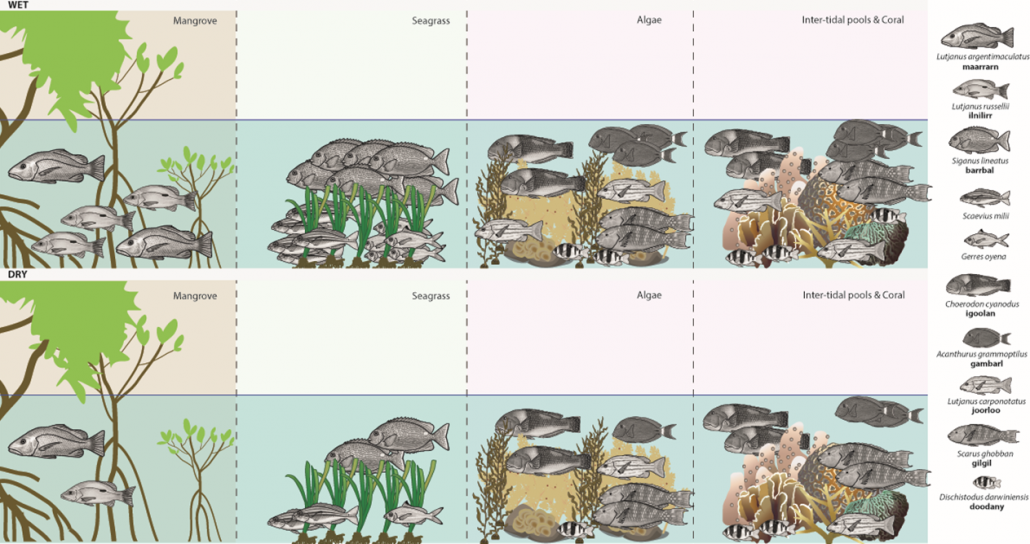
Above: WAMSI Recruitment and Herbivory infographic of findings for juvenille fish RUV: Different types of fish live in different habitats during different seasons. (Cure et. al.)

POSTERS

BOOKLET

Jigeedany (dolphin) survey DBCA_Dambimangari_Booklet

STORY MAPS

VIDEOS

EDUCATION RESOURCES

Data Science STEM resources in collaboration with Education Services Australia

GRAPHICS

RELATED LINKS

The Blueprint for Marine Science – how far have we come in five years?

In 2015 an ambitious plan to drive the priorities for marine research in Western Australia led by industry and government heavyweights delivered the Blueprint for Marine Science to 2050 strategy. Five years into the journey a member of the then Premier’s roundtable for Marine Science and Austral Fisheries CEO David Carter says in some areas the pace is picking up with lightening speed.

The comprehensive industry, government and community consultation process culminating in the Blueprint for Marine Science 2050 Report identified the areas where knowledge gaps will undermine effective management, streamlined regulation and development of marine industries.

One of Australia’s largest integrated commercial fishing companies, Austral Fisheries, operates in an environment which is seeing the effects of climate change first hand and is committed to sustainability based on science.

“The 2016 marine heatwave event wiped out 7000 hectares of seagrass in the Gulf of Carpentaria, it also raised concerns about toothfish catch rates and stock assessment and saw us look at a  multidisciplinary approach to determine the Patagonian toothfish response to environmental variables by bringing together a range of expertise, data and historical evidence to find out what was going on,” David Carter said. “It’s been an interesting and useful project that speaks to the sort of changes we are facing and focuses our need to respond.”

It’s estimated the world will need to feed nine billion people by 2050. David Carter says there are going to be some choices and trade-offs to make and the solutions lie around getting the science right for that but also communicating with those communities that are going to be impacted.

“Just being able to focus on the way we are heading really puts into perspective the challenges ahead,” David said. “Not just locally but globally, as the demands on our marine environment become greater we come to realise the shear enormity of the challenge. It’s therefore critically important that we harness the best and brightest minds to come up with answers to questions that haven’t even been asked yet, and as part of that it’s critical that we bring communities and all stakeholders along.”

One of the strong recommendations to come out of the Blueprint report was the need to improve access to existing data and in 2020 the Department of Water and Environmental Regulation (DWER) and WAMSI, launched the Index of Marine Surveys for Assessments (IMSA) for the systematic capture and sharing of marine data created as part of an environmental impact assessment (EIA).

Each year IMSA is estimated to capture and consolidate more than $50 million worth of industry data collected to support assessments under the Environmental Protection Act 1986 (the EP Act).

According to David Carter it’s a shift in attitude that needed to happen.

“It’s terrific to learn now there is an onus on the need to share data,” he said. “Oil and gas are starting to provide these baseline environmental assessments. I think it’s got to count as one of the major leaps forward.”

The ocean industries are immensley valuable and if as a society and as an economy we want to continue to grow David Carter believes the Western Australian Marine Science Institution has helped to crystalise the focus on the foundation of a long-term collaboration between all sectors operating in the marine environment.

“I believe we are heading in the right direction,” David Carter said. “Greater connections have been made across science and industry as a result of the work of WAMSI and its partners. Talks have been generated around oil platform decommissioning and you can see the pace of discussion around ocean energy transformation is accelerating at light speed. We are talking to Austal Ships and engineers about future fuels to see if we can run a ship on renewable energy but we have still got a way to go.

“We have all the ingredients in this state to become a global powerhouse, to show what’s possible and we have endless renewable energy potential. We have these engineers in oil and gas ready to be rechallenged in renewable fuels – so they know about oil and gas and they are interested, committed and passionate about what’s possible.

“As we reflect with gratitude on the contribution that fossil fuels have made to our standard of living, we also understand that this chapter is closed and that we have a new chapter to write that is equally exciting and challenging and filled with opportunity.”

The Western Australian Marine Science Institution (WAMSI) became custodians of the Blueprint in 2018 to continue to action the strategic science priorities, align the research sectors’ response and establish a foundation of willingness across multiple sectors to find ways to be more strategic and more collaborative in marine science.

The WAMSI Partnership:

WAMSI Partners

WAMSI Science Leads to Jobs Growth

Perth-based environmental and oceanographic consultancy, O2 Marine attributes Western Australian Marine Science Institution dredging science as a key factor that contributed to its rapid organic growth and business success.

When O2 Marine began in 2014 with just two scientists and some big ideas to fill a gap in the niche areas of marine environmental monitoring and assessment advice, the timing couldn’t have been better.

By 2017 the results from the Western Australian Marine Science Institution’s (WAMSI’s) five-years of research into environmental pressures, response and ecological sensitivity from dredging operations off the Pilbara coast, including ground-breaking experiments in the lab, had begun to hit the desk of the State’s environmental regulators.

The new understanding of environmental effects and windows of opportunity provided a significant improvement in the certainty around environmental management of dredging operations in Western Australia.

At the time, O2 Marine was working with Onslow Marine Support Base Pty. Ltd. on a ~1M cubic metre dredging proposal to allow offshore vessels to access the newly constructed Beadon Creek Maritime Facility.

O2 Marine Managing Director, Chris Lane says the WAMSI research was directly applicable to some of the benthic communities and habitats the project could potentially impact.

“The Environmental Protection Authority encouraged us to incorporate the WAMSI dredging science into the assessment,” Chris Lane said. “In doing so, we were able to use real data from Chevron’s Wheatstone project to predict the impacts and experimental laboratory data to define an appropriate monitoring and management approach. As a result, the Onslow Marine Support Base received the fastest regulatory approval for a dredging project of that size ever achieved in W.A.. We effectively halved the assessment approval timeframe from 12-18 months down to six months.”

Chris Lane attributes the opportunity to leverage the WAMSI research as a significant catalyst which effectively put O2 Marine on the map.

“Being able to leverage that science made clients sit up and take notice of what could be achieved by a West Australian small business,” Chris said. “Off the back of this client recognition and with a lot of hard work, O2 Marine has created nearly 40 new jobs, expanded our service offering to include metocean and hydrographic services and achieved annual revenue growth of over 90% per annum. Having that science readily available made it a lot easier to assist our clients in fast-tracking environmental approvals. It was the trigger for us to grow and get that market share.”

In February of 2018 the EPA confirmed that the Onslow Marine Support Base had been recommended for approval. In a statement issued by the EPA, Deputy Chariman Robert Harvey said:

“The proponent incorporated contemporary and locally relevant dredging science from the Western Australian Marine Science Institution into its predictions and proposed management of the project’s impacts. This means we had a high level of confidence during the assessment.

“The use of the latest dredging science, as well as the conditions identified by the EPA, including the implementation of a Dredging and Spoil Disposal Management Plan, means the proposal can be managed in an environmentally acceptable way,” the statement read.

The WAMSI Dredging Science Node was made possible through $9.5 million invested by Woodside, Chevron and BHP as environmental offsets. A further $9.5 million was co-invested by the WAMSI Joint Venture partners. The Node was also supported through critical data provided by Chevron, Woodside and Rio Tinto Iron Ore.