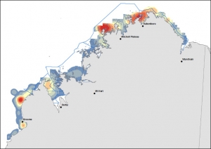
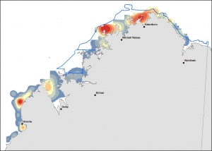
Saltwater crocodile populations continue to grow in Prince Regent River

Population growth rates of estuarine (saltwater) crocodiles in the West Kimberley region of Western Australia do not appear to be slowing, with steady increases in total numbers observed, along with a more gradual increase in the number of large crocodiles (> 3m ~ 10 ft).

There has been a 259% increase in non-hatchling crocodile numbers since the last survey of the Prince Regent system in 1986, some 30 years ago.

The presence of large creek systems adjacent to the main river are allowing sub-adult crocodiles (1.5 – 2m ~ 5-7 ft) to remain near the river of their birth, rather than having to undergo migrations or increased rates of mortality from competition by larger crocodiles. This results in sub-adults making up ~ 20% of the resident crocodile population, compared to 8% in the Adelaide River in the NT, where the crocodile population is considered stable.

Lead researcher for the Western Australian Marine Science Institution’s (WAMSI) saltwater crocodile project, Dr Andy Halford (Parks and Wildlife), when comparing the crocodile recovery in the Kimberley with that in the Northern Territory (NT) said: “Continuous research and surveys in the Northern Territory since the 1980s showed the NT population was considered to have recovered from hunting (outlawed in 1971) by 2000 and we would expect a similar pattern in WA.”

However, comparison of results with established crocodile population patterns in the NT’s Adelaide River indicates that the West Kimberley crocodile populations are still recovering from the large-scale hunting that prevailed pre 1970.

“We counted a total of 5 crocodiles >3m in length in comparison with 63 counted in the Adelaide River and we estimated a biomass density of 91.4 kg/km compared with 274.02 kg/km in the Adelaide River,” Dr Halford said.

“These findings confirm the likelihood of increasing interactions between crocodiles and humans.


“The interesting difference is that, while a lot of crocodiles between  (1.5-2m ~ 5-7 ft) long are usually eaten or killed by larger crocodiles or forced to move into new territory, the percentage of young adults entering the West Kimberley system is up to three times that seen in the NT,” he explained.


“What this study has told us is that while crocodile populations are healthy and recovering well, because of the unique environment and the considerably smaller amount of appropriate nesting habitats in the West Kimberley, exactly how the future recovery will pan out is unclear.

“What we do know is that there will be increased interactions between crocodiles and humans, and in order to provide advice on managing this, we need to learn more about the amount of available nesting habitat throughout the region, as well as updating our surveys of other river systems,” Dr Halford said.

Dr Halford’s full presentation is available on the WAMSI saltwater crocodile project webpage


The $30 million Kimberley Marine Research Program is funded through major investment supported by $12 million from the Western Australian government’s Kimberley Science and Conservation Strategy co-invested by the WAMSI partners and supported by the Traditional Owners of the Kimberley.


Category:

Kimberley Marine Research Program

Kimberley dolphin project covers new ground

By Dr Alex Brown

WAMSI-supported researchers have been in the Cambridge Gulf and Prince Regent River working with local rangers to find out more about the distribution, abundance and population structure of the Australian snubfin (Orcaella heinsohni) and humpback (Sousa sahulensis) dolphins.

The Australian snubfin and humpback dolphins are found in coastal and estuarine waters across northern Australia and the aim of the Kimberley Marine Research Program’s dolphin project is to contribute data towards assessment of their conservation status.

The first trip saw researchers Dr. Alex Brown (Murdoch University Cetacean Research Unit) and Dr. Simon Allen collaborate with the Balanggarra Rangers to perform a two-week survey in the Cambridge Gulf and adjacent coastal waters.

The aims were to:

  1. collect data on the relative abundance and genetic connectivity of coastal dolphins; and
  2. provide rangers with camera equipment and training in dolphin survey techniques – part of a project funded by the Commonwealth Government and WWF-Australia to support the capacity of Indigenous rangers across northern Australia to conduct dolphin research and monitoring.

Following a day of training presentations and exercises, the research team established a base camp at Lacrosse Island, 85 km north of Wyndham, providing good access to the remote waters at the top of the Cambridge Gulf. The support of Department of Parks and Wildlife’s utility vessel Joowinyin was essential to move food, fuel and equipment to the island.

A view of Turtle Bay and our camp from ‘Telstra Hill’. (Photo Alex Brown)


Using the ranger boat, the team covered a 476 km area, focusing on the northwest of the Gulf between the Lynne and Helby Rivers but also covering the open coast west to the Berkeley River, north along King Shoal and Medusa Bank, and east around Cape Domett.

Balanggarra Rangers, Wesley (left) and Wayne (centre left), assist with photo-identification alongside researcher Simon Allen (right) and skipper Andy Yardley (centre right). (Photo: Alex Brown)


Both species were encountered throughout the area surveyed, including the river mouth habitats, which they are known to often frequent, but also along less sheltered sections of open coast and where shallow waters extended further offshore.

Snubfin dolphins were sighted 22 times, while 18 schools of humpback dolphins were observed – providing ample opportunities for the Balanggarra Rangers to develop their data collection skills.

The survey team attempted to quantify the number of dolphins in the area by taking photographs of unique markings on their dorsal fins. However, many of the animals were too shy to be approached close enough for high-quality photos (< 50 m), and only one quarter of all dolphins approached could be properly recorded.

The boat-shy behaviour, which is not uncommon in these species, also limited the team’s success in using a darting system to obtaining tissue samples for genetic analyses – a single humpback dolphin sample being the total from the trip.

Snubfin dolphins (Photo: Pete O’Connor, Dambimangari Rangers)


On the second trip, Dr. Brown joined Parks and Wildlife and Dambimangari Rangers on PV Worndoom for an eight-day survey in Lalang-garram / Camden Sound Marine Park, focussing on the popular Prince Regent River.

Regular sightings of snubfin and humpback dolphins suggest this to be an important habit for these species – both of which are key indicators of marine park health under the management plan.

Photo-identification techniques were more successful in this area, and biopsy darting provided an additional two snubfin dolphin genetic samples.

With this initial survey complete, an ongoing monitoring program will be developed to allow park managers to monitor the status of tropical dolphin species in key parts of the park.

Overall, these data add to our understanding of the distribution and relative abundance of tropical inshore dolphins off northwest Australia, and provide comparisons to encounter rates at other studied sites in the western Kimberley.

The genetic samples will be analysed alongside others from the region, providing a starting point for further data collection and investigations of population connectivity in the Kimberley.


The $30 million Kimberley Marine Research Program is funded through major investment supported by $12 million from the Western Australian government’s Kimberley Science and Conservation Strategy co-invested by the WAMSI partners and supported by the Traditional Owners of the Kimberley.

Category:

Kimberley Marine Research Program

Survey indicates strong support for Kimberley coast protection

By Murdoch University News

Research indicates strong public support for protecting and conserving much of the Kimberley coastline according to a report for WAMSI’s Kimberley Marine Science Program.

Murdoch University scientist Dr Jennifer Strickland-Munro and her research team conducted an online survey of more than 370 people to find the majority placed a high value on conservation and protection across the coast, including sites not covered by Marine Protected Areas (MPAs). Increased Aboriginal management was also highly valued.


“The survey results should be considered in the future planning strategies and management of the Kimberley coast and marine environment,” Dr Strickland-Munro said.

Two marine parks have been established along the coast; at Eighty Mile Beach and Lalang-garram/Camden Sound with proposals for three more at Roebuck Bay, Horizontal Falls and North Kimberley.

The Kimberley MPAs are managed for multiple uses including biodiversity conservation, Aboriginal culture and heritage, nature-based tourism, commercial fishing and aquaculture, science/education, recreation and recreational fishing.

The survey asked respondents to place markers on a map to show the coastal and marine areas they valued along with their management preferences for the region. The results showed there were no unvalued places along the entire Kimberley coast.

Figure 2: Responses across the different value categories. Subsistence included food, collection


“We also found that pro-conservation preferences dominated, but significant differences in responses suggest the potential for conflict over future management,” Dr Strickland-Munro said.

Fifteen per cent of the preferences mapped in the survey were pro-development, with resource related preferences supporting commercial fishing, new port and oil and gas developments.

Many value and preference hotspots were located outside the existing and proposed MPAs, including the northern tip of the Dampier Peninsula, the Buccaneer Archipelago and King Sound near Derby.

Figure 3: Hotspot map for values relating to the ‘physical landscape’.  Numbers are the frequency for ‘physical landscape’ values. The location of hot spots varied according to value type. However, Roebuck Bay, the western and northern coastal fringes and marine environments of Dampier Peninsula, the Buccaneer Archipelago, Horizontal Falls and Talbot Bay, and Montgomery Reef appeared as hot spots for a number of values. Sites northward of this also appeared as hotspots, although of less intensity than other area.


“Our findings reinforce the importance of taking a broader, comprehensive and regional view to marine conservation,” Dr Strickland-Munro said.

“In Australia, as elsewhere in the world, marine and coastal management have struggled to include diverse values, knowledge systems and cultural contexts,” she explained. “These social elements of planning are much more challenging to include compared with the biological and physical attributes of MPAs.

“MPAs can be politically-driven in their boundaries and zoning or these processes may not provide the time or resources for significant stakeholder involvement during planning phases to ensure lasting public support.

“The participatory mapping we used in our survey can be a powerful tool to help address this issue, connecting resource users, planners and managers.

“Our research contributes to marine spatial planning, which helps to identify potential conflicts among users and is particularly useful for large areas like the Kimberley that contain both State and Commonwealth jurisdictions,” Dr Strickland-Munro said.

Links:

Social values and aspirations for coastal waters of the Western Kimberley project page

Social values and aspirations for coastal waters of the Western Kimberley Report

Research Articles:

Strickland-Munro J, Kobryn H, Brown G, Moore S (2016) Valuing The Wild, Remote And Beautiful: Using Public Participation Gis To Inform Tourism Planning In The Kimberley, Western Australia International Journal of Sustainable Development and Planning DOI: 10.2495/SDP-V11-N3-355-364

Strickland-Munro J, Kobryn H, Brown G, Moore S (July 2016) Marine spatial planning for the future: Using Public Participation GIS (PPGIS) to inform the human dimension for large marine parks Marine Policy DOI: 10.1016/j.marpol.2016.07.011

Pearce J, Strickland-Munro J, Moore S (June 2016) What fosters awe-inspiring experiences in nature-based tourism destinations?, Journal of Sustainable Tourism, DOI: 10.1080/09669582.2016.1213270

Brown G, Strickland-Munro J, Kobryn H, Moore S (Dec 2015) Stakeholder analysis for marine conservation planning using public participation GIS Applied Geography DOI:10.1016/j.apgeog.2015.12.004

The $30 million Kimberley Marine Research Program is funded through major investment supported by $12 million from the Western Australian government’s Kimberley Science and Conservation Strategy co-invested by the WAMSI partners and supported by the Traditional Owners of the Kimberley.


Category:

Kimberley Marine Research Program

Tide turning for Kimberley crocodiles

By Kandy Curran, Roebuck Bay Working Group

An audience of more than 100 people at the latest Science on the Broome Coast series were surprised to hear the tide is turning in different directions for the two species of crocodiles in the Kimberley region.

CSIRO freshwater crocodile biologist Dr Ruchira Somaweera, and Parks and Wildlife estuarine crocodile scientist Dr Andrew Halford, presented their research findings at the University of Notre Dame campus on September 20, 2016.

Whilst Dr Somaweera predicts a likely severe decline in freshwater crocodile numbers in some parts of the Kimberley with the invasion of cane toads, Dr Andrew Halford’s research shows estuarine crocodile numbers increasing steadily since full protection in 1997.

Freshie hatching (Photo: Ruchira Somaweera)

Dr Somaweera said that although cane toads are the biggest threat to freshies, other threats include invasive weeds such as exotic passionfruit vine that can choke river bank nesting habitats, bycatch in fishing, and predation by their saltwater relatives.

Two studies in the Northern Territory along the Daly and Victoria River systems showed significant  population declines (77% and 60% respectively), highlighting the concern for the Kimberley freshie.

Dr Somaweera said there is hope however for Crocodylus johnstoni. Recent studies show freshwater crocodile hatchlings are intelligent and can develop a taste aversion for toxic toads if they experience a non-fatal experience from eating a juvenile that has made them ill.

Dr Ruchira Somaweera presenting at Science on the Broome Coast

“I think we will see a phase of severe decline, and then those that have adapted will form a stronger population,” Dr Somaweera said.

Dr Halford is finding a steady increase in numbers of larger saltwater crocodiles as the population matures over time. Surveys conducted along the Roe and Prince Regent Rivers show a significant increase in the population of ‘salties’.

“Numbers (of saltwater crocodiles) are up in the range of a 100 to 300 per cent increase since 1997 – when their numbers were estimated to be as low as 2,500,” Dr Halford said. “It’s been 30 years, so it’s a very clear example of what happens when you take human predators out of the equation.”

Dr Halford said that increased population density is forcing younger males to move south, hence the increase in sightings around Broome in recent years. It’s not clear if these animals will establish breeding populations around Broome and further south as this will depend on the availability of suitable nesting habitat.

Freshie taking off (Photo: Ruchira Somaweera)


The Science on the Broome Coast series is hosted by the Roebuck Bay Working Group and Yawuru Land and Sea Unit in Broome, and sponsored by Inspiring Australia, Rangelands NRM through the Federal Government Landcare program, State NRM through Royalties for Regions, Western Australian Marine Science Institution, Department of Parks and Wildlife and University of Notre Dame Broome.


Category:

Kimberley Marine Research Program

Crowdsourcing for the Kimberley Marine Environments

By: Moataz Kordi (Curtin University)

The crowdsourcing data approach for information gathering has been used worldwide for a variety of purposes, from creating and sharing geographic information volunteered by individuals through common and freely available platforms such as Wikimapia and OpenStreetMap, to assisting in human crises situations through programs such as Ushahidi.

The crowdsourcing approach has also been employed in many scientific endeavours, including Geo-Wiki, with volunteers helping to improve the quality of global land cover maps.

Crowdsourcing data approach has facilitate the way researchers and managers receive information from the field. (Moataz Kordi)

Recent studies have discussed the benefits of scientific research in open collaborative projects using the ‘crowd science’ or ‘citizen science’ approach.

As an example, community participation played a significant role in re-zoning the Great Barrier Reef Marine Park Authority (GBRMPA).

Also, volunteer involvement in the monitoring program Reef Watch, coordinated by the Conservation Council of South Australia for the sustainable management of marine ecosystems, has helped increase knowledge about the status of temperate reefs in South Australia.

Volunteer divers and snorkelers also recorded about 180 marine species in Victoria, Australia, through the monitoring initiative Reef Watch Victoria, developed by the Victoria National Parks Association and Museum Victoria to protect Victoria’s marine environment.

Another remarkable monitoring program called Eye on the Reef, managed by GBRMPA, in partnership with the Queensland Parks and Wildlife Service, enables visitors to the Great Barrier Reef to report reef observations though smartphones or tablets application. The data provide Marine Park managers and researchers with up-to-date information on current reef status.

Traditional owners and rangers have valuable information on the marine environment and they are willing to share their knowledge for the sake of conservation of this vital ecosystem (Tubagus Solihuddin)

During field work in the Kimberley Bioregion for the Western Australian Marine Science Institution’s Geomorphology project, it was noticed that many people connected with the marine environment including the rangers, fishermen, pearl farmers, traditional owners, nature photographers and tourists, had valuable scientific information, such as site images, underwater videos and photos, and aerial photography of marine fauna and flora, including reefs.

The idea that a wide group within the Kimberley community were willing to share their valuable knowledge let to the development of ReefKIM, a similar crowdsourcing geodatabase in which researchers were able to compile existing spatial and non-spatial data, as well as collecting new data to complete information gaps.

This information has had a significant role in the verification of satellite images when reef habitats and substrates were being mapped. And all of the people we met were willing to share their knowledge for the sake of conservation of this vital ecosystem.

This demonstrated to us that crowdsourcing provides valuable opportunities for individuals to engage in activities with environmental purpose. So let us get together and share our valuable knowledge to protect our magnificent marine environment of the Kimberley.

Related papers:

  1. Bufarale G, Collins LB, O’Leary MJ, Stevens A, Kordi M, Solihuddin T (2016). Quaternary onset and evolution of Kimberley coral reefs (Northwest Australia) revealed by high-resolution seismic imaging. Journal of Continental Shelf Research, 123, 80–88 doi:10.1016/j.csr.2016.04.002
  2. Kordi, M.N., and O’Leary, M. (2016). Geomorphic classification of reefs in the north western Australia Shelf. Regional Studies in Marine Science, DOI 10.1016/j.rsma.2016.05.012.
  3. Kordi, M.N., and O’Leary, M. (2016) A Spatial Approach to Improve Coastal Bioregion Management of the North Western Australia. Ocean & Coastal Management, 127, 26-42 doi:10.1016/j.ocecoaman.2016.04.004
  4. Solihuddin T, O’Leary M, Blakeway D, Parnum I, Kordi M, Collins L (March 2016) Holocene reef evolution in a macrotidal setting: Buccaneer Archipelago, Kimberley Bioregion, Northwest Australia Coral Reefs DOI 10.1007/s00338-016-1424-1
  5. Kordi M.N., Collins, L.B., O’Leary M, Stevens A (November 2015) ReefKIM: An integrated geodatabase for sustainable management of the Kimberley Reefs, North West Australia Ocean & Coastal Management doi:10.1016/j.ocecoaman.2015.11.004
  6. Kordi M.N., Collins, L.B. and Stevens A. (2015). A Large Scale Geomorphological and Surficial Cover Map of Nearshore Reefs in the Kimberley Coast, WA. In Proceedings from Coast to Coast Conference 2014, Mandurah, Western Australia. ISBN-10: 0994357206 pp 15–20
  7. Collins, L.B., O’Leary, M.J., Stevens, A. M., Bufarale, G., Kordi, M., Solihuddin, T, 2015. Geomorphic Patterns, internal architecture and Reef Growth in a macrotidal, high turbidity setting of coral reefs from the Kimberley Bioregion. Australian Journal of Maritime & Ocean Affairs, Volume 7, Issue 1, pp 12-22. (open access from Nov 2017)
  8. Kordi, M.N., Collins, L.B., and Stevens, A. (2015). Geomorphic Patterns, Habitats and Substrates of Macrotidal Reefs from the Kimberley, North West Australia. In Proceedings from 2015 WAMSI Research Conference, Perth, Western Australia pp 72


The $30 million Kimberley Marine Research Program is funded through major investment supported by $12 million from the Western Australian government’s Kimberley Science and Conservation Strategy co-invested by the WAMSI partners and supported by the Traditional Owners of the Kimberley.

Category:

Kimberley Marine Research Program

Indigenous knowledge key to mapping dugong populations


The dugong aerial survey, undertaken in partnership with the Balanggarra, Wunambal Gaambera,Dambimangari and Bardi Jawi ranger groups, was completed in October 2015.

Research leader for WAMSI’s dugong management project in the Kimberley, CSIRO’s Dr Peter Bayliss, released initial results ahead of a satellite and acoustic tagging field trip later this year.

“Our initial estimate is that there are about 12,000 dugongs (plus or minus a 12% error) in the North Kimberley, a density of 0.36 per km2 over about 33,000 km2 of coastal waters surveyed (Table 1),” Dr Bayliss reported. “The density estimate is similar to those found for other regions of northern Australia that also have large areas of seagrass habitat in clear shallow (< 20 m) coastal waters. Whilst we use the most updated scientific corrections for the proportion of dugongs under the water and missed by observers during surveys, it is important to understand that our estimates of abundance should still be treated as “minimum” estimates. The only way to reliably estimate absolute or true numbers would be to use recently developed close-kin genetic methods, developed by CSIRO for Southern Bluefin Tuna and applied to many other difficult to observe marine species”.

Table 1. Estimates of population size (N̂ + SE) and density (D̂ + SE km-2) of dugongs in the North Kimberley (Sept. – Oct. 2015) using updated methods to correct counts for the number of animals missed during the survey. SE and %SE are the Standard Error and percentage SE, respectively.

Block

SE

% SE

SE

3

1,758

452

25.7

0.22

0.06

4

2,119

444

21.0

0.28

0.06

5

2,926

792

27.1

0.55

0.15

6

3,682

929

25.2

0.69

0.17

7

636

170

26.7

0.31

0.08

8

541

112

20.7

0.26

0.05

9

177

43

24.0

0.07

0.02

Total

11,839

(+ 1,391)

11.8

0.36

(+ 0.04)

“The main aim of the project is to integrate Indigenous Ecological Knowledge of dugongs with scientific survey data to help develop culturally appropriate and more effective monitoring tools for dugong management,” Dr Bayliss said.

A method was trialled to integrate Indigenous Ecological Knowledge with scientific survey data to help identify important dugong areas. Three sources of knowledge were used: (i) Indigenous Ecological Knowledge (location of important dugong areas mapped in Healthy Country Plans); (ii) the seagrass map developed from satellite images; and (iii) the dry season abundance estimates from the aerial survey in September-October 2015.

“The method gives strong weighting to Indigenous Knowledge as it represents knowledge accumulated over millennium time periods compared to the “snapshots” of scientific observational data taken over very short time frames,” Dr Bayliss said.

Abundance “hotspots”

The distribution and abundance maps of dugongs and other marine wildlife species (e.g. large turtles, dolphins) are illustrated twice in the team’s 2016 annual report, with one map showing the Native Title sea country boundaries and the other the Department of Parks and Wildlife WA marine reserve boundaries (i.e. the existing Camden Sound-Lalang-garram marine park & the proposed Horizontal Falls & North Kimberley marine parks), and comprise a valuable planning resource to on-ground managers.

Figure 1 (a & b) identifies dugong abundance “hotspots” using aerial survey data extrapolated and smoothed in a GIS over a fine spatial scale. Red colours represent high density, blue colours low density areas with an intermediate colour scale between these two extremes (orange, yellow & grey colours).

  1. DUGONG relative abundance “hotspots” mapped by GIS smoothing (extrapolation) methods of observed transect observations across a high resolution grid (~1.8 km x 1.8 km) for (a) Native Title sea country

  1. DUGONG relative abundance “hotspots” mapped by GIS smoothing (extrapolation) methods of observed transect observations across a high resolution grid (~1.8 km x 1.8 km) for (b) proposed and existing marine reserve areas. 

    DUGONG relative abundance “hotspots” mapped by GIS smoothing (extrapolation) methods of observed transect observations across a high resolution grid (~1.8 km x 1.8 km) for (b) proposed and existing marine reserve areas.

Proportion of calves

Calves were identified by their small size and close proximity to another, larger animal. About 6% (21/350) of all dugongs seen were reported as calves and these sightings were spread evenly throughout the Kimberley coastal waters. The proportion is about mid-way between those reported elsewhere across northern Australia (3-14% for the Northern Territory & 14% for the Torres Strait) and likely reflects regional and seasonal differences.

Indigenous Ecological Knowledge

The WAMSI Dugong research project combines Indigenous and scientific knowledge through partnership and full participation of Balanggarra, Wunambal Gaambera, Dambimangari and Bardi Jawi ranger groups.

“The partnership approach has been successful in developing the first baseline in the Kimberley for the distribution and abundance of dugongs using standardised aerial survey methods, and most of that success was due to an intensive pre-survey training course run jointly with the ranger groups at Gambimerri ranger station on Wunambal Gaambera Country. The movement study commencing in August using satellite and acoustic tagging technologies will adopt the same partnership approach to combine our different skills and to share knowledge” Dr Bayliss said.

“We have also trialled a focussed two-day interview process with Dambimangari elders and senior Traditional Owners who have cultural knowledge of dugongs,” Dr Bayliss said. “The interviews were successful in providing important insights into the cultural value of dugongs and additional information on important dugong areas. We hope to extend these focussed interviews to other Kimberley groups willing to share their dugong stories.”

The Indigenous partnership work developed on the WAMSI Dugong project will be  developed further through WAMSI’s Indigenous Knowledge project.

The $30 million Kimberley Marine Research Program is funded through major investment supported by $12 million from the Western Australian government’s Kimberley Science and Conservation Strategy co-invested by the WAMSI partners and supported by the Traditional Owners of the Kimberley.

Category:

Kimberley Marine Research Program

Kimberley coastal system: links from the land to the deep sea

By Dr Matthew Hipsey (UWA), Prof Greg Ivey (UWA) and Dr Jim Greenwood (CSIRO)

The Kimberley is known to have a unique geography and support an amazing amount of biodiversity, but until know we have not really understood what drives the base of the food web – what we call productivity. Is it nutrients entering coastal regions from the ocean or is loading of material from land via the complex estuary systems supplying the essential nutrients required to drive production?

Given the high-tidal range and very unique and complex coastal morphometry, we also want to understand how nutrients and the key players in the microbial food web are impacted by seasonal changes in ocean currents and mixing.  Overall, we have therefore set out to understand the hydrodynamic and biogeochemical controls on productivity, and then to use this information to consider how future changes will impact these systems.

Simulation results showing the effect of inflows and sediment resuspension on turbidity (“Suspended Solids”) within the coastal embayments of Collier Bay and Walcott Inlett


Both the regional-scale and local-scale dynamics within a given reach of coast will ultimately determine how it functions. We have identified at both scales the importance of the large tidal range in shaping nutrient availability.

Somewhat paradoxically, at the regional scale tidal and open ocean dynamics encourages upwelling of nutrients from the deep ocean and into the coastal regions, but at the embayment scale the large tides and induced strong currents (up to 3 m/s) are responsible for flushing terrestrial derived nutrients away from the coast. Nutrient supply is therefore highly dynamic in time and space, leading to complex patterns in primary productivity across the Kimberley shelf and within the coastal archipelagos.

In the dry season conditions,  water masses can be retained in embayments for  time-scales varying with exact location but lying in the range between just a few days up five months. In the wet season conditions, there is enhanced flushing and these timescales are approximately halved.

Particle tracking animation demonstrating the complex currents and flow paths experienced within Collier Bay

Whilst the delivery of nutrients is an important driver of primary productivity, within Kimberley estuaries and embayments, this is complicated by highly turbid water, limiting light available for photosynthesis, particularly near the coast.

Model simulation results showing the variation in physical and biogeochemical parameters across Collier Bay (from within Walcott Inlet to the outer shelf area of the Kimberley) during the March 2014 wet season. The parameters are Salinity (psu), Suspended Solids (mg/L), Nitrate and Dissolved Organic Nitrogen (mmol/m3), and two types of phytoplankton (mol/m3).


Despite the low light levels, the intense tidal flows sustain high rates of vertical mixing  and the phytoplankton community has uniquely adapted to these niche conditions, being able to rapidly photosynthesise in the thin layer near the surface for short periods,  differentiating them from their open-ocean counter-parts that are most productive deeper within the water column.

Overall, the rates of primary production across the region were as high as other tropical waters in Australia, and interestingly the rates of secondary production – that is grazing of phytoplankton by zooplankton – were reported to be significantly higher than the Great Barrier Reef, providing a rich food supply to local food-webs.

Model simulation results showing the variation across Collier Bay (from Walcott Inlet to the outer shelf area of the Kimberley). The key parameters (TCHLA: total chlorophyll-a; GPP: gross primary productivity; fI: light limitation; fNIT: nutrient limitation) for assessing productivity demonstrate the transition between nutrient and light limited environments.

These findings have allowed the development of several high-resolution model tools able to compute the changes in oceanographic conditions, nutrient cycling and primary production that can be used to help understand and manage the system into the future.

Project links

2.2.1 Oceanographic dynamics

2.2.2 Biogeochemical processes

2.2.6 Land-ocean linkages

Presentations

WAMSI Lunch and Learn Seminar: The flow of energy through the Kimberley coastal system – from the land to the deep sea.


The $30 million Kimberley Marine Research Program is funded through major investment supported by $12 million from the Western Australian government’s Kimberley Science and Conservation Strategy co-invested by the WAMSI partners and supported by the Traditional Owners of the Kimberley.

Category:

Kimberley Marine Research Program

Kimberley seabed survey expected to reveal new species

Scientists on a mission to better understand the ecological biodiversity that thrives on the ocean floor in Australia’s remote northwest returned from the fourth of five field trips, this time to uncover what lives in the area of the proposed North Kimberley Marine Park.

Dr Andrew Heyward, from the Australian Institute of Marine Science, leads the Western Australian Marine Science Institution (WAMSI) Benthic Biodiversity project and provided this update.

By Dr Andrew Heyward (AIMS)

The WAMSI Kimberley project continued to expand the seabed survey area, extending to waters of the far north in a recent voyage. Multibeam acoustics was used to map depth and geomorphology, while the biota growing on the seabed was studied using towed cameras and, in representative areas, a small sled was deployed to collect samples for the biota.

As with other regions surveyed by ship, a high number of species were observed and it is expected many will be new to science.

The seabed sled comes aboard with a sample including  sponges, algal covered rocks and sea whips (Image: Andrew Heyward)

However, the sea life encountered, while somewhat different from place to place, was very similar in terms of ecosystem function.

The ship based research spent most of the time in navigable waters deeper than 10 metres and most sampling focused on the depth band between 15-50 metres. These areas are often turbid and organisms that need light were not major components of the seabed communities. Rather, animals that filter the water or eat detritus on and in the seabed were predominant. In all places visited to date, sponges have been the most common and largest organisms encountered. Echinoderms, soft corals and bryozoans also featured routinely.

The survey results are still being analysed but point to much of the deeper Kimberley waters often having low levels of large sessile marine life (those organisms that spend their lives attached to the substrate), but in places where rocks and ridges provide a place to settle and hold on, quite diverse and abundant benthic communities exist.

The role of light in supporting abundant benthic primary production, such as algae, seagrasses and stony corals, seems likely to be most important in the shallower margins, less than around 15 metres below low tide.

Shoreline areas and fringing reefs with abundant corals and plants are throughout the Kimberley, but are yet to be surveyed in any detail from the large ship-based field expeditions.

Future work is being planned, in collaboration with local Indigenous sea rangers, to gather additional nearshore data on some of these key shallow water habitats.

The results will be added to the data collected from the recent field trip aboard RV Solander to the islands of the Bonaparte Archipelago to investigate the coral reefs, sponges and other marine life inhabiting this remote area of the Kimberley.

Scientists on the back deck of RV Solander  sorting a sled catch into biological groups prior to processing as voucher specimens destined for the WA Museum. (Image: Andrew Heyward)

The Solander voyages include researchers from AIMS, the Western Australian Museum, CSIRO and Curtin University.

The $30 million Kimberley Marine Research Program is funded through major investment supported by $12 million from the Western Australian government’s Kimberley Science and Conservation Strategy co-invested by the WAMSI partners and supported by the Traditional Owners of the Kimberley.

Category:

Kimberley Marine Research Program

Whales from space

By: Cassidy Newland (AIMS)

It’s as strange as it sounds… researchers are looking for whales in the Kimberley from a vantage point of 770 kilometres above sea level using the Worldview 2 Satellite.

The Satellite captures a spatial resolution of 0.46 metre pixels in the Panchromatic band and a spatial resolution of 1.6 metre pixels in the 8 band Multispectral image (Figure 1).


The Panchromatic band captures light across the visible spectrum in a single band and is often displayed as a grey scale image. It has a higher spatial resolution of up to 0.46m, but a lower spectral resolution than the multispectral. The multispectral has 8 bands extending from the far blue through the visible spectrum to the near infra-red providing higher spectral resolution but the spatial resolution is only up to 1.6m.

A number of surveys by different organisations had previously been carried out in the Kimberley by plane, boat and some from land and for the first stage I looked for an image in the World view 2 archive to match one of these.

Although there is a large archive of imagery since the satellite commenced operation in 2009, matching an exact date was difficult and we were lucky to find several images matching surveys conducted in August 2010. I acquired one image which I expected would have the most whales and began the task of looking for them.

At 12-16 metres long you might expect a Humpback whale to be relatively easy to distinguish, but in the multispectral image with 1.6m pixels, a whale seen fully surfaced will only be up to 10 pixels long. Figure 2 shows a simulation based on an actual aerial photo of what a whale might look like in a satellite image.


In actuality only a single fully surfaced whale was distinguishable, but with a lot of interpretation and a little imagination a range of whale related features were identified including partially surfaced whales, submerged whales, the foot print of recently surfaced whales, bubble rings from below and even what appears to be a bubble net.

These features are examined in each band to see where they can be best distinguished and determine what band or combination of bands will be used in the analysis to identify further features. There is also testing of the similarity of features within a type and testing of separability of each type. The result is a refined set of features which can then be used to train and verify success of the remote sensing techniques used.

The techniques used included thresholding where cut-off values are defined manually, supervised classifications using the features as training sites and unsupervised classifications where clusters are identified statistically. Of these, thresholding and unsupervised classification provided the best results.

Challenges were noise from shallow water, swell and turbidity, but it was possible to identify surfaced whales, whale footprints, some submerged whales and boats.


Related Links:

WAMSI Project 1.2.1 Humpback Whale Distribution project

ABC Kimberley’s Erin Parke talks to WAMSI/AIMS researcher Michele Thums about satellite tagging humpback whales:

The $30 million Kimberley Marine Research Program is funded through major investment supported by $12 million from the Western Australian government’s Kimberley Science and Conservation Strategy co-invested by the WAMSI partners and supported by the Traditional Owners of the Kimberley.

Category:

Kimberley Marine Research Program

Broome boat ramp study indicates boating popularity

Researchers have analysed a year’s worth of video imagery from the popular Entrance Point boat ramp, adjacent to the Broome Fishing Club, to explore the factors affecting the launching of recreational boats, as part of a broader WAMSI study looking at Human Use in the Kimberley.

In total, 6057 recreational boat launches were recorded by the Western Australian Department of Fisheries camera at Entrance Point during the 12 month study. The figure shows that, despite the town of Broome only having a relatively small resident population of about 13,000 people, boating is a popular activity.

To put it into context, the total at Entrance Point is equivalent to about 22 per cent of the total number of launches per year at Hillarys boat ramp which is one of the busiest in the Perth Metropolitan area.

On a seasonal basis, 60 per cent of all boat launches at Entrance Point occurred during the dry, winter season (May to October) and on a monthly basis, July and August had the highest numbers of boat launches (totals of 825 and 882, respectively).

The average number of boat launches per day generally showed an increase on weekends although from July to September there were increased numbers of launches on weekdays as well.

Throughout the year, the peak in boat launching took place in the morning between 6 am and 10 am.

Mean hourly boat launch rate per month at Entrance Point boat ramp, Broome, from November 2012 to October 2013.

“The results support the original hypothesis that there would be an increase in boat launches during the dry, winter season when there are known to be more visitors (especially ‘grey nomads’) to Broome,” project leader Murdoch University’s Professor Lynnath Beckley said. “However, consistent launching of boats during the wet, summer season (40 per cent of all launches) clearly indicates the importance the residents of Broome place on recreational boating.”

The boat launching data were also explored relative to environmental factors like air and sea temperature, wind speed and direction, rainfall, barometric pressure and tides as well as time of day, day type (weekday, weekend or public holiday) and school holidays.

Time series analyses of the hourly launch data showed that day type, time of day, school holidays and tidal height were significant predictors that together described the most variation in the launches on a daily cycle.  For the weekly cycle, only day type and wind speed were significant predictors.

“The Entrance Point boat ramp is only one of several sites from where recreational boats are launched in Broome and this may have some bearing on the patterns found,” Professor Beckley said. “For example, during the winter mornings when there can be strong easterly winds, many boats are launched instead from the southern end of Cable Beach which is more protected from these winds.”

Entrance Point boat ramp at Broome in peak season (Lynnath Beckley)

The $30 million Kimberley Marine Research Program is funded through major investment supported by $12 million from the Western Australian government’s Kimberley Science and Conservation Strategy co-invested by the WAMSI partners and supported by the Traditional Owners of the Kimberley.

Category:

Kimberley Marine Research Program