Temperatures soaring in surface and deeper water causing fish kills and coral bleaching

Elevated sea temperatures that have caused fish kills and coral bleaching along Western Australia’s coast, have been detected as far deep as 300 metres in some areas.

The Western Australian Marine Science Institution (WAMSI) is managing the ‘Advancing predictions of WA marine heatwaves and impacts on marine ecosystems’ project which aims to better predict and manage marine heatwaves.  It is primarily funded by the Department of Jobs, Tourism, Science and Innovation in WA.

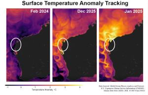
Dr Jessica Benthuysen, an oceanographer from the Australian Institute of Marine Science (AIMS), who is one of the scientists working on the project, said the marine heatwave extended across much of the northwest.

“The temperatures reached unprecedented levels through December and January.” Dr Benthuysen .

“In mid to late January we saw warm waters exceeding three degrees above normal along the shelf from the southern Pilbara to Ningaloo and Shark Bay.”

“Monitoring shows the warm temperatures are not confined to just surface waters and have reached to at least 300 metres in the past few months, which has helped the extreme event to remain for such an extended period,” she said.

While southerly winds had provided some recent relief at Ningaloo, Dr Benthuysen said extremely warm waters had brought an early heat shock to underwater ecosystems well above the temperatures they would typically experience in March or April when waters tend to be warmest.

“With our partners we will continue to monitor temperatures along the coast with the help of the AIMS weather station at Ningaloo, eight coastal buoys deployed through this project, and Integrated Marine Observing System (IMOS) moorings and gliders.”

The equipment is being used to gather information for the heatwave project and feedback vital data to WAMSI’s partners about the current event.

WAMSI CEO Dr Luke Twomey said the marine heatwave project was an important one given the damage caused by marine heatwaves.

“For this project, WAMSI has brought together experts from across our partnership and beyond and also across various specialties” – Dr Twomey.

AIMS research scientist Dr James Gilmour said a collaborative approach was helpful to assess the full impact.

“We are working with our networks across management, research, Traditional Owner groups and other stakeholders to gather information on the bleaching but it will be some time before outcomes for WA reefs are understood,” Dr Gilmour said.

“Corals can recover from bleaching or they can also die – this process can take time and there are many variables influencing the outcome.”

“We will work with partners to interpret monitoring data from the many remote reefs in the vast expanse of the northwest,” he said.

Project scientists come from organisations including Bureau of Meteorology, Curtin University, Department of Biodiversity, Conservation and Attractions, Department of Primary Industries and Regional Development, Edith Cowan University, Murdoch University and The University of Western Australia.

Data from the smart moorings, including wave and temperature information, is publicly available at: www.wawaves.org

Photos by Dr Chris Fulton from the Australian Institute of Marine Science (AIMS) in collaboration with the Department of Biodiversity Conservation and Attractions (DBCA).

A powerful force is stopping the Indian Ocean from cooling itself – spelling more danger for Ningaloo

Widespread coral bleaching at Ningaloo Reef off Western Australia’s coast has deeply alarmed scientists and conservationists.

Photos captured by divers, published by The Guardian last week, show severe bleaching at several sites along the reef, which runs for 260 kilometres off the state’s northwest.

A severe marine heatwave in the Indian Ocean off WA has caused the coral bleaching. In some places, surface temperatures up to 4°C warmer than usual have been recorded.

Hotter temperatures aren’t only happening at the ocean’s surface – data indicates they also extend several hundred metres deep. Warm, deeper water can shut down the ocean’s natural cooling process, putting corals at even greater risk of bleaching.

Counting the cost

Scientists will conduct field surveys in coming months.

The full extent of damage to Ningaloo won’t be known until scientists conduct field surveys in coming months.

So far, bleaching has been documented at several sites, including Turquoise Bay, Coral Bay, Tantabiddi, and Bundegi (Exmouth Gulf).

Other sites such as Scott Reef, Ashmore Reef, the Rowley Shoals and Rottnest Island are also at risk.

Damage wrought by the heatwave extends beyond coral. More than 30,000 fish have died since the September onset.

The below images show the heatwave’s progression. Temperatures from February last year are included for comparison.

The white circle shows the location of Ningaloo. Cooler temperatures are in blue and purple. Warmer temperatures are in yellow and orange.

The images show the heatwave reached Ningaloo in December last year and moved south in January. Temperatures fell slightly in February due to strong southerly winds. From March, temperatures are forecast to increase again.

Image showing the progression of an ocean heatwave down the WA coast. Ningaloo is marked by the white circle. CMEMS

A complex warming picture

According to recent data and modelled forecasts, hotter ocean temperatures off northern WA run several hundred metres deep.

This has been caused by developing La Nina conditions. La Nina and its opposite, El Nino, influence ocean temperatures and weather patterns across the Pacific.

During La Nina, trade winds strengthen and push warm water westward. This intensifies two important ocean currents.

The first is the Indonesian Throughflow – which carries warm Pacific waters through the Indonesian seas and into the eastern Indian Ocean. The second is the Leeuwin Current, which picks up this warm water and takes it further south towards Perth.

This has led to a build-up of hotter water along the WA coastline.

La Nina is also affecting WA’s reefs in other ways.

Some coral reefs are naturally cooled by local tides which pull deep, colder water towards the surface. This process, which has been likened to an ocean’s “air conditioner”, can temporarily relieve heat stress for reefs.

The process relies on “stratification” – that is, layers of seawater that differ in temperature, salinity and density (or weight). Warmer, less dense water collects at the surface and colder, denser water falls to deeper levels.

La Nina conditions can suppress, or even shut down, this cooling effect in two ways.

First, it reduces the difference in density between ocean layers. This causes water to draw upwards from shallower depths. Second, it increases water temperatures at depth.

All this means the water pumped to the surface isn’t much cooler than temperatures at the surface.

For many reefs along the coast of WA, the suppression of this tidal cooling is probably contributing to worsening conditions, and more coral bleaching.

Most bleaching forecasts rely on sea surface temperatures. This means scientists may be underestimating the vulnerability of deeper reefs.

What’s in store for Ningaloo and surrounds?

Looking ahead, the situation at Ningaloo and surrounding reefs remains critical.

Bleached reefs are able to recover if temperatures cool quickly. This means theoretically, Ningaloo and other affected reefs may survive the summer.

But unfortunately, temperatures are rising again and the marine heatwave is expected to continue until April, as the below image shows.

Climate change is making marine heatwaves more intense and frequent. It means reefs often don’t have time to recover between destructive bleaching events.

All this is compounded by the general trend towards warmer oceans as the planet heats up.

Drastic action on climate change is needed now. If this alarming pattern continues, the world’s reefs risk being lost entirely.

The project,

This article by Kelly Boden-Hawes and Professor Nicole Jones from The University of Western Australia, was originally published in The Conversation on 24 February 2025.

WAMSI is leading the project ‘Advancing predictions of Western Australian marine heatwaves and impacts on marine ecosystems’ which brings together scientists from around Australia who are developing improved knowledge and practical tools to forecast extreme ocean temperatures and their impacts on Western Australia’s (WA’s) marine ecosystems.

A marine heatwave in northwest Australia is killing huge numbers of fish. It’s heading south

This article by Sina Pinter, Matt Rayson and Professor Nicole Jones from The University of Western Australia, was originally published in The Conversation on 29 January 2025.

Tens of thousands of fish have died off northwestern Australia, as a large and long-lasting marine heatwave intensifies.

The fish kill at Gnoorea Beach near Karratha is concerning our team of scientists, as the hot mass of water heads south towards Ningaloo Reef and the seagrass gardens in Shark Bay. That’s because we’ve seen this before. An enormous marine heatwave in 2010-11 devastated fisheries and ecosystems further down the WA coast.

This marine heatwave began in September, with temperatures up to 3°C warmer than usual off Broome. There’s no end in sight.

The heatwave comes as oceans worldwide experience recordbreaking heat, driven by climate change. More than 90% of all heat trapped by greenhouse gases goes into the oceans.

The fish kill is a visible way to glimpse a disaster often out of sight and out of mind. But these marine heatwaves do much more, from wiping out seagrass meadows and kelp beds to trashing fisheries.

How bad is this marine heatwave?

Marine heatwaves are periods of at least five consecutive days when ocean temperatures are significantly higher than the long-term average for the region and season. Since September 2024, temperatures off Australia’s northwest coast have been high enough to be considered a heatwave.

2024-25 marine heatwave in Western Australia

The heatwave is at its most severe in waters between Karratha and Broome, but the heat is heading south.

In late December, the area of hotter water expanded southward along the Pilbara coast and became more intense. Temperatures hit 4–5°C above normal at the surface. Our research group has gathered data from satellite measurements, which tells us it’s hotter than usual. Data from autonomous ocean gliders also show unusual levels of heat as far down as 200 metres.

In January, this heatwave has become bad enough to be classified in some areas as a severe marine heatwave.

There’s no relief in sight yet. The Bureau of Meteorology forecasts marine heatwave conditions to continue through February.

Will it be worse than the 2010 heatwave?

The current marine heatwave is, so far, the second-worst in Western Australia’s recorded history.

Over the 2010–11 summer, a severe marine heatwave devastated seas off the state. Temperatures hit up to 5°C above average, peaking in February and March.

The worst-hit areas were seas off the central West Australian coastline, leaving those to the north largely unaffected. But the heatwave stretched 2,000 kilometres, from the Pilbara all the way down to Denmark in the southwest.

The reason the 2010 heatwave spread so far south was due to the Leeuwin Current, which was stronger than usual due to weak southerly winds linked to a low pressure system off the coast.

The heat led to local extinction of kelp species along a 100km stretch of coastline. Scallop and blue swimmer crab fisheries had to close. Seagrass meadows in Shark Bay collapsed. Tropical species were sighted in new areas. And coral bleached at Ningaloo.

By contrast, this current marine heatwave has concentrated on the northern coastline, but may spread south in coming weeks.

Unfortunately, there are strong similarities between the 2010–11 heatwave and this one. Both occurred during a La Niña year.

A similar low pressure system in December 2024 weakened southerly winds during this heatwave, though not as pronounced as in 2010-11. We can expect to see the Leeuwin Current intensify and carry more warm water than usual south, but perhaps not as far as in 2010–11.

Weather systems at present are developing slightly differently to 2010–11, but they could still lead to weaker southerly winds and produce a stronger current channelling heat.

What does this mean for ocean life?

Marine heatwaves at this size and intensity can profoundly damage marine ecosystems and fisheries. The Karratha fish kill is the most visible sign of ecosystem distress.

We have already seen signs of bleaching in the coral reefs of the Kimberley region, while corals are experiencing heat stress at world-famous Ningaloo Reef. The heat is now affecting the Gascoyne region between Carnarvon and Exmouth, and is likely to head further south.

Damage from the heatwave could threaten valuable industries such as the rock lobster fishery and marine tourism on the Coral Coast.

More heatwaves will come

As the climate changes, modelling indicates marine heatwaves will hit more often and to intensify.

Worldwide, marine heatwaves have devastated ecosystems. One of the worst, the Pacific “blob” heatwave of 2014-2016, killed an estimated 100 million Pacific cod and four million birds from a single seabird species, as well as contributing to the starvation of about 7,000 humpback whales. The intense heat killed off cold-loving species and paved the way for tropical species to enter and even thrive.

Right now, 28% of the world’s oceans are in heatwave conditions, based on surface temperatures.

While there is a clear link between the 2010-11 marine heatwave and climate change, we cannot conclusively say this current heatwave off Western Australia is linked to climate change.

That’s because we don’t have enough data about what’s happening under the surface. Temperatures in the ocean vary greatly by depth, and a hot surface doesn’t always mean heat has reached deeper water.

So while we know a marine heatwave is in progress, we don’t know how bad it is or how far down the heat has reached in different regions. We need better ways to measure temperatures at depth, to be able to gauge how bad a heatwave is. Installing more temperature sensors along the WA coastline would allow us to better monitor and respond to temperature extremes.

The earlier we know about a heatwave, the more we can do to prepare. The 2010-2011 heatwave made many people aware of what damage heat can do to an ocean, as fishing boats sat idle and tourists steered clear of dying coral.

More, and worse, is likely to come. Better conservation and management of our oceans can help. But tackling the root cause of intensifying heat – unchecked greenhouse gas emissions – is still far and away the most important challenge.