The Coastal Oceanography Group at The University of Western Australia has been developing a numerical system to provide atmospheric and ocean forecasts for five days in advance.
The forecasts include five regions along the coast of Western Australia: west coast (North-west Cape to Cape Leeuwin), central coast, Shark Bay, south-west and Perth. Perth is on a higher resolution nested grid. The dates are also in a drop down menu.
The forecasts include Atmospheric (winds, air pressure, rainfall) and ocean (currents, sea surface temperature and salinity).
Project leader, Professor Charitha Pattiaratchi said the forecasts provide a very high resolution view of the ocean and atmospheric conditions – on a regional basis.
“They add-value to the Bureau of Meteorology forecasts,” he said. “This will be a valuable source of information to people who use the local marine environment including recreational and professional fisherman, scientists planning field work. The forecasts are also archived so we can go back in time and extract historic conditions.”
https://wamsi.org.au/wp-content/uploads/2019/07/Web-_0002_tim-marshall-82948-unsplash.jpg12001800adminhttps://wamsi.org.au/wp-content/uploads/2019/04/WAMSI-Logo-300x92.pngadmin2016-06-28 09:10:072019-12-03 12:07:13New tool to forecast atmospheric and ocean conditions on the west coast
With sea turtles revered by cultures across the world, it was a privilege to have Yawuru Ranger Preston Manado open the Science on the Broome Coast presentation, Sea Turtles: Iconic ambassadors linking marine habitats, cultures and regions in north-western Australia on June 8, 2016.
Preston began by explaining the significance of the six Yawuru saltwater seasons – starting with the Laja and Man-gala seasons when the gurlibil (Flatback turtle – Natator depressus) lay their eggs on Broome’s beaches. The eggs of the gurlibil will hatch approximately 55 days after nesting.
“Gurlibil is out to sea during the colder months of Barrgana, which we are having now. During Wirlburu, the warming up season when the westerly winds start to blow, Gurlibil start mating and shouldn’t be disturbed.” Preston Manado said.
The next presenter, Dr Scott Whiting, who is the Principal Research Scientist with Parks and Wildlife in Perth, focused on the biology of sea turtles, the threats that they are facing – particularly from climate change, and research underway on the Kimberley coast.
Dr Whiting had the audience ‘taking their hats off’ to sea turtles, with their biology and evolutionary history so amazing.
“Sea turtles, which can weigh from 30kg to 600kg, frequently dive to depths of 100m, with some species diving to as deep as 1000m. The length of time they take to reach puberty (30 to 50 years) and their long breeding histories (over 30 years), is extraordinary too, as it means that conservation initiatives have to be considered in terms of decades and centuries.” Dr Whiting said.
A wandering microphone allowed the large audience of 76 to ask a stream of great questions. For example, the question of how turtles mate, revealed that female sea turtles are promiscuous and can be mated by several males, resulting in several fathers of the egg clutch. The next question – where are the most species of sea turtles found, delighted the Broome audience, with Roebuck Bay identified as an embayment visited by at least five species of sea turtles, with the Green turtle (Chelonia mydas) most dominant, and Flatback turtles the species nesting on Broome’s beaches. We also learned that whilst turtles have small brains, they have evolved with special ‘homing’ abilities, which will see them return when they reach puberty, to precisely the same beach where they hatched from 30 to 50 years ago.
The big question however is, will sea turtles, which evolved 200 million years ago, adapt quickly enough to cope with a rapidly changing climate and a world that is overpopulating?
The next Science on the Broome Coast presentations are Corals, canaries and cockroaches: A natural history of coral reefs on June 29, followed by Lustre: The allure of mother of pearl crosses time and cultures on July 6 – both at the University of Notre Dame Multipurpose Hall in Broome.
This innovative Science on the Broome Coast series is sponsored by Inspiring Australia, The University of Notre Dame Broome, Yawuru Land and Sea Unit, Western Australia Marine Science Institution, Rangelands NRM through the Federal Government Landcare Program and the Department of Parks and Wildlife.
https://wamsi.org.au/wp-content/uploads/2019/07/Web-_0002_tim-marshall-82948-unsplash.jpg12001800adminhttps://wamsi.org.au/wp-content/uploads/2019/04/WAMSI-Logo-300x92.pngadmin2016-06-28 08:46:022019-12-03 12:07:13Hats off to sea turtles
If you go for a snorkel near the shore you will find meadows of gently swaying seagrasses and rocky reefs with brightly colored algae that are often called seaweeds. Among these swaying leaves and algal fronds live myriads of tiny creatures. Marine plants act as nurseries, providing shelter and food for almost all our marine species at some time in their lives.
Finding the tiny sea ‘insects’, which are known as macro invertebrates is always exciting. These little creatures feed on the soft algae, and seagrass leaves and on the harder chalky coralline algae that grow on seagrass. They also eat plankton and occasionally they eat each other. In turn, they are delicious morsels for tiny fish and crustaceans that are then food for larger fish and shore birds.
The next time you come to the beach bring a small white bucket (to let in the light) and a magnifying glass. Make sure your bucket is clean with no residue of paint or cleaning chemicals. Fill it with fresh seawater. Find a wire-weed seagrass stem with a fringe of red brown algae and place it gently in your bucket without shaking and add a couple of branches of some leafy seaweed. If you wait for a moment you will notice lots of tiny creatures zipping around.
Geraldton Grammar students discovering macro invertebrates (A.Rossen)
You are likely to find amphipods, tiny prawn like animals and bristle worms, flatworms, and transparent or green shrimp. You may be lucky enough to find an anemone larvae or a sediment (sand) worm with waving tentacles and external gills that look like soft antlers. Some tiny invertebrates also make tunnels in seagrass leaves and live within those very narrow spaces. Also attached to seagrass leaves are minute spiral tube worms with delicate transparent feeding arms that comb through the water to catch floating bits of food. Try to get some good photos with your phone camera before you carefully return these treasures to the ocean.
Amphipod on seagrass (A. Rossen)
All these plants and creatures are perfectly adapted to their environment and are very sensitive to poisonous pollutants that enter the ocean. For example, road water drains are designed to divert stormwater into rivers and to the seashore. Unfortunately they also bring rubbish, fertilizers from gardens and other pollutants from the roads. Remember these tiny creatures when you fertilize your garden and always dispose of liquid waste and rubbish correctly.
Angela Rossen is Artist in Residence with The Oceans Institute at The University of Western Australia
Related links:
If you want to find out more about the tiny creatures that live in the marine plants call Angela Rossen to talk about a Coastal Biodiversity Art Workshop with your community or school group visit www.angelarossen.com
https://wamsi.org.au/wp-content/uploads/2019/07/Web-_0002_tim-marshall-82948-unsplash.jpg12001800adminhttps://wamsi.org.au/wp-content/uploads/2019/04/WAMSI-Logo-300x92.pngadmin2016-06-27 16:02:002019-12-03 12:07:13Discovering the Tiny Creatures that Live in Marine Plants
The crowdsourcing data approach for information gathering has been used worldwide for a variety of purposes, from creating and sharing geographic information volunteered by individuals through common and freely available platforms such as Wikimapia and OpenStreetMap, to assisting in human crises situations through programs such as Ushahidi.
The crowdsourcing approach has also been employed in many scientific endeavours, including Geo-Wiki, with volunteers helping to improve the quality of global land cover maps.
Crowdsourcing data approach has facilitate the way researchers and managers receive information from the field. (Moataz Kordi)
Recent studies have discussed the benefits of scientific research in open collaborative projects using the ‘crowd science’ or ‘citizen science’ approach.
As an example, community participation played a significant role in re-zoning the Great Barrier Reef Marine Park Authority (GBRMPA).
Also, volunteer involvement in the monitoring program Reef Watch, coordinated by the Conservation Council of South Australia for the sustainable management of marine ecosystems, has helped increase knowledge about the status of temperate reefs in South Australia.
Volunteer divers and snorkelers also recorded about 180 marine species in Victoria, Australia, through the monitoring initiative Reef Watch Victoria, developed by the Victoria National Parks Association and Museum Victoria to protect Victoria’s marine environment.
Another remarkable monitoring program called Eye on the Reef, managed by GBRMPA, in partnership with the Queensland Parks and Wildlife Service, enables visitors to the Great Barrier Reef to report reef observations though smartphones or tablets application. The data provide Marine Park managers and researchers with up-to-date information on current reef status.
Traditional owners and rangers have valuable information on the marine environment and they are willing to share their knowledge for the sake of conservation of this vital ecosystem (Tubagus Solihuddin)
During field work in the Kimberley Bioregion for the Western Australian Marine Science Institution’s Geomorphology project, it was noticed that many people connected with the marine environment including the rangers, fishermen, pearl farmers, traditional owners, nature photographers and tourists, had valuable scientific information, such as site images, underwater videos and photos, and aerial photography of marine fauna and flora, including reefs.
The idea that a wide group within the Kimberley community were willing to share their valuable knowledge let to the development of ReefKIM, a similar crowdsourcing geodatabase in which researchers were able to compile existing spatial and non-spatial data, as well as collecting new data to complete information gaps.
This information has had a significant role in the verification of satellite images when reef habitats and substrates were being mapped. And all of the people we met were willing to share their knowledge for the sake of conservation of this vital ecosystem.
This demonstrated to us that crowdsourcing provides valuable opportunities for individuals to engage in activities with environmental purpose. So let us get together and share our valuable knowledge to protect our magnificent marine environment of the Kimberley.
https://wamsi.org.au/wp-content/uploads/2019/07/Web-_0002_tim-marshall-82948-unsplash.jpg12001800adminhttps://wamsi.org.au/wp-content/uploads/2019/04/WAMSI-Logo-300x92.pngadmin2016-06-27 15:36:232021-01-22 16:51:42Crowdsourcing for the Kimberley Marine Environments
The dugong aerial survey, undertaken in partnership with the Balanggarra, Wunambal Gaambera,Dambimangari and Bardi Jawi ranger groups, was completed in October 2015.
Research leader for WAMSI’s dugong management project in the Kimberley, CSIRO’s Dr Peter Bayliss, released initial results ahead of a satellite and acoustic tagging field trip later this year.
“Our initial estimate is that there are about 12,000 dugongs (plus or minus a 12% error) in the North Kimberley, a density of 0.36 per km2 over about 33,000 km2 of coastal waters surveyed (Table 1),” Dr Bayliss reported. “The density estimate is similar to those found for other regions of northern Australia that also have large areas of seagrass habitat in clear shallow (< 20 m) coastal waters. Whilst we use the most updated scientific corrections for the proportion of dugongs under the water and missed by observers during surveys, it is important to understand that our estimates of abundance should still be treated as “minimum” estimates. The only way to reliably estimate absolute or true numbers would be to use recently developed close-kin genetic methods, developed by CSIRO for Southern Bluefin Tuna and applied to many other difficult to observe marine species”.
Table 1. Estimates of population size (N̂ + SE) and density (D̂ + SE km-2) of dugongs in the North Kimberley (Sept. – Oct. 2015) using updated methods to correct counts for the number of animals missed during the survey. SE and %SE are the Standard Error and percentage SE, respectively.
Block
N̂
SE
% SE
D̂
SE
3
1,758
452
25.7
0.22
0.06
4
2,119
444
21.0
0.28
0.06
5
2,926
792
27.1
0.55
0.15
6
3,682
929
25.2
0.69
0.17
7
636
170
26.7
0.31
0.08
8
541
112
20.7
0.26
0.05
9
177
43
24.0
0.07
0.02
Total
11,839
(+ 1,391)
11.8
0.36
(+ 0.04)
“The main aim of the project is to integrate Indigenous Ecological Knowledge of dugongs with scientific survey data to help develop culturally appropriate and more effective monitoring tools for dugong management,” Dr Bayliss said.
A method was trialled to integrate Indigenous Ecological Knowledge with scientific survey data to help identify important dugong areas. Three sources of knowledge were used: (i) Indigenous Ecological Knowledge (location of important dugong areas mapped in Healthy Country Plans); (ii) the seagrass map developed from satellite images; and (iii) the dry season abundance estimates from the aerial survey in September-October 2015.
“The method gives strong weighting to Indigenous Knowledge as it represents knowledge accumulated over millennium time periods compared to the “snapshots” of scientific observational data taken over very short time frames,” Dr Bayliss said.
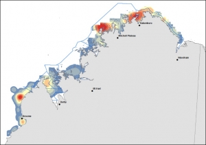
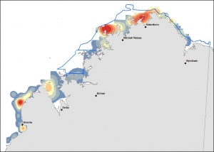
Abundance “hotspots”
The distribution and abundance maps of dugongs and other marine wildlife species (e.g. large turtles, dolphins) are illustrated twice in the team’s 2016 annual report, with one map showing the Native Title sea country boundaries and the other the Department of Parks and Wildlife WA marine reserve boundaries (i.e. the existing Camden Sound-Lalang-garram marine park & the proposed Horizontal Falls & North Kimberley marine parks), and comprise a valuable planning resource to on-ground managers.
Figure 1 (a & b) identifies dugong abundance “hotspots” using aerial survey data extrapolated and smoothed in a GIS over a fine spatial scale. Red colours represent high density, blue colours low density areas with an intermediate colour scale between these two extremes (orange, yellow & grey colours).
DUGONG relative abundance “hotspots” mapped by GIS smoothing (extrapolation) methods of observed transect observations across a high resolution grid (~1.8 km x 1.8 km) for (a) Native Title sea country
DUGONG relative abundance “hotspots” mapped by GIS smoothing (extrapolation) methods of observed transect observations across a high resolution grid (~1.8 km x 1.8 km) for (b) proposed and existing marine reserve areas.
Proportion of calves
Calves were identified by their small size and close proximity to another, larger animal. About 6% (21/350) of all dugongs seen were reported as calves and these sightings were spread evenly throughout the Kimberley coastal waters. The proportion is about mid-way between those reported elsewhere across northern Australia (3-14% for the Northern Territory & 14% for the Torres Strait) and likely reflects regional and seasonal differences.
Indigenous Ecological Knowledge
The WAMSI Dugong research project combines Indigenous and scientific knowledge through partnership and full participation of Balanggarra, Wunambal Gaambera, Dambimangari and Bardi Jawi ranger groups.
“The partnership approach has been successful in developing the first baseline in the Kimberley for the distribution and abundance of dugongs using standardised aerial survey methods, and most of that success was due to an intensive pre-survey training course run jointly with the ranger groups at Gambimerri ranger station on Wunambal Gaambera Country. The movement study commencing in August using satellite and acoustic tagging technologies will adopt the same partnership approach to combine our different skills and to share knowledge” Dr Bayliss said.
“We have also trialled a focussed two-day interview process with Dambimangari elders and senior Traditional Owners who have cultural knowledge of dugongs,” Dr Bayliss said. “The interviews were successful in providing important insights into the cultural value of dugongs and additional information on important dugong areas. We hope to extend these focussed interviews to other Kimberley groups willing to share their dugong stories.”
The Indigenous partnership work developed on the WAMSI Dugong project will be developed further through WAMSI’s Indigenous Knowledge project.
Sediment researchers may have cracked a key to early recognition of coral stress by observing mucous build-up in response to dredge related sediment.
The research undertaken as part of the Western Australian Marine Science Institution’s Dredging Science Node found that colonies of the massive stony coral Porites, located off Barrow Island, produced mucous sheets that encompassed the entire colony in response to settling and suspended sediment.
Lead researcher PhD candidate Pia Bessell-Browne from The UWA Oceans Institute and AIMS says it’s the first time scientists have been able to view sediment related stress on coral from a dive in situ.
“This study has examined the production of mucous sheets through time on tagged colonies that were monitored during a large scale dredging project,” Pia explained. We looked at the coral health monitoring photos and noticed the phenomenon of increased mucus production near dredging activity. We also ran experiments with the same species to confirm results at the AIMS Sea Simulator aquarium facility.”
Experimental work undertaken in the National Sea Simulator observed similar patterns of mucus production in Porites fragments after exposure to elevated sediment deposition
A number of hypotheses have been proposed to explain why and how this sheet production occurs, yet at this stage there isn’t enough quantitative data on mucus production and associated potential triggers to confirm whether it is a result of suspended or deposited sediment.
The results suggest that the production of mucus is closely linked with the presence of sediment stressors, where the quantity and characteristics of sediments can affect the physical, chemical, and biological stability of marine ecosystems. A strong relationship between mucus production and distance from dredging was also observed.
“It’s a stress a response,” Pia said. “We still don’t know what the long-term impact is but it is apparent that these corals can produce mucous sheets up to seven times in an 18 month period without suffering substantial mortality.”
The findings suggest that mucous sheet production by massive Porites colonies is an effective indicator of sediment related stress to be considered when monitoring the impacts of suspended sediment on coral populations.
The WAMSI Dredging Science Node is made possible through $9.5 million invested by Woodside, Chevron and BHP as environmental offsets. A further $9.5 million has been co-invested by the WAMSI Joint Venture partners, adding significantly more value to this initial industry investment. The node is also supported through critical data provided by Chevron, Woodside and Rio Tinto Iron Ore.
https://wamsi.org.au/wp-content/uploads/2019/07/Web-_0002_tim-marshall-82948-unsplash.jpg12001800adminhttps://wamsi.org.au/wp-content/uploads/2019/04/WAMSI-Logo-300x92.pngadmin2016-06-27 14:55:132021-01-25 12:58:43Coral colonies respond to sediment with sheets of mucus
The Kimberley is known to have a unique geography and support an amazing amount of biodiversity, but until know we have not really understood what drives the base of the food web – what we call productivity. Is it nutrients entering coastal regions from the ocean or is loading of material from land via the complex estuary systems supplying the essential nutrients required to drive production?
Given the high-tidal range and very unique and complex coastal morphometry, we also want to understand how nutrients and the key players in the microbial food web are impacted by seasonal changes in ocean currents and mixing. Overall, we have therefore set out to understand the hydrodynamic and biogeochemical controls on productivity, and then to use this information to consider how future changes will impact these systems.
Simulation results showing the effect of inflows and sediment resuspension on turbidity (“Suspended Solids”) within the coastal embayments of Collier Bay and Walcott Inlett
Both the regional-scale and local-scale dynamics within a given reach of coast will ultimately determine how it functions. We have identified at both scales the importance of the large tidal range in shaping nutrient availability.
Somewhat paradoxically, at the regional scale tidal and open ocean dynamics encourages upwelling of nutrients from the deep ocean and into the coastal regions, but at the embayment scale the large tides and induced strong currents (up to 3 m/s) are responsible for flushing terrestrial derived nutrients away from the coast. Nutrient supply is therefore highly dynamic in time and space, leading to complex patterns in primary productivity across the Kimberley shelf and within the coastal archipelagos.
In the dry season conditions, water masses can be retained in embayments for time-scales varying with exact location but lying in the range between just a few days up five months. In the wet season conditions, there is enhanced flushing and these timescales are approximately halved.
Particle tracking animation demonstrating the complex currents and flow paths experienced within Collier Bay
Whilst the delivery of nutrients is an important driver of primary productivity, within Kimberley estuaries and embayments, this is complicated by highly turbid water, limiting light available for photosynthesis, particularly near the coast.
Model simulation results showing the variation in physical and biogeochemical parameters across Collier Bay (from within Walcott Inlet to the outer shelf area of the Kimberley) during the March 2014 wet season. The parameters are Salinity (psu), Suspended Solids (mg/L), Nitrate and Dissolved Organic Nitrogen (mmol/m3), and two types of phytoplankton (mol/m3).
Despite the low light levels, the intense tidal flows sustain high rates of vertical mixing and the phytoplankton community has uniquely adapted to these niche conditions, being able to rapidly photosynthesise in the thin layer near the surface for short periods, differentiating them from their open-ocean counter-parts that are most productive deeper within the water column.
Overall, the rates of primary production across the region were as high as other tropical waters in Australia, and interestingly the rates of secondary production – that is grazing of phytoplankton by zooplankton – were reported to be significantly higher than the Great Barrier Reef, providing a rich food supply to local food-webs.
Model simulation results showing the variation across Collier Bay (from Walcott Inlet to the outer shelf area of the Kimberley). The key parameters (TCHLA: total chlorophyll-a; GPP: gross primary productivity; fI: light limitation; fNIT: nutrient limitation) for assessing productivity demonstrate the transition between nutrient and light limited environments.
These findings have allowed the development of several high-resolution model tools able to compute the changes in oceanographic conditions, nutrient cycling and primary production that can be used to help understand and manage the system into the future.
https://wamsi.org.au/wp-content/uploads/2019/07/Web-_0002_tim-marshall-82948-unsplash.jpg12001800adminhttps://wamsi.org.au/wp-content/uploads/2019/04/WAMSI-Logo-300x92.pngadmin2016-06-27 14:09:112021-02-16 16:10:02Kimberley coastal system: links from the land to the deep sea
https://wamsi.org.au/wp-content/uploads/2019/07/Web-_0002_tim-marshall-82948-unsplash.jpg12001800adminhttps://wamsi.org.au/wp-content/uploads/2019/04/WAMSI-Logo-300x92.pngadmin2016-06-21 13:31:142019-12-03 12:07:21Industry and government launch WA strategy for marine science collaboration


")
")