Crowdsourcing for the Kimberley Marine Environments

By: Moataz Kordi (Curtin University)

The crowdsourcing data approach for information gathering has been used worldwide for a variety of purposes, from creating and sharing geographic information volunteered by individuals through common and freely available platforms such as Wikimapia and OpenStreetMap, to assisting in human crises situations through programs such as Ushahidi.

The crowdsourcing approach has also been employed in many scientific endeavours, including Geo-Wiki, with volunteers helping to improve the quality of global land cover maps.

Crowdsourcing data approach has facilitate the way researchers and managers receive information from the field. (Moataz Kordi)

Recent studies have discussed the benefits of scientific research in open collaborative projects using the ‘crowd science’ or ‘citizen science’ approach.

As an example, community participation played a significant role in re-zoning the Great Barrier Reef Marine Park Authority (GBRMPA).

Also, volunteer involvement in the monitoring program Reef Watch, coordinated by the Conservation Council of South Australia for the sustainable management of marine ecosystems, has helped increase knowledge about the status of temperate reefs in South Australia.

Volunteer divers and snorkelers also recorded about 180 marine species in Victoria, Australia, through the monitoring initiative Reef Watch Victoria, developed by the Victoria National Parks Association and Museum Victoria to protect Victoria’s marine environment.

Another remarkable monitoring program called Eye on the Reef, managed by GBRMPA, in partnership with the Queensland Parks and Wildlife Service, enables visitors to the Great Barrier Reef to report reef observations though smartphones or tablets application. The data provide Marine Park managers and researchers with up-to-date information on current reef status.

Traditional owners and rangers have valuable information on the marine environment and they are willing to share their knowledge for the sake of conservation of this vital ecosystem (Tubagus Solihuddin)

During field work in the Kimberley Bioregion for the Western Australian Marine Science Institution’s Geomorphology project, it was noticed that many people connected with the marine environment including the rangers, fishermen, pearl farmers, traditional owners, nature photographers and tourists, had valuable scientific information, such as site images, underwater videos and photos, and aerial photography of marine fauna and flora, including reefs.

The idea that a wide group within the Kimberley community were willing to share their valuable knowledge let to the development of ReefKIM, a similar crowdsourcing geodatabase in which researchers were able to compile existing spatial and non-spatial data, as well as collecting new data to complete information gaps.

This information has had a significant role in the verification of satellite images when reef habitats and substrates were being mapped. And all of the people we met were willing to share their knowledge for the sake of conservation of this vital ecosystem.

This demonstrated to us that crowdsourcing provides valuable opportunities for individuals to engage in activities with environmental purpose. So let us get together and share our valuable knowledge to protect our magnificent marine environment of the Kimberley.

Related papers:

  1. Bufarale G, Collins LB, O’Leary MJ, Stevens A, Kordi M, Solihuddin T (2016). Quaternary onset and evolution of Kimberley coral reefs (Northwest Australia) revealed by high-resolution seismic imaging. Journal of Continental Shelf Research, 123, 80–88 doi:10.1016/j.csr.2016.04.002
  2. Kordi, M.N., and O’Leary, M. (2016). Geomorphic classification of reefs in the north western Australia Shelf. Regional Studies in Marine Science, DOI 10.1016/j.rsma.2016.05.012.
  3. Kordi, M.N., and O’Leary, M. (2016) A Spatial Approach to Improve Coastal Bioregion Management of the North Western Australia. Ocean & Coastal Management, 127, 26-42 doi:10.1016/j.ocecoaman.2016.04.004
  4. Solihuddin T, O’Leary M, Blakeway D, Parnum I, Kordi M, Collins L (March 2016) Holocene reef evolution in a macrotidal setting: Buccaneer Archipelago, Kimberley Bioregion, Northwest Australia Coral Reefs DOI 10.1007/s00338-016-1424-1
  5. Kordi M.N., Collins, L.B., O’Leary M, Stevens A (November 2015) ReefKIM: An integrated geodatabase for sustainable management of the Kimberley Reefs, North West Australia Ocean & Coastal Management doi:10.1016/j.ocecoaman.2015.11.004
  6. Kordi M.N., Collins, L.B. and Stevens A. (2015). A Large Scale Geomorphological and Surficial Cover Map of Nearshore Reefs in the Kimberley Coast, WA. In Proceedings from Coast to Coast Conference 2014, Mandurah, Western Australia. ISBN-10: 0994357206 pp 15–20
  7. Collins, L.B., O’Leary, M.J., Stevens, A. M., Bufarale, G., Kordi, M., Solihuddin, T, 2015. Geomorphic Patterns, internal architecture and Reef Growth in a macrotidal, high turbidity setting of coral reefs from the Kimberley Bioregion. Australian Journal of Maritime & Ocean Affairs, Volume 7, Issue 1, pp 12-22. (open access from Nov 2017)
  8. Kordi, M.N., Collins, L.B., and Stevens, A. (2015). Geomorphic Patterns, Habitats and Substrates of Macrotidal Reefs from the Kimberley, North West Australia. In Proceedings from 2015 WAMSI Research Conference, Perth, Western Australia pp 72


The $30 million Kimberley Marine Research Program is funded through major investment supported by $12 million from the Western Australian government’s Kimberley Science and Conservation Strategy co-invested by the WAMSI partners and supported by the Traditional Owners of the Kimberley.

Category:

Kimberley Marine Research Program

Indigenous knowledge key to mapping dugong populations


The dugong aerial survey, undertaken in partnership with the Balanggarra, Wunambal Gaambera,Dambimangari and Bardi Jawi ranger groups, was completed in October 2015.

Research leader for WAMSI’s dugong management project in the Kimberley, CSIRO’s Dr Peter Bayliss, released initial results ahead of a satellite and acoustic tagging field trip later this year.

“Our initial estimate is that there are about 12,000 dugongs (plus or minus a 12% error) in the North Kimberley, a density of 0.36 per km2 over about 33,000 km2 of coastal waters surveyed (Table 1),” Dr Bayliss reported. “The density estimate is similar to those found for other regions of northern Australia that also have large areas of seagrass habitat in clear shallow (< 20 m) coastal waters. Whilst we use the most updated scientific corrections for the proportion of dugongs under the water and missed by observers during surveys, it is important to understand that our estimates of abundance should still be treated as “minimum” estimates. The only way to reliably estimate absolute or true numbers would be to use recently developed close-kin genetic methods, developed by CSIRO for Southern Bluefin Tuna and applied to many other difficult to observe marine species”.

Table 1. Estimates of population size (N̂ + SE) and density (D̂ + SE km-2) of dugongs in the North Kimberley (Sept. – Oct. 2015) using updated methods to correct counts for the number of animals missed during the survey. SE and %SE are the Standard Error and percentage SE, respectively.

Block

SE

% SE

SE

3

1,758

452

25.7

0.22

0.06

4

2,119

444

21.0

0.28

0.06

5

2,926

792

27.1

0.55

0.15

6

3,682

929

25.2

0.69

0.17

7

636

170

26.7

0.31

0.08

8

541

112

20.7

0.26

0.05

9

177

43

24.0

0.07

0.02

Total

11,839

(+ 1,391)

11.8

0.36

(+ 0.04)

“The main aim of the project is to integrate Indigenous Ecological Knowledge of dugongs with scientific survey data to help develop culturally appropriate and more effective monitoring tools for dugong management,” Dr Bayliss said.

A method was trialled to integrate Indigenous Ecological Knowledge with scientific survey data to help identify important dugong areas. Three sources of knowledge were used: (i) Indigenous Ecological Knowledge (location of important dugong areas mapped in Healthy Country Plans); (ii) the seagrass map developed from satellite images; and (iii) the dry season abundance estimates from the aerial survey in September-October 2015.

“The method gives strong weighting to Indigenous Knowledge as it represents knowledge accumulated over millennium time periods compared to the “snapshots” of scientific observational data taken over very short time frames,” Dr Bayliss said.

Abundance “hotspots”

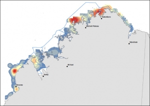
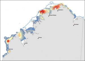
The distribution and abundance maps of dugongs and other marine wildlife species (e.g. large turtles, dolphins) are illustrated twice in the team’s 2016 annual report, with one map showing the Native Title sea country boundaries and the other the Department of Parks and Wildlife WA marine reserve boundaries (i.e. the existing Camden Sound-Lalang-garram marine park & the proposed Horizontal Falls & North Kimberley marine parks), and comprise a valuable planning resource to on-ground managers.

Figure 1 (a & b) identifies dugong abundance “hotspots” using aerial survey data extrapolated and smoothed in a GIS over a fine spatial scale. Red colours represent high density, blue colours low density areas with an intermediate colour scale between these two extremes (orange, yellow & grey colours).

  1. DUGONG relative abundance “hotspots” mapped by GIS smoothing (extrapolation) methods of observed transect observations across a high resolution grid (~1.8 km x 1.8 km) for (a) Native Title sea country

  1. DUGONG relative abundance “hotspots” mapped by GIS smoothing (extrapolation) methods of observed transect observations across a high resolution grid (~1.8 km x 1.8 km) for (b) proposed and existing marine reserve areas. 

    DUGONG relative abundance “hotspots” mapped by GIS smoothing (extrapolation) methods of observed transect observations across a high resolution grid (~1.8 km x 1.8 km) for (b) proposed and existing marine reserve areas.

Proportion of calves

Calves were identified by their small size and close proximity to another, larger animal. About 6% (21/350) of all dugongs seen were reported as calves and these sightings were spread evenly throughout the Kimberley coastal waters. The proportion is about mid-way between those reported elsewhere across northern Australia (3-14% for the Northern Territory & 14% for the Torres Strait) and likely reflects regional and seasonal differences.

Indigenous Ecological Knowledge

The WAMSI Dugong research project combines Indigenous and scientific knowledge through partnership and full participation of Balanggarra, Wunambal Gaambera, Dambimangari and Bardi Jawi ranger groups.

“The partnership approach has been successful in developing the first baseline in the Kimberley for the distribution and abundance of dugongs using standardised aerial survey methods, and most of that success was due to an intensive pre-survey training course run jointly with the ranger groups at Gambimerri ranger station on Wunambal Gaambera Country. The movement study commencing in August using satellite and acoustic tagging technologies will adopt the same partnership approach to combine our different skills and to share knowledge” Dr Bayliss said.

“We have also trialled a focussed two-day interview process with Dambimangari elders and senior Traditional Owners who have cultural knowledge of dugongs,” Dr Bayliss said. “The interviews were successful in providing important insights into the cultural value of dugongs and additional information on important dugong areas. We hope to extend these focussed interviews to other Kimberley groups willing to share their dugong stories.”

The Indigenous partnership work developed on the WAMSI Dugong project will be  developed further through WAMSI’s Indigenous Knowledge project.

The $30 million Kimberley Marine Research Program is funded through major investment supported by $12 million from the Western Australian government’s Kimberley Science and Conservation Strategy co-invested by the WAMSI partners and supported by the Traditional Owners of the Kimberley.
Category:

Kimberley Marine Research Program

Coral colonies respond to sediment with sheets of mucus

Sediment researchers may have cracked a key to early recognition of coral stress by observing mucous build-up in response to dredge related sediment.

The research undertaken as part of the Western Australian Marine Science Institution’s Dredging Science Node found that colonies of the massive stony coral Porites, located off Barrow Island, produced mucous sheets that encompassed the entire colony in response to settling and suspended sediment.

Lead researcher PhD candidate Pia Bessell-Browne from The UWA Oceans Institute and AIMS says it’s the first time scientists have been able to view sediment related stress on coral from a dive in situ.

“This study has examined the production of mucous sheets through time on tagged colonies that were monitored during a large scale dredging project,” Pia explained. We looked at the coral health monitoring photos and noticed the phenomenon of increased mucus production near dredging activity. We also ran experiments with the same species to confirm results at the AIMS Sea Simulator aquarium facility.”

Experimental work undertaken in the National Sea Simulator observed similar patterns of mucus production in Porites fragments after exposure to elevated sediment deposition

A number of hypotheses have been proposed to explain why and how this sheet production occurs, yet at this stage there isn’t enough quantitative data on mucus production and associated potential triggers to confirm whether it is a result of suspended or deposited sediment.

The results suggest that the production of mucus is closely linked with the presence of sediment stressors, where the quantity and characteristics of sediments can affect the physical, chemical, and biological stability of marine ecosystems. A strong relationship between mucus production and distance from dredging was also observed.

“It’s a stress a response,” Pia said. “We still don’t know what the long-term impact is but it is apparent that these corals can produce mucous sheets up to seven times in an 18 month period without suffering substantial mortality.”

The findings suggest that mucous sheet production by massive Porites colonies is an effective indicator of sediment related stress to be considered when monitoring the impacts of suspended sediment on coral populations.

The WAMSI Dredging Science Node is made possible through $9.5 million invested by Woodside, Chevron and BHP as environmental offsets. A further $9.5 million has been co-invested by the WAMSI Joint Venture partners, adding significantly more value to this initial industry investment. The node is also supported through critical data provided by Chevron, Woodside and Rio Tinto Iron Ore.


Category:

Dredging Science

Kimberley coastal system: links from the land to the deep sea

By Dr Matthew Hipsey (UWA), Prof Greg Ivey (UWA) and Dr Jim Greenwood (CSIRO)

The Kimberley is known to have a unique geography and support an amazing amount of biodiversity, but until know we have not really understood what drives the base of the food web – what we call productivity. Is it nutrients entering coastal regions from the ocean or is loading of material from land via the complex estuary systems supplying the essential nutrients required to drive production?

Given the high-tidal range and very unique and complex coastal morphometry, we also want to understand how nutrients and the key players in the microbial food web are impacted by seasonal changes in ocean currents and mixing.  Overall, we have therefore set out to understand the hydrodynamic and biogeochemical controls on productivity, and then to use this information to consider how future changes will impact these systems.

Simulation results showing the effect of inflows and sediment resuspension on turbidity (“Suspended Solids”) within the coastal embayments of Collier Bay and Walcott Inlett


Both the regional-scale and local-scale dynamics within a given reach of coast will ultimately determine how it functions. We have identified at both scales the importance of the large tidal range in shaping nutrient availability.

Somewhat paradoxically, at the regional scale tidal and open ocean dynamics encourages upwelling of nutrients from the deep ocean and into the coastal regions, but at the embayment scale the large tides and induced strong currents (up to 3 m/s) are responsible for flushing terrestrial derived nutrients away from the coast. Nutrient supply is therefore highly dynamic in time and space, leading to complex patterns in primary productivity across the Kimberley shelf and within the coastal archipelagos.

In the dry season conditions,  water masses can be retained in embayments for  time-scales varying with exact location but lying in the range between just a few days up five months. In the wet season conditions, there is enhanced flushing and these timescales are approximately halved.

Particle tracking animation demonstrating the complex currents and flow paths experienced within Collier Bay

Whilst the delivery of nutrients is an important driver of primary productivity, within Kimberley estuaries and embayments, this is complicated by highly turbid water, limiting light available for photosynthesis, particularly near the coast.

Model simulation results showing the variation in physical and biogeochemical parameters across Collier Bay (from within Walcott Inlet to the outer shelf area of the Kimberley) during the March 2014 wet season. The parameters are Salinity (psu), Suspended Solids (mg/L), Nitrate and Dissolved Organic Nitrogen (mmol/m3), and two types of phytoplankton (mol/m3).


Despite the low light levels, the intense tidal flows sustain high rates of vertical mixing  and the phytoplankton community has uniquely adapted to these niche conditions, being able to rapidly photosynthesise in the thin layer near the surface for short periods,  differentiating them from their open-ocean counter-parts that are most productive deeper within the water column.

Overall, the rates of primary production across the region were as high as other tropical waters in Australia, and interestingly the rates of secondary production – that is grazing of phytoplankton by zooplankton – were reported to be significantly higher than the Great Barrier Reef, providing a rich food supply to local food-webs.

Model simulation results showing the variation across Collier Bay (from Walcott Inlet to the outer shelf area of the Kimberley). The key parameters (TCHLA: total chlorophyll-a; GPP: gross primary productivity; fI: light limitation; fNIT: nutrient limitation) for assessing productivity demonstrate the transition between nutrient and light limited environments.

These findings have allowed the development of several high-resolution model tools able to compute the changes in oceanographic conditions, nutrient cycling and primary production that can be used to help understand and manage the system into the future.

Project links

2.2.1 Oceanographic dynamics

2.2.2 Biogeochemical processes

2.2.6 Land-ocean linkages

Presentations

WAMSI Lunch and Learn Seminar: The flow of energy through the Kimberley coastal system – from the land to the deep sea.


The $30 million Kimberley Marine Research Program is funded through major investment supported by $12 million from the Western Australian government’s Kimberley Science and Conservation Strategy co-invested by the WAMSI partners and supported by the Traditional Owners of the Kimberley.

Category:

Kimberley Marine Research Program

Scientists discover rare sea snakes off WA

True sea snakes (Family Elapidae: Subfamily Hydrophiinae) are predatory, live bearing, fully marine reptiles that form the most biodiverse group of marine reptiles on earth.

Western Australia (WA) hosts 22 species, including five which are endemic to WA, making it a global hotspot of sea snake endemism. 

Two small range WA endemics, A. foliosquama, the leaf-scaled sea snake and A. apraefrontalis, the short-nosed sea snake, were thought to be restricted to two reefs in the Timor Sea, to the West of WA: Ashmore and neighbouring Hibernia Reef (Lukoschek et al., 2013). 

Ashmore Reef has been historically referred to as the Sea Snake Capital of the World, by Mick Guinea, as it once contained ~17 species, making it the most biodiverse sea snake assemblage ever recorded.  However, over the last 30 years, sea snakes virtually disappeared from Ashmore Reef and declined significantly at adjacent reefs.

Leaf scaled sea snake Shark Bay full size

Leaf-scaled and short-nosed sea snakes have not been recorded in the Timor Sea since 1998.  Consequently, they were presumed extinct and listed as Critically Endangered under the Australia’s federal environmental protection legislation, the Environmental Protection and Biodiversity Conservation (EPBC) Act (1999), in 2011.

However, subsequent examination of museum records showed that there had been a very small number of sightings in coastal WA (Sanders et al, 2015, D’Anastasi et al., 2016). This provided a window of hope that undiscovered populations may occur elsewhere. 

In 2013, Blanche D’Anastasi from James Cook University set out to address major knowledge gaps for true sea snakes in WA because sea snakes are so chronically understudied. She also wanted to see if she could find the missing sea snakes.

To document the distribution and connectivity of true sea snakes in WA, Blanche collaborated with scientists from the WA Department of Parks and Wildlife (Parks and Wildlife), WA Department of Fisheries (DoF), Miami University, Stanford University/NASA, Florida International University and the Australian Institute of Marine Science, to undertake sea snake surveys (non-lethal tissue collection, counts and habitat use assessments) while SCUBA diving, snorkelling, using manta-tows, and at low tide walks. She also established the Australian Sea Snakes national sighting program, to gather additional data from public sightings.

Short nosed sea snake Ningaloo courting pair (Image: Grant Griffin WA Parks and Wildlife)

Exciting discoveries

Whilst out on a WA DoF vessel in Shark Bay in 2013, Blanche captured two interesting little sea snakes. An assessment of the scale shapes and DNA showed that they were leaf-scaled sea snakes – one of the two species thought extinct. An ongoing collaboration with WA DoF led to the discovery of total of 15 leaf-scaled sea snakes, indicating that a breeding population was present in Shark Bay.

The discovery was profound, because it provides a second chance to protect a species thought extinct.  The story becomes even more interesting, as the sea snakes were discovered in the lush seagrass beds of subtropical Shark Bay, some 1400 kilometres south of the snake’s only known habitat in the Ashmore Reef complex.

“We had thought that this species was only found on tropical coral reefs,” Ms D’Anastasi said. “Finding them in seagrass beds in Shark Bay was a genuine surprise and informs future research. In the future, surveys for A. foliosquama need to include seagrass and perhaps other habitats, to get a more realistic idea of the habitat that they require. Then we can focus our efforts on protecting the right places and the right habitats from human impacts.”

A second extraordinary discovery occurred when Parks and Wildlife officer Grant Griffin sent a photo of a pair of snakes taken on Ningaloo Reef to Ms D’Anastasi for identification in April 2013.

 “We were blown away, these potentially extinct snakes were there in plain sight, living on one of Australia’s natural icons, Ningaloo Reef,” Ms D’Anastasi said. “What is even more exciting is that they were courting, suggesting that they are members of a breeding population and hopefully producing the next generation of short nosed sea snakes.”

Where to from here for the newly discovered populations of leaf-scaled and short nosed sea snakes?

Whilst the findings provide incredible incentive to protect these two small range endemic species, reducing the effects of threatening processes and preventing future declines of sea snakes will be a serious and ongoing challenge.

The unexplained disappearance of sea snakes from Ashmore reef highlights this challenge and demonstrates that marine reserves alone cannot prevent sea snake extinctions. Further research is required to understand what the key threatening processes are to sea snakes and how they cause populations to decline.

“Undertaking the research required to find out what is making sea snakes decline will take time, but there are things that can be done in the meantime to better protect sea snakes,” Ms D’Anastasi said. “For example, examining the cumulative effects of existing human impacts, such as coastal and marine developments, will help determine how threatened particular populations or species might be. It is also crucial to have a look at what developments and activities are proposed in areas where the critically endangered leaf scaled and short-nosed sea snakes may occur.”

In the longer term, Blanche aims to work collaboratively with state and federal government agencies to prepare a sea snake research and conservation strategy.

PhD student Blanche D’Anastasi releasing an olive sea snake (Image: Graeme Petrie)

In the meantime, Blanche is undertaking the first major study of Aipysurus pooleorum, the Shark Bay sea snake, examining its genomic connectivity and habitat requirements. The data will help determine how far these species move to breed, its capacity for recovery following declines and its habitat requirements.

Note: The Global Finprint Team recently discovered sea snakes in very low abundances at Ashmore reef in the Timor Sea, providing a glimmer of hope that remnant populations might remain at the former sea snake capital of the world. You can watch the video footage here.


Acknowledgements:

Australian Coral Reef Society

Foundation for National Parks and Wildlife
 

Paper

The paper: New range and habitat records for threatened Australian sea snakes raise challenges for conservation by Blanche Renee D’Anastasi, Jean-Paul Hobbs, Colin A Simpfendorfer, Lynne Van Herwerden, Vimoksalehi Lukoschek is published in the journal, Biological Conservation

http://www.sciencedirect.com/science/article/pii/S0006320715301786

Biography

Blanche is a passionate conservation geneticist and ecologist. She applies her research on threatened marine vertebrates to management and conservation.  Blanche most recently received an award in memory of Dr Glen Almany, in recognition of her passionate pursuit of positive change by breaking down traditional barriers between science and community, industry and resource managers.

Blanche is currently undertaking a PhD project at the ARC Centre of Excellence for Coral Reef Studies, James Cook Univeristy, on threatened Western Australian true sea snakes. She is using ecology and conservation genomics to find out how to best conserve sea snakes, which are mysteriously declining in marine reserves.  Blanche is supervised by Dr. Vimoksalehi Lukoschek, Dr. Lynne van Herwerden, Prof. Colin Simpfendorfer, James Cook University and Dr. Jean-Paul Hobbs, Curtin University.  Previously Blanche studied the genetic connectivity of the endangered narrow sawfish, during her Honours research project.

Blanche has a background in conservation advocacy, law and policy, having worked primarily on coastal dolphin conservation, fisheries and marine reserve campaigns. She is a member of the IUCN Sea Snake Specialist Group and a contributor to the IUCN’s Global Status Review of Sawfish. She is also a proud recipient of the prestigious Vodafone World of Difference Scholarship, which allowed her to undertake important conservation work. In the future Blanche plans to continue to work at the science-policy interface.

Contacts:

Facebook group: Australian sea snakes https://www.facebook.com/Australian-Sea-Snakes-107828136222392/

Twitter: @SeaSnakeBlanche

Webpage:  www.coralcoe.org.au/students/blanche-danastasi-3


Kimberley seabed survey expected to reveal new species

Scientists on a mission to better understand the ecological biodiversity that thrives on the ocean floor in Australia’s remote northwest returned from the fourth of five field trips, this time to uncover what lives in the area of the proposed North Kimberley Marine Park.

Dr Andrew Heyward, from the Australian Institute of Marine Science, leads the Western Australian Marine Science Institution (WAMSI) Benthic Biodiversity project and provided this update.

By Dr Andrew Heyward (AIMS)

The WAMSI Kimberley project continued to expand the seabed survey area, extending to waters of the far north in a recent voyage. Multibeam acoustics was used to map depth and geomorphology, while the biota growing on the seabed was studied using towed cameras and, in representative areas, a small sled was deployed to collect samples for the biota.

As with other regions surveyed by ship, a high number of species were observed and it is expected many will be new to science.

The seabed sled comes aboard with a sample including  sponges, algal covered rocks and sea whips (Image: Andrew Heyward)

However, the sea life encountered, while somewhat different from place to place, was very similar in terms of ecosystem function.

The ship based research spent most of the time in navigable waters deeper than 10 metres and most sampling focused on the depth band between 15-50 metres. These areas are often turbid and organisms that need light were not major components of the seabed communities. Rather, animals that filter the water or eat detritus on and in the seabed were predominant. In all places visited to date, sponges have been the most common and largest organisms encountered. Echinoderms, soft corals and bryozoans also featured routinely.

The survey results are still being analysed but point to much of the deeper Kimberley waters often having low levels of large sessile marine life (those organisms that spend their lives attached to the substrate), but in places where rocks and ridges provide a place to settle and hold on, quite diverse and abundant benthic communities exist.

The role of light in supporting abundant benthic primary production, such as algae, seagrasses and stony corals, seems likely to be most important in the shallower margins, less than around 15 metres below low tide.

Shoreline areas and fringing reefs with abundant corals and plants are throughout the Kimberley, but are yet to be surveyed in any detail from the large ship-based field expeditions.

Future work is being planned, in collaboration with local Indigenous sea rangers, to gather additional nearshore data on some of these key shallow water habitats.

The results will be added to the data collected from the recent field trip aboard RV Solander to the islands of the Bonaparte Archipelago to investigate the coral reefs, sponges and other marine life inhabiting this remote area of the Kimberley.

Scientists on the back deck of RV Solander  sorting a sled catch into biological groups prior to processing as voucher specimens destined for the WA Museum. (Image: Andrew Heyward)

The Solander voyages include researchers from AIMS, the Western Australian Museum, CSIRO and Curtin University.

The $30 million Kimberley Marine Research Program is funded through major investment supported by $12 million from the Western Australian government’s Kimberley Science and Conservation Strategy co-invested by the WAMSI partners and supported by the Traditional Owners of the Kimberley.

Category:

Kimberley Marine Research Program

Better predictions for dredge plumes

Key experts from the public and private sectors have come together to discuss the development of the first science-based guidelines on modelling to predict and manage the environmental impacts caused by dredging in Western Australia, based on the work undertaken by the Western Australian Marine Science Institution (WAMSI) Dredging Science Node researchers.

The workshop, led by CSIRO scientists who are working on the numerical modelling project and the Dredging Science Node leaders, with leading practitioners from a number of environmental consulting companies representing the private sector, focused on the challenges and priorities of the guidelines to ensure they can be readily applied for Environmental Impact Assessment (EIA) in Western Australia.

The accuracy of dredge plume modelling results rely on the quality of input data, correct formulations of internal physics, and appropriate parameterizations of processes that are not fully simulated by the model. Currently there is large uncertainty in model input and parameterizations. Given these challenges, there is a critical need to develop detailed protocols for measurement and modelling of sediments resuspended from dredging operations to improve the impact predictions of proposed future dredging operations.

The project is focused on the transport and fate of sediments released by the dredging process and improving the predictive capacity of dredge plume models. CSIRO researcher Dr Chaojiao Sun and her team are undertaking a detailed investigation on the primary sources of uncertainty in the impact prediction modelling process. The outcomes will provide improved protocols and methods for modelling of suspended sediments and focus effort on critical aspects of the modelling process. The purpose of the workshop was to brainstorm with the EIA modelling practitioners to identify EIA modelling challenges and pathways forward.

A CTD rosette was lowered into the turbid water near Onslow where dredging was taking place at the Chevron Wheatstone site. The instruments on the rosette included CTD, Niskin Bottles, LISST-100x, SBE 19plus, Hydroscat-6, and Hydrorad2. They measured seawater properties, optical backscatter, sediment particle size distribution and volume concentration, downwelling solar signal and upwelling light signal at depths, backscatter and florescence (Image: CSIRO).

A number of challenges have been identified at the workshop such as; uncertainties around dredging program at the EIA stage, lack of information on source terms and spill rates, lack of knowledge in some critical model parameters, feasible ways in defining zones of impact, robust metrics for estimating uncertainty in model prediction, designing monitoring campaign that are useful for model validation, and making model output interpretable for ecologists at temporal and spatial scales of interest for assessing ecological impact. The experts agree that a comprehensive “parameter library” including source terms and model parameter ranges that are typical for the tropical Australian environment would be valuable for future dredge plume modelling.

When the WAMSI Dredging Science Node releases its final report for the projects in 2017, one of the outcomes will be the first set of guidelines on dredge plume modelling that can be applied not only to EIA requirements in Western Australia, but also to other tropical environments in Australia. These guidelines will include recommendations on data collection procedures for model calibration and validation, best-practice process algorithms and parameterizations, metrics for assessing robustness of the model, and linkages to ecological modelling. They will provide greater consistency in the modelling practice and communication of model uncertainty and help improve impact predictions from proposed dredging operations.

A clearly visible dredge plume around the dredges near Onslow (Image: CSIRO).

To stay informed of new publications follow the Dredging Science Node on the WAMSI website or WAMSI Dredging Science Node on Linkedin

The WAMSI Dredging Science Node is made possible through $9.5 million invested by Woodside, Chevron and BHP as environmental offsets. A further $9.5 million has been co-invested by the WAMSI Joint Venture partners, adding significantly more value to this initial industry investment. The node is also supported through critical data provided by Chevron, Woodside and Rio Tinto Iron Ore.


Category:

Dredging Science

WAMSI broadens its independent capability with new R&D committee

The Western Australian Marine Science Institution (WAMSI) has welcomed four new research and industry heavyweights to its Research and Development Committee, adding to the leadership, science, innovation and business acumen to oversee its research development performance.

Director of The University of Western Australia (UWA) Centre for Offshore Foundation Systems and 2015 WA Scientist of the Year Professor Mark Cassidy FTSE;  UWA Emeritus Professor Di Walker; Managing Director of the respected marine and coastal environmental consulting service BMT Oceanica Mark Bailey; and Principal Research Scientist at CSIRO Dr Beth Fulton join standing members, Executive Director of the Science and Conservation Division for the Department of Parks and Wildlife Dr Margaret Byrne, WAMSI Chair Naomi Brown, and independent Chair Kevin Goss, to see WAMSI’s current projects through to completion and establish its future direction.     

The four new committee members will join (L-R) WAMSI R&D Independent Chair Kevin Goss, WAMSI Chair Naomi Brown and Director Science Division, Department of Parks and Wildlife Dr Margaret Byrne (photo: Angela Rossen)

WAMSI is delivering two of the largest single-issue marine research programs in Australia. The $20 million Dredging Science Node will vastly improve the planning and regulation of major dredging operations in the marine environment around Australia.

WAMSI’s $30 million Kimberley Marine Research Program is delivering the research needed to support the management of the Kimberley region’s marine environments, particularly the proposed State Government marine parks as part of the Kimberley Science and Conservation Strategy.

“The new committee includes leading scientists with multi-disciplinary backgrounds, and experts who apply new research and information,” WAMSI CEO Patrick Seares said. “Together they provide different perspectives to enhance our research quality, which is critical for an outcomes focussed collaboration such as WAMSI.”

“These high calibre committee members are exactly the right group to ensure both excellent finalisation and knowledge transfer of our current research programs, as well as provide added value and independent oversight of the emerging research planning activities under the Blueprint for Marine Science,” Mr Seares said. 

Mr Seares thanked outgoing members: AIMS Science and Business Leader Dr Steve Rogers; CSIRO Research Leader Dr Andy Steven; and UWA Emeritus Professor Alistar Robertson for their leadership and guidance.

“Overseeing the start-up of a $50 million research agenda across 14 research organisations, and in some complex and unstudied environments, is not without its challenges,” he said. “I speak on behalf of all the WAMSI joint venture partners when I thank the past members for their efforts in establishing a high quality, and high value, science program.”

WAMSI Research and Development Committee:

  • Mr Kevin Goss: Chair (ex CEO Future Farm Industries)
  • Ms Naomi Brown: WAMSI, Chairman
  • Dr Margaret Byrne : Director Science Division, Department of Parks and Wildlife
  • Prof Mark Cassidy FTSE: Director of the Centre for Offshore Foundation Systems at UWA
  • Prof Di Walker:  Emeritus Professor, UWA
  • Mr Mark Bailey: Managing Director, BMT Oceanica
  • Dr Beth Fulton: Principal Research Scientist, CSIRO


Professor Mark Cassidy FTSE 

Professor Mark Cassidy is an ARC Laureate Fellow, the Lloyd’s Register Foundation Chair in Offshore Foundations, Deputy Director of the ARC Centre of Excellence for Geotechnical Science and Engineering and Director of UWA’s Centre for Offshore Foundation Systems (COFS). Mark graduated in Civil Engineering with a University medal from the University of Queensland in 1994, and as a Rhodes Scholar, attained a doctorate in Engineering Science from the University of Oxford in 1999. His research interests are in offshore geotechnics and engineering, predominantly in developing models for the analysis of oil and gas platforms, mobile drilling rigs, anchors and pipelines.

Mark is a distinguished civil engineer whose research has underpinned the safe and economic construction of oil and gas platforms in our oceans. His advice has been incorporated into the design of platform and pipeline infrastructure currently being constructed off the coast of Western Australia. As an Australian Research Council Laureate Fellow, Professor Cassidy’s research seeks solutions to unlock the vast reserves of stranded gas in our remote and deep oceans, where the geotechnical response of the seabed sediment is poorly understood. Mark has published over 190 refereed journal and conference papers and jointly holds two international patents with Singaporean mobile jack-up builders Keppel Offshore and Marine. He is a Fellow of the Australian Academy of Technological Sciences and Engineering and Engineers Australia. Mark was named Western Australian Scientist of the Year 2015.

Professor Diana Walker 

Emeritus Winthrop Professor Di Walker researches in Marine Botany at the Oceans Institute at the The University of Western Australia. Her research interests are in the ecology of seagrasses and macroalgae and she has published widely in the international literature on nutrient cycling and productivity by seagrasses and macroalgae in marine and estuarine environments.  Her work includes the impact of sewage outfalls on coral reefs in the Red Sea, nutrient cycling in system scale studies in Shark Bay and Rottnest Island, consequences of seagrass loss in Princess Royal Harbour, Albany, and studies of the roles of seagrass meadows around the WA coast. 

Di has published over a 110 refereed scientific papers and book chapters.  She has also edited or co-edited 10 books.

Mr Mark Bailey 

Mark is the Managing Director of BMT Oceanica and a Senior Principal Consultant.  Mark has substantial professional experience in engineering and environmental work. Mark commenced his career as a civil engineer in 1986 and worked in marine construction and commercial project management.  Since completing his MEngSc in environmental modelling in 1996, Mark has worked continuously in the fields of marine environmental impact assessment and environmental project management.

Mark has strategic, commercial and business management skills developed in his role as a director of Oceanica and BMT Oceanica since 2002.  Mark is a Certified Practising Engineer with the Institution of Engineers Australia and a graduate of the Australian Institute of Company Directors.

Dr Elizabeth (Beth) Fulton 

Beth Fulton obtained her BSc (with first class Honours jointly in Mathematics and Marine Biology) from James Cook University in Townsville in 1997 and her PhD on ‘The effects of the structure and formulation of ecosystem models on model performance’ at the University of Tasmania in 2000.

She joined CSIRO in 2001 as a postdoctoral Fellow, looking into robust indicators of the ecological effects of fishing. It was at this time she applied the lessons learnt in her PhD to begin the serious development of the ecosystem model Atlantis and to begin co-developing InVitro. She was appointed to CSIRO as a research scientist in 2004, eventually taking up leadership of the ecosystem modelling and development team.

The Atlantis computer model was rated the world’s best for strategic evaluation of marine fisheries management issues by the United Nations Food and Agriculture Organisation. It is used to provide strategic advice to management bodies in Australia, the United States and Europe. The InVitro computer model, which she co-developed, allows users to explore the impacts and management of the myriad pressures on marine and coastal environments. These models were the first ones in the world to give equal attention to biophysical and human components of marine ecosystems.


Confidential information unlocks secrets to coral reproduction in Western Australia

The release of data records within confidential reports has given researchers rare access to information that is providing a new insight into the unique reproductive cycles for the remote coral reefs along Western Australia’s (WA’s) coastline.

While the rapid industrial expansion through regions of WA in the last decade has seen an increase in the number of studies of coral reproduction, access to data within confidential reports to industry and government has only now unlocked information relating to tens of thousands of corals and hundreds of species, from over a dozen reefs spanning 20 degrees of latitude.

Project leader Dr James Gilmour from the Australian Institute of Marine Science, along with CSIRO Marine and Atmospheric Researchers found that the results from the Western Australian Marine Science Institution (WAMSI) Dredging Science Node published this month in the journal Peer J carry important management implications.

“Environmental managers aim to minimise human impacts during significant periods of larval production and recruitment on reefs, but doing so requires knowledge of the modes and timing of coral reproduction,” Dr Gilmour said. “From these data we were able to identify broad latitudinal patterns, but many gaps in knowledge remain due to paucity of data, biased sampling, issues with methodology and the profound difficulty in distinguishing coral species.”

Because of WA’s phenomenal diversity of habitats and coral communities, and wide range in reef-level patterns of coral reproduction, the examination of patterns of reproduction has been divided among six regions:

  1. Kimberley Oceanic;
  2. Kimberley;
  3. Pilbara;
  4. Ningaloo;
  5. Abrolhos and Shark Bay; and
  6. Rottnest and southwest WA
Source: Gilmour J, Speed CW, Babcock R. (2016) Coral reproduction in Western Australia. PeerJ 4:e2010 doi.org/10.7717/peerj.2010

Among these regions, the diversity of coral was found to decrease with increasing latitude, with the Houtman Abrolhos Islands having the highest latitude coral reefs in Western Australia.

The study found that mass spawning during autumn occurred on all tropical and sub-tropical reefs. A smaller, multi-specific spawning during spring decreased from approximately one quarter of corals on the Kimberley Oceanic reefs to little participation at Ningaloo.

Within these seasons, spawning was concentrated in March and/or April, and October and/or November, depending on the timing of the full moon. The timing of the full moon was critical to determining the month of spawning within these seasons, and whether spawning was ‘split’ over two consecutive months.

Mixed coral assemblage of spawning and brooding corals (Image: James Gilmour)

Most studies were found to have focused on species of Acropora, which include some of the major corals responsible for building the complexity that supports reef diversity. However, other reefs are dominated by non-Acropora corals, for which far less is known about their reproduction.

Studies conducted by industry and consultants in the Dampier Archipelago highlight the different patterns of reproduction among reefs in WA, according to their contrasting species abundances. For example, functionally important species of massive Porites seemed to spawn through spring to autumn on Kimberley Oceanic reefs and during summer in the Pilbara region.

“Most studies of coral reproduction in WA have been conducted over a few months at several reefs, of which there are few published accounts, leaving large gaps in knowledge,” Dr Gilmour said. “The gaps are significant because the existing data illustrate just how unique the patterns of reproduction displayed by WA coral communities are and the extent to which they vary among habitats and regions.

“Even for reefs and species that are relatively well-studied, the patterns of reproduction are complex,” Dr Gilmour said. “Recent work suggests that within a single site on some northern reefs, colonies within the same species may consistently spawn during different seasons (Gilmour et al. 2016, Rosser 2015), leading to massive genetic differentiation and questions of whether, in a reproductive sense, they are considered the same species. Addressing these issues is again confounded by the morphological and reproductive plasticity for which corals are infamous.”

Related links

Gilmour J, Speed CW, Babcock R. (2016) Coral reproduction in Western Australia. PeerJ 4:e2010 doi.org/10.7717/peerj.2010

Gilmour JP, Underwood JN, Howells EJ, Gates E, Heyward AJ (2016) Biannual Spawning and Temporal Reproductive Isolation in Acropora Corals. PLoS ONE 11(3): e0150916. doi:10.1371/journal.pone.0150916

Rosser, N. L. (2015), Asynchronous spawning in sympatric populations of a hard coral reveals cryptic species and ancient genetic lineages. Mol Ecol, 24: 5006–5019. doi:10.1111/mec.13372

The WAMSI Dredging Science Node is made possible through $9.5 million invested by Woodside, Chevron and BHP as environmental offsets. A further $9.5 million has been co-invested by the WAMSI Joint Venture partners, adding significantly more value to this initial industry investment. The node is also supported through critical data provided by Chevron, Woodside and Rio Tinto Iron Ore.


Category:

Dredging Science