Comprehensive and accessible information to support science, policy making and public understanding

Australia’s northwest marine region is known for both its diversity and its remoteness. However, with increasing anthropogenic pressures within the region, there has been a growing need for accessible environmental and socio-economic information to support decision making. The North West Atlas was created in response to this need, providing comprehensive and accessible information for the greater northwest region.

The North West Atlas provides the infrastructure and tools to promote the free and open exchange of information to support science, policy making and public understanding of the region. These tools include a content management system for science articles and data, a mapping engine for spatial information and social media integration for promotion of content and interaction with a range of stakeholders. The North West Atlas provides a web portal to not only access and share information, but to celebrate and promote the biodiversity, heritage, value, and way of life of the greater northwest region.

Interactive Maps and Spatial Data

Interactive map on the North West Atlas summarising key research findings


The North West Atlas has links to a mapping engine used to both manage and visualise spatial data. Both raw data and prepared datasets can be uploaded. Raw data can be accessed and downloaded by researchers and managers to be included in analyses to inform decision making and management. While prepared datasets have been uploaded to provide an interactive summary of key research findings. Examples of prepared datasets include interactive maps for the North West Oceanic Shoals and Rankin and Glomar Shoals summarising these key ecological features.

Research Highlights

Research article summarising the WAMSI Kimberley Marine Research Program


Research articles provide an overview of key research undertaken within the region. Article are written for a general audience and summarise key research questions and findings. Articles to date describe current research for the WAMSI Kimberley Marine Research Program, feature outcomes from the Montara Environmental Monitoring Program and summarise the Woodside environmental survey of Rankin and Glomar Shoals. Highlights include exploring the deeper ‘hidden’ coral reefs of the Timor Sea and the finding these reefs, the north west oceanic shoals, support exceptional species richness.

Outreach and Communication

Instagram images providing a brief summary of research highlights

The goal of the North West Atlas is to provide a friendly site to engage all stakeholders including managers, research scientists, government, industry and the general public. The site has links to the blog site, Twitter, Facebook, YouTube and Instagram, These links provide an avenue to summarise and highlight research targeting different user groups and providing varying levels of scientific and technical detail.

The North West Atlas project builds on the e-Atlas project for the Great Barrier Reef and the Ningaloo Atlas covering Ningaloo World Heritage Area. It is a partnership between government organisations, non-government organisations, researchers, industry, and community groups. Funding for the North West Atlas project has been provided by PTTEP Australasia (a wholly-owned subsidiary of PTTEP, the Thai national petroleum exploration and production company) and the Australian Institute of Marine Science (AIMS).
 

Genetics, Connectivity and Recovery Potential of Pilbara Seagrasses

Research from the WAMSI Dredging Science Node has provided new insight into how seagrasses in the Pilbara may recover from disturbance events such as dredging.

While some seagrasses can potentially recover from dredging related pressures over a 200 kilometre radius, others require another meadow within five kilometres to survive, or need to be regenerated from a seed bank.

The research, which is important to the ongoing management of the region’s coastal biodiversity, has produced the first real insight into the genetic variability of the area’s seagrass and the level of connectivity among different seagrass populations.

Pilbara seagrass meadows are an important source of food and habitat for the endangered dugong, sea turtles and prawns, the latter of which makes up part of the region’s multi-million dollar commercial fishing industry.

Lead researcher, Edith Cowan University’s Kathryn McMahon, described how several WA Marine Science Institution (WAMSI) projects are revealing more about the genetic diversity and connectivity of Pilbara seagrasses and how this is revealing the possible ways seagrasses may resist or recover from disturbance, insights which are critical to better management of seagrass meadows.

“In one WAMSI project we determined where the seagrass meadows are, how much there is and how it varies seasonally throughout the year” Dr McMahon said. “In a complementary genetics project we examined which species had the higher genetic diversity and therefore a better chance to resist change and recover from dredging pressures.”

Of the 15 species of seagrass found in the Pilbara, the WAMSI team, including researchers from CSIRO, the University of Adelaide and Department of Parks and Wildlife, looked specifically at three of the most common; Halophila ovalis (6 populations), Halodule uninervis (8 populations) and Thalassia hemprichii (3 populations).

“What we found is that Halophila ovalis and Thalassia hemprichii have high genetic diversity in most meadows that we sampled,” Dr McMahon said. “Thalassia showed a high connectivity over distance; the fruit from one meadow can potentially float to a meadow up to 200km away and successfully recruit into that meadow.

“Whereas with Halophila ovalis and Halodule uninervis gene flow is over a much smaller scale. So a meadow which is completely lost could only recover if there was another meadow within about 5kms.

“So from a dredging perspective, if we lose a seagrass meadow, we can give an indication of when or if they are likely to recover within five years based on the WA EPA’s Dredging Guidelines of irreversible loss,” Dr McMahon said.

Seagrasses tend to be found in the coastal zone and grow in soft sand and muddy sediment but some species can also grow on reefs. They are found in more shallow water to a depth of 10 metres, but can be found in clear water down to 50-60 metres. In the Pilbara, seagrass meadows are mostly found in shallower water.

Based on genetic differentiation, two to three management areas were identified. Exmouth Gulf was distinct from Thevenard Island, Rosemary Island and Balla Balla, and Balla Balla was distinct from the island sites.

“Long distance migration was detected but this is likely to be rare based on the genetic differentiation among sites,” Dr McMahon said. “This long distance dispersal was occurring both in a northward direction, against the direction of the dominant oceanographic current, and southwards, with the direction of the dominant current. There was no association of genotypes with habitat. Some meadows appear to be resilient from a genetic perspective, but others not.”

Halophila ovalis genetic connectivity among sites over a local scale in the Exmouth region. This network analysis is stylised on the site map to show the major migration pathways (relative migration rates >0.8). 1=Exmouth Gulf 1, 2=Exmouth Gulf 2, 3=Mangrove Bay, 4=Muiron Is. North, 5=Muiron Is. South.

“As a result, we feel that incorporating analysis of genetic diversity of seagrass meadows (clonal richness, allelic diversity, heterozygosity) into pre-dredging surveys would allow dredging proponents to identify sites, which are more resilient and hence better able to cope with or recover from dredging related pressures, or conversely, less resistant and in need of more stringent management measures,” Dr McMahon said.

A summary of the genetic resilience of seagrass meadows in the Pilbara based on clonal richness, allelic diversity and heterozygosity. The potential to adapt to pressures over generations was based on allelic richness, to recover from declines in a generation was based on heterozygosity and to recover from complete loss using seed banks was based on clonal richness.

The WAMSI research has also found that the diversity of Thalassia hemprichii is higher in the Pilbara than in the Kimberley, which was unexpected.

“The hotspot for seagrass in this region is in the Coral Triangle of Indonesia and since the Kimberley is closer to this hotspot, we expected to find higher diversity there than in the Pilbara.  However, it may be that the massive tides in the Kimberly result in it being more isolated from the rest of the coast.” Dr McMahon said.

FACT FILE:

Seagrasses are clonal, marine flowering plants that form critical habitat in coastal waters. They are found in coastal waters of all continents except Antarctica, where they provide significant ecosystem services including: primary productivity; a food source for critically endangered fauna; habitat for many marine flora and fauna; sediment stabilisation; and carbon storage.

Globally, seagrasses are threatened with 29 per cent of the known areal extent estimated to be lost.  Since 1990 the loss rate is reported to have increased from 0.9% per year to 7% per year, comparable to loss rates reported for mangroves, coral reefs and tropical rainforests.

The WAMSI Dredging Science Node is made possible through $9.5 million invested by Woodside, Chevron and BHP as environmental offsets. A further $9.5 million has been co-invested by the WAMSI Joint Venture partners, adding significantly more value to this initial industry investment. The node is also supported through critical data provided by Chevron, Woodside and Rio Tinto Iron Ore.

Category:

Dredging Science

New era for Indian Ocean research

The disappearance of flight MH370, the devastation caused by the 2004 Boxing Day Tsunami, the profound societal impact of monsoons which are so strongly linked to the Indian Ocean and the fact that so many island groups, states and territories rely on its little understood ways has helped to renew a global drive to find out more about the only ocean to be blocked by land to the north.  

Indian Ocean research came into focus in Goa, India, recently when researchers from around the world presented their findings ahead of a Second International Indian Ocean Expedition (IIOE-2), launched 50 years after its predecessor.     

A group of researchers from WAMSI partner organisations (CSIRO; Murdoch University, Curtin University, The University of Western Australia, Bureau of Meteorology and IMOS) attended the ‘Dynamics of the Indian Ocean: Perspective and Retrospective’.

The symposium provided a forum for marine and related scientists from countries bordering the Indian Ocean, as well as those from further afield, to present results of their latest research in the Indian Ocean; review the progress made in understanding the unique characteristics of the region; and plan future research to address outstanding issues.

“The symposium papers and the work to be undertaken now through IIOE-2 are particularly relevant to Western Australia and Australia more broadly,” Head of the Perth Programme Office of the Intergovernmental Oceanographic Commission (IOC) of UNESCO and IOC Second International Indian Ocean Expedition (IIOE-2) Coordinator Dr Nick D’Adamo said.

The work WAMSI partners are doing on the west coast of Australia contributed significantly to the event in synergy with the work of the broader regional and international scientific community. Presentations were made by: Professor Chari Pattiaratchi and Dr Eric Raes (UWA); Dr Alicia Sutton (Murdoch University); CSIRO’s Dr Francois Dufois, Dr Ming Feng and Dr Andreas Schiller; and IMOS Director Tim Moltmann.

Dr Pattiaratchi and Ms Su are examining the dynamics of the central northern Indian Ocean and contributing to the East Indian Ocean Upwelling Research Initiative of IIOE-2, which includes areas off N-NW Australia.

Tim Moltmann highlighted IMOS’s contribution particularly to Eastern Indian Ocean marine and related research.

Dr Feng’s area of research focus has been on the marine heatwave events off Western Australia in the Leeuwin Current system over the past few years and how they are linked to the Indo-Pacific climate variability.

“There were a lot of discussions about marine heatwaves and the Ningaloo Niño phenomena in particular, and the focus for the next IIOE expedition,” Dr Feng said. “So there will be a joint effort from scientists from Australia, China and Japan to investigate the dynamics of the Ningaloo Niño – marine heatwave.

“There are a few research cruises being proposed from Australia and Japan to collaborate on this topic.

“Also there are on-going discussions to enhance our capability to monitor the Leeuwin current through IMOS, which is an important component of the Indian Ocean heat balance,” Dr Feng said. “We would link with the United States/South Africa monitoring programs off Africa to understand the Indian Ocean basin wide circulation and heat balance.” 

The International Symposium also celebrated of The Golden Jubilee of India’s National Institute of Oceanography (NIO), which was established in 1966 following the first International Indian Ocean Expedition (IIOE).  the launch of the Second IIOE on 4 December 2015; and the start of the first multi-national IIOE-2 research cruise (ORV Sagar Nidhi (India), Goa to Mauritius, 4-22 December 2016).

The IIOE-2 is an interdisciplinary oceanographic research effort over five years. It aims to build on the scientific understanding of the Indian Ocean region in order to enhance the economic and social benefits of Indian Ocean rim nations, which includes Australia.

The UNESCO/IOC Perth Programme Office has helped plan the IIOE-2 since 2012, and now hosts one of the two Joint Project Office (JPO) nodes for the IIOE-2, led by Dr Nick D’Adamo. This facility works closely with the other major JPO node in Hyderabad, India and with UNESCO/IOC HQ in France, and connects with the broader international IIOE-2 constituency. The IIOE-2 website at www.iioe-2.incois.gov.in provides links to key IIOE-2 reports and information.

Murdoch University’s Professor Lynnath Beckley, who was on the IIOE-2 Science Plan Development Committee, described the first Indian Ocean expedition in the 1960s as, “the biggest exercise ever in marine science.”  

“We live in a remarkably different world than we did 50 years ago,” Professor Beckley said. “Exclusive economic zones (EEZ) prescribed by the UN convention, some countries weren’t independent in the 1960s, not to mention computer modelling.

“So we developed a broad science plan for the Indian Ocean consisting of six major themes and countries are now trying to slot in to those themes over the next five years,” Professor Beckley said.  

The six research themes for the IIOE-2 are:

  1. Anthropogenic impacts (Human impact)
  2. Boundary current dynamics, upwelling variability and ecosystem impacts
  3. Monsoon variability and ecosystem response
  4. Circulation, climate variability and change
  5. Extreme events and their impacts on ecosystems and human populations
  6. Unique geological, physical, biogeochemical, and ecological features of the Indian Ocean

“If you’re a country that abuts the Indian Ocean, bringing together other countries to work in the Indian Ocean is quite a good idea,” Professor Beckley said. “It focusses people in one area of the planet and attracts others to work there.”

CSIRO’s Dr Nick Hardman-Mountford chaired a session on ecosystems covering from plankton and nitrogen cycling to fish, seabirds and citizen science.

“I think there was a real sense we’ve started something new,” Dr Hardman-Mountford said. “It started by paying tribute to the first Indian Ocean Expedition achievements and, looking forward, this is the start of a major endeavour for the Indian Ocean as a whole.”

“I think the momentum is there, there’s a lot of countries starting to work in the Indian Ocean; the US Germans, Dutch, UK all have interests there. We know many of the Indian Ocean rim nations are onboard – South Africa is getting a new ship. This has been a good meeting for forming partnerships between those nations with the best capacity and those with an interest.

“A lot of standard oceanographic rules have been developed in areas such as the North Atlantic and it’s not the same in the Indian Ocean. It is not an open basin, there are monsoons, it has the Leeuwin Current and massive biodiversity and things don’t behave the way we expect. This, coupled with the fact it has some of the poorest countries on its boundary and a huge dependence on it by local populations for food, climate and weather systems, makes the Indian Ocean interesting to study. 

“There is a real sense of excitement about the next phase of work in the Indian Ocean and WAMSI/CSIRO being able to be part of this research,” Dr Hardman-Mountford said.


Dr Nick Hardman-Mountford and colleague in front of  ORV Sagar Nidhi (India) at the launch of the first multi-national IIOE-2 research cruise (Goa to Mauritius 4-22 December 2016)


Thermally tolerant Kimberley corals are not immune to bleaching

Scientists have conducted the first peer reviewed test to find out if Kimberley coral reefs are resistant to coral bleaching because of their natural ability to adapt to the high temperatures off the northwest coast of Australia, and found they are nonetheless highly susceptible to heat stress and bleaching.

Coral bleaching happens when sea temperatures rise, causing the breakdown of the symbiosis between coral and their zooxanthellae (the microscopic plants which gives coral most of its colour), which can be fatal for the coral.

The study was carried out in partnership with the Western Australian Marine Science Institution’s (WAMSI) Kimberley Marine Research Program and the ARC Centre of Excellence for Coral Reef Studies (Coral CoE) at The University of Western Australia’s Oceans Institute.

Lead author Dr Verena Schoepf said the researchers were surprised to find that corals around the Kimberley region in far north Western Australia are just as sensitive to heat stress and bleaching as their counterparts from less extreme environments elsewhere.

“We found that exceeding the maximum monthly summer temperatures by one degree Centigrade for only a few days is enough to induce coral bleaching,” Dr Schoepf said.

“We were surprised because under normal conditions, Kimberley corals can tolerate short-term temperature extremes and regular exposure to air without obvious signs of stress.”

The Kimberley region has the largest tropical tides in the world reaching up to 10 metres, creating naturally extreme and highly dynamic coastal habitats that corals from more typical reefs could not survive.

“Unfortunately the fact that Kimberley corals are not immune to bleaching suggests that corals living in naturally extreme temperature environments are just as threatened by climate change as corals elsewhere,” Dr Schoepf said.

“We found that both branching and massive corals exposed at low tide coped better with heat stress than corals from deeper water,” co-author Professor Malcolm McCulloch from the Coral CoE said. “However this doesn’t mean that they are immune to bleaching.”

coral bleaching hope

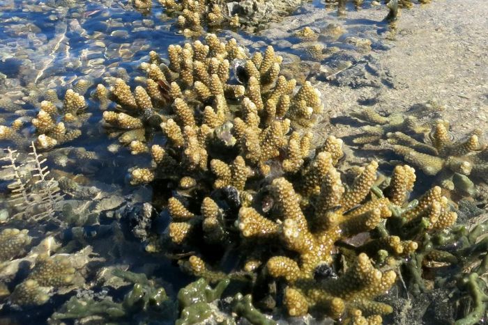
Intertidal Acropora corals in the Kimberley are exposed to the air at low tides. (Verena Schoepf)

The research also found that massive corals had a better chance of surviving and recovering from bleaching than branching corals.

The current strong El Niño weather pattern in the Pacific puts many coral reefs at risk of severe bleaching, and recent weather predictions show that the Kimberley region might be particularly affected in 2016.

“With the third global bleaching event underway, it has never been more urgent to understand the limits of coral thermal tolerance in corals,” Professor McCulloch said.

Co-authors on the study also included Dr Michael Stat from the Trace and Environmental DNA (TrEnD) Laboratory at Curtin University and Dr James Falter from the Coral CoE at The University of Western Australia.

Related Links:

Paper:
Limits to the thermal tolerance of corals adapted to a highly fluctuating, naturally extreme temperature environment, by Verena Schoepf, Michael Stat, James L. Falter and Malcolm T. McCulloch is published in the journal Nature Scientific Reports


The $30 million Kimberley Marine Research Program is funded through major investment supported by $12 million from the Western Australian government’s Kimberley Science and Conservation Strategy co-invested by the WAMSI partners and supported by the Traditional Owners of the Kimberley.

Category:

Kimberley Marine Research Program

Field trip finds turtle and fish food abundant in Bardi Jawi country

A team of CSIRO and UWA researchers has just returned from a 10-day field trip to Bardi Jawi country, where they took the last of their seagrass, seaweed and microalgae measurements for a WAMSI project that will determine the current state of the area’s primary food source for rabbitfish and green sea turtles.

The team worked with the Bardi Jawi Rangers on Tallon Island (Jalarn) and Sunday Island (Iwany) off the Dampier Peninsular in the Kimberley. They measured the growth of seagrass and macroalgae on the reef platforms, and microalgae in the sand that forms the beaches. These are all primary producers that sustain food webs, and the area’s seagrass is a key food source for fish and turtles that are important for the Bardi Jawi.

Preparing for seagrass tethering study (Mat Vanderklift)

Some seagrass was punched with holes to measure growth — researchers measure how far the holes have moved after a week to see how much the grass has grown. Other seagrass was collected, pegged out, measured and returned to the seagrass meadow for a 24 hour period before being measured again to determine how much had been eaten.

CSIRO’s Mat Vanderklift, who is also working on green sea turtle tagging as part of another WAMSI project, said the findings were providing the first comprehensive picture of productivity and seasonality of seaweed, seagrasses and microalgae in the Kimberley.

“Through collaboration with the Bardi Jawi Rangers we have been able to build up detailed seasonal understanding of seagrass productivity through the year,” Dr Vanderklift said. “We also have a better understanding of the importance of this productivity for green turtles and herbivorous fish like rabbitfish.”

Seagrass habitat with a sea cucumber in the Bardi Jawi IPA (Mat Vanderklift)

“The key findings are that the main plants that we have found in the lagoon habitats (the seagrasses Thalassia and Enhalus, and the large brown algae Sargassum) all have high growth rates throughout the year, with growth rates sometimes exceeding a centimetre a day,” Dr Vanderklift said. “We have also found that microscopic algae are very abundant in some places, but not everywhere, and bacteria are particularly abundant in the sediment under mangroves and seagrasses.”

The project has found that herbivores are abundant in the area and that they eat a lot of the seagrass. One of the main herbivores in the area, rabbitfish (Siganus lineatus), is a highly sought after food source by the Bardi Jawi people.

The project is also finding that the seagrasses are living at the limit of their temperature tolerances and further studies of their vulnerability to climate change are needed.

James McLaughlin on Jologo beach talking about microalga with kids from One Arm Point Remote Community School. (Mat Vanderklift)


“Collaborations with the Bardi Jawi Rangers have added enormous value to the research,” Dr Vanderklift said. “We have been able to exchange knowledge and learn from each other – for example, the discovery of the importance of seagrass to rabbitfish would not have happened if we had not worked closely together. The success of this project is because of the collaboration we have built together.”

The latest trip also gave the researchers an opportunity to present to children from the local One Arm Point Remote Community School.

James McLaughlin wowed the high school “Bush Rangers” with real-life chemistry on the beach, while Mat Vanderklift talked to dozens of excited children about turtles at their Culture Day. “They all enjoyed the game of guessing where the tagged turtles had travelled,” he said.

The project group is now completing the measurements and analysing the data, and will return to show the community and the rangers the results next year, with the aim of informing the ranger’s activities under their Indigenous Protected Area management plan.

Josh Setting up Benthic chamber module. (Mat Vanderklift)


The $30 million Kimberley Marine Research Program is funded through major investment supported by $12 million from the Western Australian government’s Kimberley Science and Conservation Strategy co-invested by the WAMSI partners and supported by the Traditional Owners of the Kimberley.

Category:

Kimberley Marine Research Program

New research determines dredging effects on seawater quality

WAMSI Dredging Science Node researchers have, for the first time, quantified dredging effects on seawater quality conditions, which is critical to realistic testing in the laboratory.

The literature review along with the examination of some large environmental monitoring datasets from recent dredging projects provided by Chevron Australia, Woodside Energy and Rio Tinto Iron Ore, have been published in PLOS ONE.

Lead author of the paper: Temporal Patterns in Seawater Quality from Dredging in Tropical Environments, Dr Ross Jones from the Australian Institute of Marine Science (AIMS), said bringing the current knowledge together means previous laboratory testing can be appraised on the relevance of the pressure fields used, and that future testing, including the next phase of WAMSI’s dredging science program, now has a peer reviewed reference.

“The reviews of existing monitoring datasets from industry have allowed us to more accurately quantify how dredging affects seawater quality conditions temporally and spatially,” Dr Jones said. “This information is critical to test realistic exposure scenarios.”

The research found that dredging effectively alters the overall probability distributions of fine temporal scale turbidity and light changes, increasing the frequency of extreme values and dampening the probability distribution.

“When averaged across the entire baseline and dredging phases separately for the three Pilbara dredging projects, turbidity values increased by 2–3 fold but when examined by the IDF analysis across baseline and dredging periods, dredging increased the intensity (magnitude) of turbidity peaks by over an order of magnitude, generated peaks that lasted five times longer than the baseline period, and may cause peaks to occur up to three times more frequently,” Dr Jones said.

The second prominent and characteristic feature of the seawater quality conditions during the dredging programs were the low light, or ‘daytime twilight’ periods. Such conditions are well known to be associated with wind and wave events.

“One of the objectives of this analysis was to provide a temporal analysis of seawater quality to allow the design of more realistic experiments examining the effects of sediments on tropical marine organisms (corals, seagrasses, sponges ascidians etc),” Dr Jones said. “The analysis has provided a matrix of empirical data of seawater quality (turbidity and light levels) which effectively captures the entire range of likely seawater quality conditions associated with dredging in a reefal environment.”

“Collectively this information could contribute to the development of seawater quality thresholds for dredging projects and ultimately improve the ability to predict and manage the impact of future projects,” Dr Jones said.

R. Jones, R. Fisher, C. Stark, P. Ridd (October 2015) Temporal Patterns in Seawater Quality from Dredging in Tropical Environments PLOS DOI: 10.1371/journal.pone.0137112

The WAMSI Dredging Science Node is made possible through $9.5 million invested by Woodside, Chevron and BHP as environmental offsets. A further $9.5 million has been co-invested by the WAMSI Joint Venture partners, adding significantly more value to this initial industry investment. The node is also supported through critical data provided by Chevron, Woodside and Rio Tinto Iron Ore.

Category:

Dredging Science

Indian Ocean creates its own flow-on effect

New research led by CSIRO has described how heavy rainfall caused the top layer of the southeast Indian Ocean to be less salty, creating a barrier layer which trapped the heat during the deadly marine heatwave – La Niña and the ‘Ningaloo Niño’ of 2010-11. The result was a larger volume of warmer water being driven by a stronger current down the WA coastline.

The finding, which is part of WAMSI’s Kimberley Marine Research Program, provides further scientific knowledge to help predict responses to climate change, and adds another layer to consider when forecasting extreme marine heatwave events.

Surface salinity anomalies (psu) derived from gridded Argo product (relative to 2005–2012 monthly climatology) in February 2011.

According to CSIRO’s physical oceanographer Dr Ming Feng, the change in salinity levels on the top 100 metres of the ocean also raises more questions, such as how it will affect some marine species.

“In the past we have followed the Pacific Ocean climate closer in evaluating WA marine environment. We haven’t focused much attention on the Indian Ocean variables and the effect on the WA environment,” Dr Feng said. “It seems that the more we find out about the Indian Ocean, the more we realise it operates very differently to any other ocean on earth.”

The Leeuwin Current, the eastern boundary current of the southeast Indian Ocean, carries warm fresh tropical water southward along the west coast of Australia. The current is stronger in Australia’s winter and weaker in summer; it also tends to be stronger during La Niña events.

Surface currents in the Indian Ocean during austral summer, adapted from Schott et al. [[1]] and Menezes et al. [[2]]. The background shading shows the sea surface temperature anomalies (°C) in February 2011 derived from the Argo float data. ITF: Indonesian throughflow; LC: Leeuwin Current; SJC: South Java Current; SEC: South Equatorial Current; SECC: South Equatorial Counter Current; SC: Somali Current; NMC: Northern Monsoon Current; NEMC: North East Madagascar Current; SEMC: South East Madagascar Current; SICC: South Indian Countercurrent.

The latest research compared salinity observations at the CSIRO/Integrated Marine Observing System (IMOS) Rottnest National Reference Station collected during the past 60 years. Analysis of these observations revealed the unusual, but significant, freshening of the ocean’s top layer during 2010-2011.

Dr Feng suspects this may not be the first or last time we experience such an event.

“Something similar probably happened in 1999/2000, so it might happen in the future, especially as we experience more frequent warmer conditions,” he said.

It’s thought that the change in salinity can take a few years to return to normal but the El Niño forecast for 2015, which was to result in a weakening in the Leeuwin Current and cooler water temperatures along the coast of WA, has not rung true.

“Typically we should be experiencing cooler temperatures off the west coast this year but the temperatures have still been warmer than normal, so this is an unusual year, and it shows we don’t fully understand the impact of the Indian Ocean,” Dr Feng said.

Ming Feng, Jessica Benthuysen, Ningning Zhang and Dirk Slawinski (October 2015) Freshening anomalies in the Indonesian throughflow and impacts on the Leeuwin Current during 2010–2011 Research Letters DOI: 10.1002/2015GL065848

The $30 million Kimberley Marine Research Program is funded through major investment supported by $12 million from the Western Australian government’s Kimberley Science and Conservation Strategy co-invested by the WAMSI partners and supported by the Traditional Owners of the Kimberley. 


Category:

Kimberley Marine Research Program

Kimberley reefs based on ancient history

WAMSI’s Kimberley Marine Research Program has provided the first definitive evidence that the region’s fringing coral reefs are long lived features growing over a two-billion-year-old land surface recording changes through post-glacial time and dispelling the theory that the reefs are thin veneers over bedrock.

The findings, published in the Australian Journal of Maritime and Ocean Affairs, make significant inroads into understanding the poorly known coral reefs of the Kimberley in an area that is considered an internationally significant ‘biodiversity hotspot’.

Co-author of the paper, Curtin University’s Mick O’Leary, said the project is working to determine just how unique the Kimberley reef system is.

“We hope to establish whether Kimberley reef morphology conforms to established geomorphic models, like the Great Barrier Reef,” Dr O’Leary said. “It may be that the reefs have developed their own distinctive morphologies driven by extreme environmental conditions, like the massive 11 metre tides that are unique to the Kimberley.”

 The research team used a combination of remote sensing, sub-bottom profiling and associated sedimentological work to produce a regional geodatabase of coral reefs and to determine the internal architecture and growth history of the coral reefs over the last 12,000 years.

More than 860 nearshore reefs were mapped from Cape Londonderry to Cape Leveque with a total of 30 reefs studied in detail and their substrates documented across the Kimberley Bioregion.

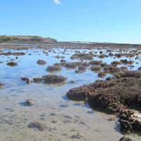
The prevalence of rhodolith dominated substrates on high intertidal reefs (both planar and fringing reefs) contrasts with the more coral dominated fringing reefs, with inner to mid-shelf planar reefs having some shared attributes with these contrasting categories.

Satellite images used to map intra-reef geomorphology and associated substrates for the targeted reefs of this study:

 (a) Bathurst and Irvine Islands; (b) Cape Londonderry; (c) Montgomery Reef; (d) Maret Island; (e) Adele Reef; (f) Long Reef; (g) Molema Island; and (h) Tallon Island.


Over 294 km of sub-bottom profiling records were aquired from a representative suite of reefs to determine reef growth history.

Two seismic horizons were identified in the inshore reefs (Sunday Islands, Molema Island, Montgomery Reef and the Buccaneer Archipelago, where seismic calibration was available), marking the boundaries between Holocene reef (Marine Isotope Stage 1, MIS 1, last 12 ky) commonly 10 – 15 m thick, and MIS 5 (Last Interglacial, 120 ky; LIG) and Proterozoic rock foundation over which Quaternary reef growth occurred. In the offshore reefs of the Adele Complex, two additional deeper acoustic reflectors were identified (possibly MIS 7 and MIS 9 or 11)

SBP images of the NW channel bank complex associated with North Turtle Reef


The transition of reef building organisms was investigated by shallow coring (up to 6 m) providing the first subsurface sedimentary samples for the key types of reef found in the southern Kimberley.

The core study sheds considerable light on the growth history of the reefs and has shown that the inshore reefs are muddy in character, similar to the Cockatoo island fringing reef.

Adele Reef, offshore, is distinctly sandier in character. Radiocarbon dating showed that, like Cockatoo Island, reef growth initiated soon after the inner shelf was flooded (~10,000 years ago).

Early reef buildups are likely to be muddy with branching, plate, and massive corals. This is replaced on many reefs (particularly exemplified by Montgomery and Turtle Reefs) by coralline red algae (rhodoliths), small robust corals and coral rubble as reefs become intertidal at their surface.

Multibeam surveys of reef flats discovered a new reef morphotype, the “High Intertidal Reef” which are uniquely characterised by having reef flats that have a surface elevation that sits above the level mid-tide level. Typically reef flats sit at the level of mean low water spring tide.

Getting ready for coring with help from Bardi Jawi Rangers and Erin McGinty from KMRS.


The project’s findings have been integrated into a GIS based database called ‘ReefKIM’ which incorporates a wide range of datasets, including remote sensing images, bathymetric charts, site photos and many geological and biological datasets into one inclusive geodatabase.

The main purpose of ReefKIM is to compile various types and sources of reef and marine environment-related information, fostering data fusion and maximising the accessibility of important information to better understand the Kimberley reefs.

It is intended to provide researchers with an overview of essential information on the Kimberley reefs. It also constitutes a significant decision-support tool, providing managers and stakeholders with practical information for the implementation of their plans and will also help shape the direction of future management policies of the Kimberley region.

Crowdsourcing new information into ReefKIM (also known as the ‘citizen science’ approach) is a promising method for filling knowledge gaps and enhancing understanding of complex reef ecosystems.


Methodological scheme of data acquisition, processing, integration and storage for the Kimberley reef geodatabase (ReefKIM) (source: Kordi et al., 2016).


“Satellite image analysis has revealed that fringing reefs in the Kimberley bioregion grow very well and differ geomorphologically from middle-shelf planar reefs both inshore and offshore,” Dr O’Leary said.

 “The acoustic mid-shelf reef (Adele complex) profiles marked boundaries between Holocene reef (last 12,000 years) and MIS 5 (last 125,000 years) and an ancient Neoproterozoic rock (1,000 to 541 million years ago).

“Correlating the seismic data with the reef chronology determined in Cockatoo and Adele Island, it has been possible to highlight the evolution of multiple stages of reef building, stacked by repeated high sea levels (Adele, 3 stages, at least; Sundays Group, Buccaneer Archipelago and Montgomery Reef, 2 stages; some patch reefs, 1 stage).

“What we’ve found is that the foundation over which reef growth occurred is the two-billion-year-old land surface seen in many Kimberley islands composed of Neoproterozoic rocks. That confirms that Kimberley reefs are not thin growths over bedrock,” Dr O’Leary said.

The findings provides a better understanding of the Kimberley reefs and demonstrate their capacity to succeed in challenging environments while generating complex habitats to support diverse species.

Research Articles:

Collins, L.B., O’Leary, M.J., Stevens, A. M., Bufarale, G., Kordi, M., Solihuddin, T, 2015. Geomorphic Patterns, internal architecture and Reef Growth in a macrotidal, high turbidity setting of coral reefs from the Kimberley Bioregion. Australian Journal of Maritime & Ocean Affairs, Volume 7, Issue 1, pp 12-22. (open access from Nov 2017)

Moataz N. Kordia, Lindsay B. Collins, Michael O’Leary, Alexandra Stevensa (November 2015) ReefKIM: An integrated geodatabase for sustainable management of the Kimberley Reefs, North West Australia Ocean & Coastal Management doi:10.1016/j.ocecoaman.2015.11.004

The $30 million Kimberley Marine Research Program is funded through major investment supported by $12 million from the Western Australian government’s Kimberley Science and Conservation Strategy co-invested by the WAMSI partners and supported by the Traditional Owners of the Kimberley.

Category:

Kimberley Marine Research Program

James Price Point data to support Kimberley program

The Browse liquefied natural gas (LNG) Development investigated a major onshore processing facility 52 kilometres north of Broome on the Dampier Peninsula, in Western Australia’s Kimberley region. The Browse Joint Venture (JV) participants commissioned numerous studies and rigorous environmental management planning for the proposed onshore LNG development.

In April 2013, the Browse JV completed its technical and commercial evaluation of the proposed Browse LNG Development near James Price Point and determined that the development concept did not meet the company’s commercial requirements for a positive final investment decision.

Even so, the research and technical work gathered during this time represents a significant and comprehensive collection of unreleased information on the local areas’ marine environment including, habit and species assessments, aerial and vessel megafauna surveys as well as benthic and seagrass habitat surveys.  Woodside, on behalf of the Browse JV, has shared this data with WAMSI for the Kimberley Marine Research Program.

Proposed FLNG location in 2010

“The Browse JV has invested more than A$55 million in environmental research and studies, often in conjunction with leading academic and research organisations, to better understand the offshore marine environment in the vicinity of the three Browse gas fields,” Woodside’s Senior Vice President Projects, Steve Rogers said.

“By sharing our research and collaborating with WAMSI scientists, the valuable data collected over the past two decades can directly improve how the marine environment is managed,” Mr Rogers said.

WAMSI CEO Patrick Seares described the James Price Point data as key to helping the Kimberley Marine Research Program link information developed through its fieldwork focus further to the north, with more studies in the areas of Roebuck Bay and the Browse Basin.

“This enormous marine science program is all being done to improve the understanding and management of the Kimberley marine environment. The Browse JV data will allow us to fill in some of the gaps off the Dampier Peninsula and provide an even more complete picture to marine park and fisheries managers, traditional owners, regulators and future proponents,” Mr Seares said.

“We’ve been working to build both trust and the business case to support broader data sharing with industry on a number of fronts, including the agreements supporting the dredging science node and working with the energy sector on the IGEM system,” Mr Seares said.

“Opening up this data for the Kimberley program is another great step in that process and evidence that leading groups within the energy sector are increasingly working with the science sector to share knowledge. Long may it continue! ”

At this stage the raw data is limited to use for the WAMSI Kimberley Marine Research Program.

The $30 million Kimberley Marine Research Program is funded through major investment supported by $12 million from the Western Australian government’s Kimberley Science and Conservation Strategy co-invested by the WAMSI partners and supported by the Traditional Owners of the Kimberley.

Category: 

Kimberley Marine Research Program