Crowdsourcing for the Kimberley Marine Environments

By: Moataz Kordi (Curtin University)
The crowdsourcing data approach for information gathering has been used worldwide for a variety of purposes, from creating and sharing geographic information volunteered by individuals through common and freely available platforms such as Wikimapia and OpenStreetMap, to assisting in human crises situations through programs such as Ushahidi.
The crowdsourcing approach has also been employed in many scientific endeavours, including Geo-Wiki, with volunteers helping to improve the quality of global land cover maps.
 |
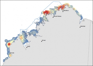
| Crowdsourcing data approach has facilitate the way researchers and managers receive information from the field. (Moataz Kordi) |
Recent studies have discussed the benefits of scientific research in open collaborative projects using the ‘crowd science’ or ‘citizen science’ approach.
As an example, community participation played a significant role in re-zoning the Great Barrier Reef Marine Park Authority (GBRMPA).
Also, volunteer involvement in the monitoring program Reef Watch, coordinated by the Conservation Council of South Australia for the sustainable management of marine ecosystems, has helped increase knowledge about the status of temperate reefs in South Australia.
Volunteer divers and snorkelers also recorded about 180 marine species in Victoria, Australia, through the monitoring initiative Reef Watch Victoria, developed by the Victoria National Parks Association and Museum Victoria to protect Victoria’s marine environment.
Another remarkable monitoring program called Eye on the Reef, managed by GBRMPA, in partnership with the Queensland Parks and Wildlife Service, enables visitors to the Great Barrier Reef to report reef observations though smartphones or tablets application. The data provide Marine Park managers and researchers with up-to-date information on current reef status.
 |
| Traditional owners and rangers have valuable information on the marine environment and they are willing to share their knowledge for the sake of conservation of this vital ecosystem (Tubagus Solihuddin) |
During field work in the Kimberley Bioregion for the Western Australian Marine Science Institution’s Geomorphology project, it was noticed that many people connected with the marine environment including the rangers, fishermen, pearl farmers, traditional owners, nature photographers and tourists, had valuable scientific information, such as site images, underwater videos and photos, and aerial photography of marine fauna and flora, including reefs.
The idea that a wide group within the Kimberley community were willing to share their valuable knowledge let to the development of ReefKIM, a similar crowdsourcing geodatabase in which researchers were able to compile existing spatial and non-spatial data, as well as collecting new data to complete information gaps.
This information has had a significant role in the verification of satellite images when reef habitats and substrates were being mapped. And all of the people we met were willing to share their knowledge for the sake of conservation of this vital ecosystem.
This demonstrated to us that crowdsourcing provides valuable opportunities for individuals to engage in activities with environmental purpose. So let us get together and share our valuable knowledge to protect our magnificent marine environment of the Kimberley.
Related papers:
- Bufarale G, Collins LB, O’Leary MJ, Stevens A, Kordi M, Solihuddin T (2016). Quaternary onset and evolution of Kimberley coral reefs (Northwest Australia) revealed by high-resolution seismic imaging. Journal of Continental Shelf Research, 123, 80–88 doi:10.1016/j.csr.2016.04.002
- Kordi, M.N., and O’Leary, M. (2016). Geomorphic classification of reefs in the north western Australia Shelf. Regional Studies in Marine Science, DOI 10.1016/j.rsma.2016.05.012.
- Kordi, M.N., and O’Leary, M. (2016) A Spatial Approach to Improve Coastal Bioregion Management of the North Western Australia. Ocean & Coastal Management, 127, 26-42 doi:10.1016/j.ocecoaman.2016.04.004
- Solihuddin T, O’Leary M, Blakeway D, Parnum I, Kordi M, Collins L (March 2016) Holocene reef evolution in a macrotidal setting: Buccaneer Archipelago, Kimberley Bioregion, Northwest Australia Coral Reefs DOI 10.1007/s00338-016-1424-1
- Kordi M.N., Collins, L.B., O’Leary M, Stevens A (November 2015) ReefKIM: An integrated geodatabase for sustainable management of the Kimberley Reefs, North West Australia Ocean & Coastal Management doi:10.1016/j.ocecoaman.2015.11.004
- Kordi M.N., Collins, L.B. and Stevens A. (2015). A Large Scale Geomorphological and Surficial Cover Map of Nearshore Reefs in the Kimberley Coast, WA. In Proceedings from Coast to Coast Conference 2014, Mandurah, Western Australia. ISBN-10: 0994357206 pp 15–20
- Collins, L.B., O’Leary, M.J., Stevens, A. M., Bufarale, G., Kordi, M., Solihuddin, T, 2015. Geomorphic Patterns, internal architecture and Reef Growth in a macrotidal, high turbidity setting of coral reefs from the Kimberley Bioregion. Australian Journal of Maritime & Ocean Affairs, Volume 7, Issue 1, pp 12-22. (open access from Nov 2017)
- Kordi, M.N., Collins, L.B., and Stevens, A. (2015). Geomorphic Patterns, Habitats and Substrates of Macrotidal Reefs from the Kimberley, North West Australia. In Proceedings from 2015 WAMSI Research Conference, Perth, Western Australia pp 72
The $30 million Kimberley Marine Research Program is funded through major investment supported by $12 million from the Western Australian government’s Kimberley Science and Conservation Strategy co-invested by the WAMSI partners and supported by the Traditional Owners of the Kimberley.


")


")


")


")

