On the Humpback Highway – One Ten East Log

One Ten East Logs from the IIOE-2 voyage aboard RV Investigator will be posted on the WAMSI website during the month long voyage.

Log from One Ten East

The RV Investigator is currently undertaking oceanographic research along the 110°E meridian off Western Australia as part of the second International Indian Ocean Expedition. The voyage is led by Professor Lynnath Beckley of Murdoch University and the research is supported by a grant of sea time on RV Investigator from the CSIRO Marine National Facility.

Date: June 12, 2019 Time:  1200 AWST
Latitude: 28°S Longitude: 113°E
Wind direction: SW Wind speed: 11 knots
Swell direction: SW 4-5 m Depth: 125 m
Air temperature: 18°C Sea temperature: 24°C
Notes: We heard humpback whales singing this morning. Indeed, what a lovely song it was!
On the Humpback Highway!
By Micheline Jenner AM and Curt Jenner AM
‘We’ve got whales!’
Excitedly, I was referring to the two blows just sighted only a couple of miles ahead of our small inflatable research vessel. With a pair of humpback whales in front and another two animals travelling behind us, moments later I yelled, ‘we are on the humpback highway!’
That was August 5th 1990 and this was the very first research trip of our thirty years of cetacean research in Western Australia. Now, from the deck of the RV Investigator we are plying the same waters along the west coast of Australia. A few hundred kilometres inshore, blows and breaches of humpback whales indicate the northern migration is on cue and underway, they are travelling to their tropical breeding grounds. Humpback whales have spent the austral summer in their Antarctic feeding grounds where they have gorged on krill, Euphausia superba–the keystone species of the Southern Ocean. Ready for 4-5 months on the breeding grounds, they have thick blubber layers, up to one-third of a metre.
The early birds travelling along the coast are the immature males. They will not have access to the females this year, but they know they have to migrate and they have to go somewhere! Learning the route and the successful technique of migrating north and south, without even engaging in the mating activity, is all part of the growing up process. Next on the northern migration are the immature females, the mature males and resting mature females (often with their soon to be separated yearlings) and then last, but not least, the pregnant whales make the journey north to give birth in warm, tropical coastal waters.
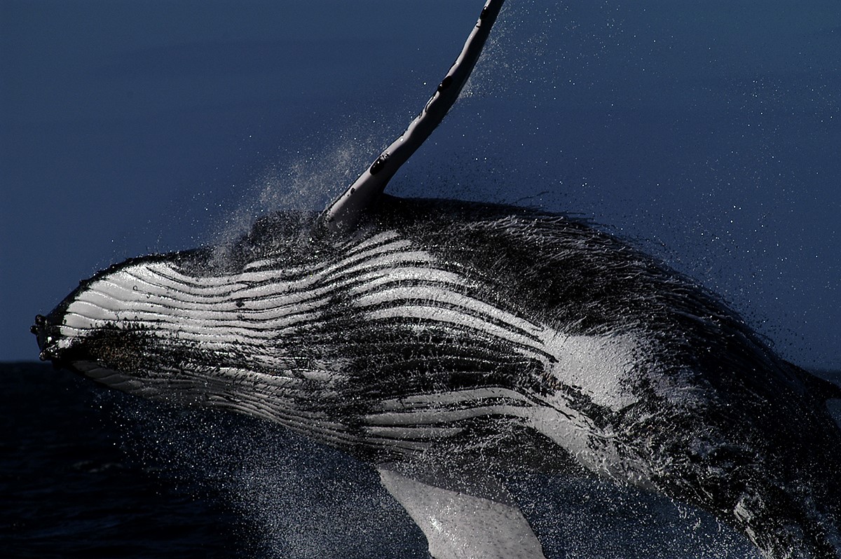
Humpback whales are renowned for their spectacular breaching displays. Leaping clear of the water, breaches can be interpreted as defensive, inquisitive or even playful behaviour. Photo: Micheline Jenner AM.
On our computer, as we are heading south towards Fremantle, the sonobuoys are revealing singing humpback whales. Seven years ago, when we first travelled this coast using this type of sophisticated listening equipment, we recorded a marvellous cacophony of humpback whale song–so boisterous and varied, we called it “Ningaloo Jamboree”. In the spirit of repeating surveys, we hope to record an “Abrolhos Jamboree” with all the beautiful trills, squeals, grunts and groans that humpback whales utter as they travel along the WA coastline.
Humpback whale song is sung by the males–one hypothesis poses that they are advertising their availability to the females during this breeding season. Having heard decades of humpback song ourselves, we can see why the female whales are swayed and the population is doing so well! Another hypothesis proposes that humpback whale song can also be used by “sentinels”, perhaps positioned at prominent landmarks like Northwest Cape, as a means of guiding their fellow humpback whales on their northward or southward migrations. After all, humpback whales make one of the longest migrations of any animals in the animal kingdom of around 13,000 km–a little help along the way might be necessary!
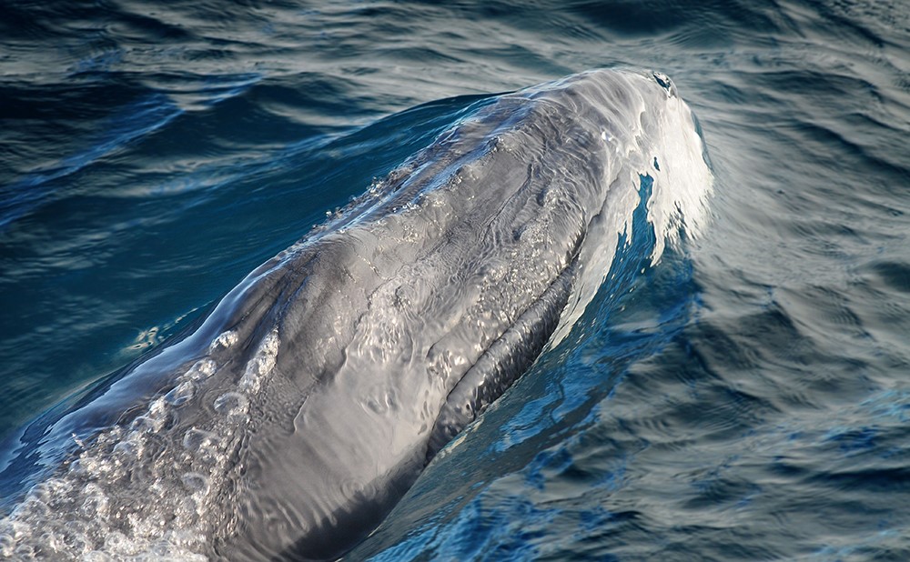
Newborn humpback whales are plentiful along the west coast of Australia. Photo: Micheline Jenner AM.
Humpback whales are flourishing population-wise and, particularly off Western Australia, are most likely near their pre-whaling numbers. With only 200-300 humpback whales left in 1962, it is delightful to see the crop of newborns and yearlings each year as the population steadily increases. With between 40-45,000 whales in the Western Australian population travelling the coast, we might see a large proportion of these whales on this journey. Photos of individual animals collected from RV Investigator will be added to our Centre for Whale Research Humpback Whale Photo-ID Catalogue, which now houses more than 8000 images of over 5500 individuals.
Vertical Microstructure Profiles – One Ten East Log

One Ten East Logs from the IIOE-2 voyage aboard RV Investigator will be posted on the WAMSI website during the month long voyage.

Log from One Ten East

The RV Investigator is currently undertaking oceanographic research along the 110°E meridian off Western Australia as part of the second International Indian Ocean Expedition. The voyage is led by Professor Lynnath Beckley of Murdoch University and the research is supported by a grant of sea time on RV Investigator from the CSIRO Marine National Facility.

Date: June 11, 2019 Time:  1200 AWST
Latitude: 23°S Longitude: 112°E
Wind direction: SSW Wind speed: 19 knots
Swell direction: SW 3.5 m Depth: 1071 m
Air temperature: 20°C Sea temperature: 24°C
Notes: The third Triaxus section has been completed. RV Investigator is bolting for the barn!


Vertical Microstructure Profiles

Dr Helen Phillips

Waves breaking on the beach are a familiar sight to many people. Ocean swells, generated by storms out at sea, constantly move toward the coast. As the swell waves move into shallow water, they steepen and then finally break. The same thing happens below the surface of the ocean.

Waves inside the ocean are known as internal waves. Instead of existing at the boundary between air and ocean, they exist between layers of water of different density – warmer, lighter surface waters lie above colder, denser waters. Internal waves ride these density layers, and often steepen and break. Their breaking causes mixing inside the ocean, which is vital for distributing heat.

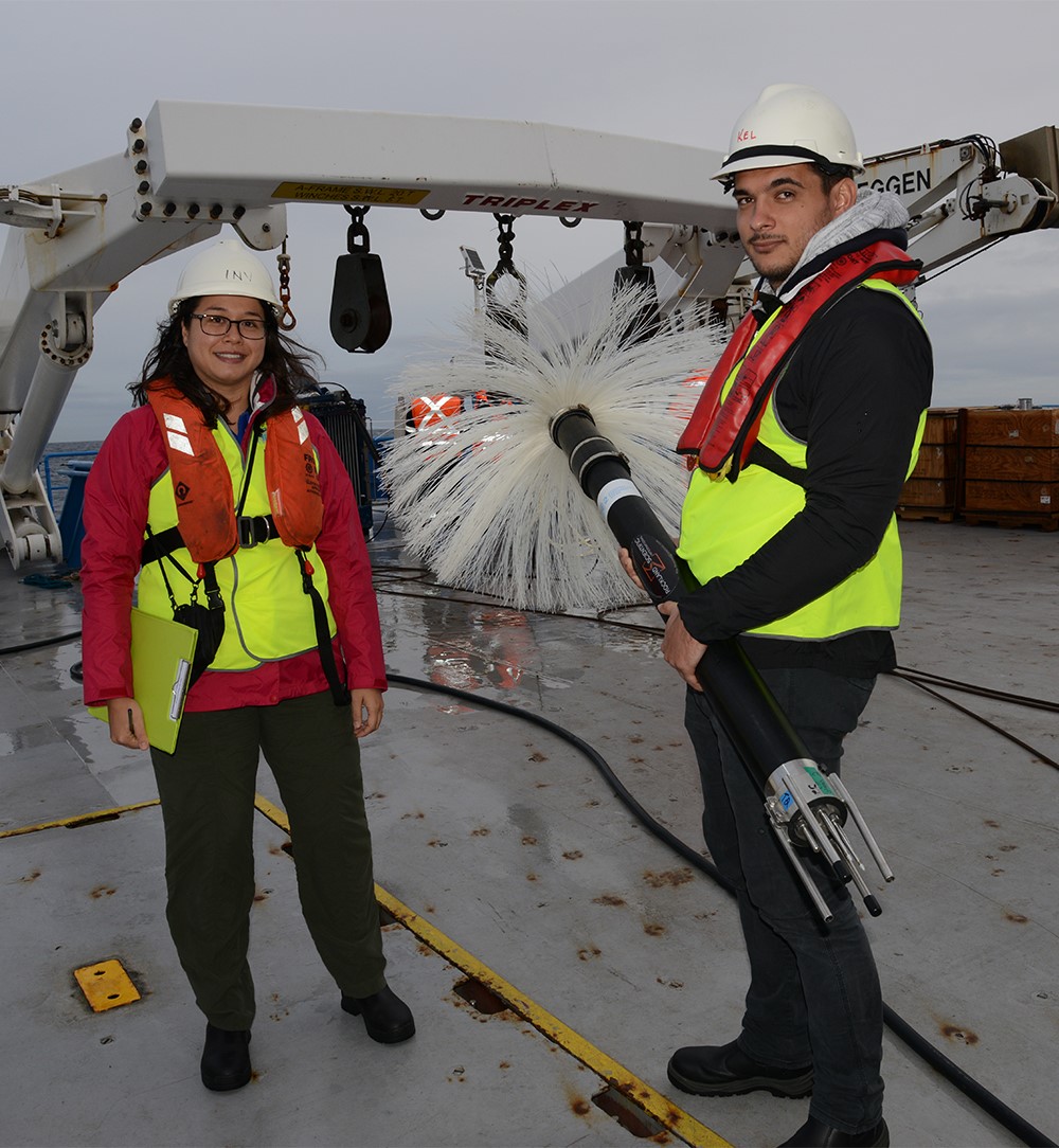
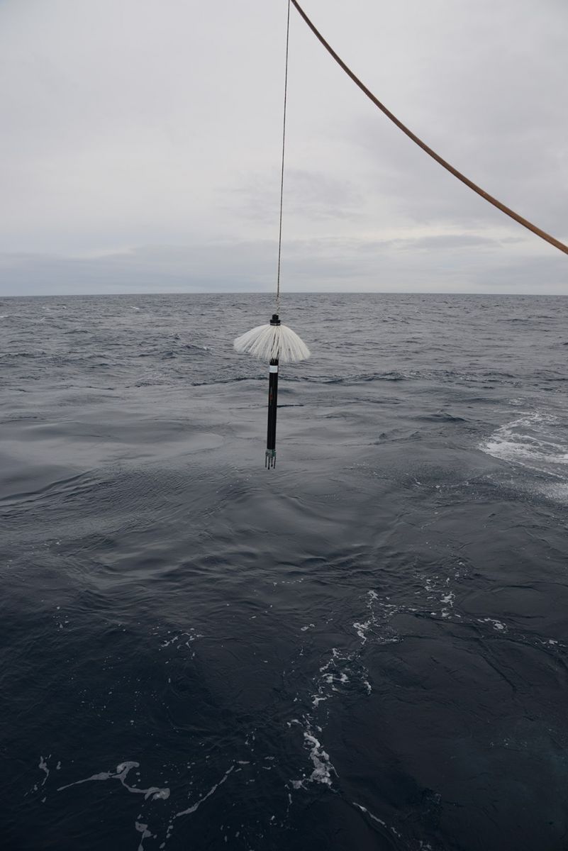
We measure ocean mixing with a Vertical Microstructure Profiler (VMP), also affectionately known as the “toilet brush”. The VMP has very sensitive probes that measure the small changes in ocean temperature and velocity that are caused by breaking internal waves. The mixing rate not only tells us how fast heat moves between the surface and the deep ocean, but also how rapidly nutrients can be brought to the surface to supply vital ingredients for the plankton at the base of the marine food chain.

Dr Jessica Benthuysen (AIMS) and Maxime Marin (PhD student University of Tasmania) prepare to deploy the VMP which measures small changes in ocean temperature and velocity caused by internal waves. Photo: Micheline Jenner AM.


The VMP, also known as the “toilet brush”, has been deployed from the stern of RV Investigator at each of the twenty stations on the 110°East line, providing vital understanding of ocean mixing and heat distribution in the south-east Indian Ocean. Photo: Micheline Jenner AM.


Be sure to follow the daily posts of our Log from One Ten East at https://iioe-2.incois.gov.in and www.wamsi.org.au

Mapping the Ocean’s Plankton: One Ten East log

One Ten East Logs from the IIOE-2 voyage aboard RV Investigator will be posted on the WAMSI website during the month long voyage.


Log from One Ten East

The RV Investigator is currently undertaking oceanographic research along the 110°E meridian off Western Australia as part of the second International Indian Ocean Expedition. The voyage is led by Professor Lynnath Beckley of Murdoch University and the research is supported by a grant of sea time on RV Investigator from the CSIRO Marine National Facility.

Date: June 07, 2019 Time:  1200 AWST
Latitude: 15°S Longitude: 111°E
Wind direction: NE Wind speed: 16 knots
Swell direction: NE 1m Depth: 5704 m
Air temperature: 28°C Sea temperature: 27°C
Notes: Towing the Triaxus undulating CTD across the East Gyral Current all day.


Mapping the Ocean’s Plankton

By Prof Andrew Jeffs

Oceans really are a microbial soup with just one litre of seawater containing 30,000–40,000 different types of microbes. Collectively these microbes make up 90% of life in the ocean by weight. They are the basis of food energy for ocean ecosystems and generate about half of the oxygen we breathe. Despite the huge importance of these microbes we know relatively little about their distribution and abundance in our oceans, and how this is changing. This is because they are microscopic and difficult to identify. However, advanced molecular genetic and computer cataloguing methods have progressed such that samples of seawater can be easily tested to identify all the resident organisms from their DNA signals.

A group of marine scientists and keen sailors now collect samples from around the world and contribute them to Plankton Planet Initiative, a global endeavour to map the world’s plankton to assess the biological health of our oceans. During the International Indian Ocean Expedition-2 110°East voyage, we are collecting daily samples along the 110°E line to contribute to this initiative.


Prior to deployment from RV Investigator, Prof Andrew Jeffs (University of Auckland) holds a microzooplankton net. Aimee van de Reis (PhD student, University of Auckland) holds the cod end, where the small plankton is collected. Photo: Micheline Jenner.


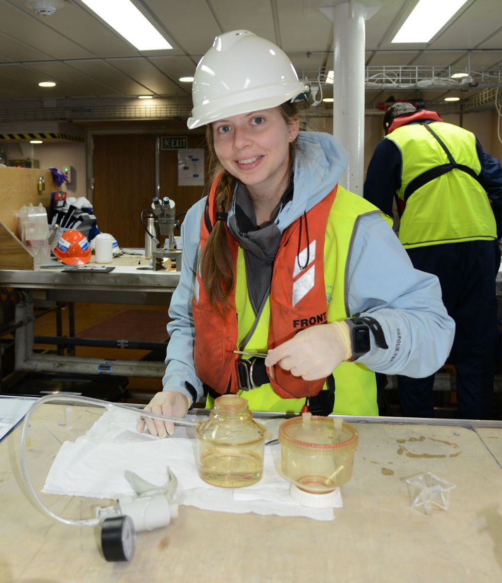
Aimee van de Reis (University of Auckland) filters the microzooplankton collected in the cod end of the net. Photo: Micheline Jenner.


Be sure to follow the daily posts of our Log from One Ten East at https://iioe-2.incois.gov.in and www.wamsi.org.au

Triaxus – One Ten East log

One Ten East Logs from the IIOE-2 voyage aboard RV Investigator will be posted on the WAMSI website during the month long voyage.


Log from One Ten East

The RV Investigator is currently undertaking oceanographic research along the 110°E meridian off Western Australia as part of the second International Indian Ocean Expedition. The voyage is led by Professor Lynnath Beckley of Murdoch University and the research is supported by a grant of sea time on RV Investigator from the CSIRO Marine National Facility.


Date: June 08, 2019

Time:  1200 AWST

Latitude: 18°S

Longitude: 111°E

Wind direction: W   

Wind speed: 5 knots

Swell direction: SSW 2m, S 1m

Depth: 4938 m

Air temperature: 23°C

Sea temperature: 26°C

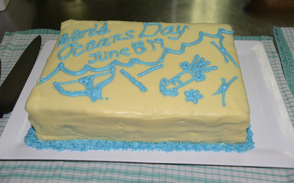
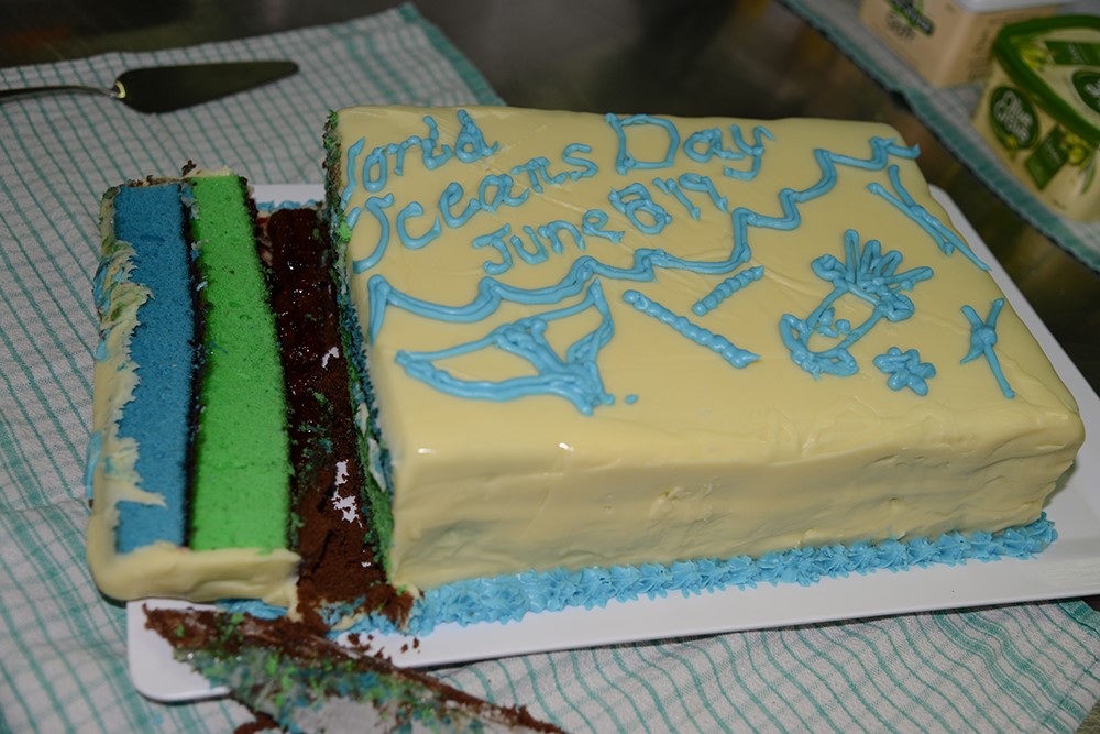
Notes: It’s World Oceans Day 2019! We had a special lunch in the marine-themed decorated mess. Dessert was a stratified layer cake complete with blue oceanic water, green chlorophyll maximum layer and the deep, dark ocean of chocolate! The students are now presenting their “3 minute thesis” about their research.


Triaxus

By Dr Helen Phillips

The ocean is never still. It warms by day and cools by night. Winds stir up the surface, mixing warmer surface waters with cold, deeper ones. Ocean currents bring waters from other regions and ocean eddies carry whole biological communities within their centres far from where they were first trapped inside the eddies.

RV Investigator moved slowly along the 110° East line because there were so many measurements to make at each station and they all took time. One station per day is what we could achieve to capture the physical, chemical and biological information we need to understand the major changes since the 1960s.

The rapid changes are also important and we use Triaxus to map these in a few places where we know there are fast currents with strong changes in water properties across them. Triaxus flies like a plane through the ocean, towed along behind the ship. It dives from the surface to 300 m depth and back to the surface in around seven minutes. As it flies, controlled by the electronics engineer on board, it measures ocean temperature, salinity, oxygen, nutrients and biological measurements. These variables can tell us how life in the ocean is influenced by ocean currents.

The focus for our Triaxus measurements are eastward currents called the Eastern Gyral Current and the South Indian Countercurrent. They carry waters from the Indonesian Seas and across the Indian Ocean into the coastal waters of Western Australia. The fisheries of WA depend on the nutrients supplied by these currents. Our measurements will help us understand what drives them and how they might change with global warming.


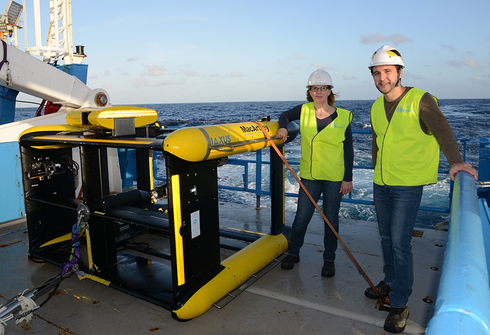
Dr Helen Phillips (University of Tasmania) and Earl Duran (University of New South Wales) eagerly awaiting deployment of the Triaxus so that they can analyse the data collected across the Eastern Gyral Current. Photo: Micheline Jenner AM.


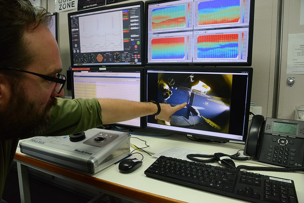
From the Operations Rooms on board RV Investigator Jay McGlashan (MNF Technical Support) monitors the Triaxus while it is collecting a myriad of oceanographic data along the Triaxus section (coloured graphs). Jay is pointing to the on board live-streamed camera feed. Photo: Micheline Jenner AM.


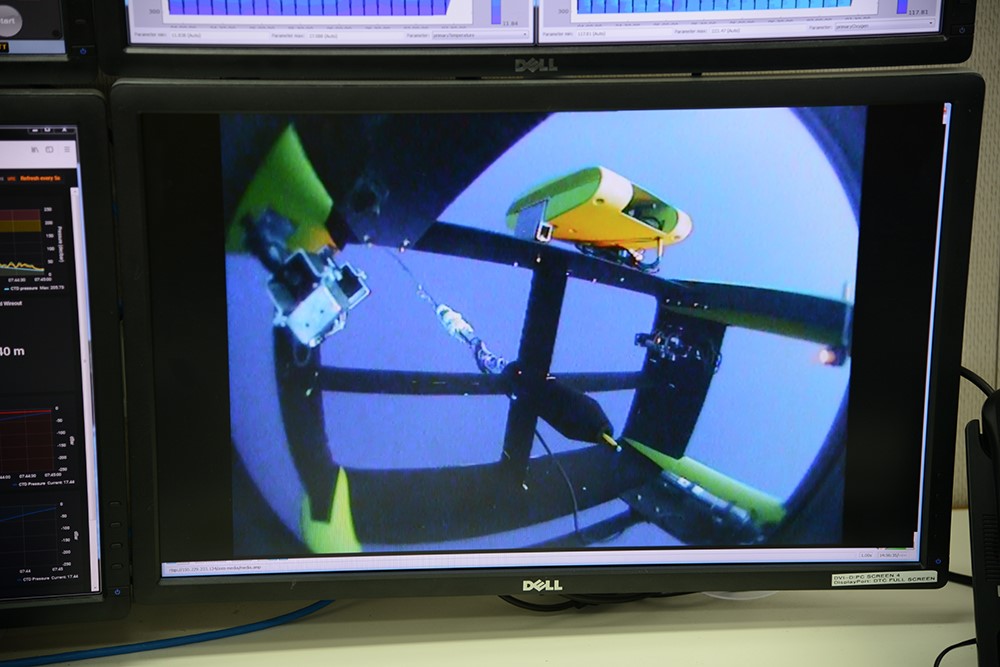
A camera’s eye view from aboard the Triaxus as it travels within the water column between the surface and 300 metres during the deployment. Photo: Micheline Jenner AM.


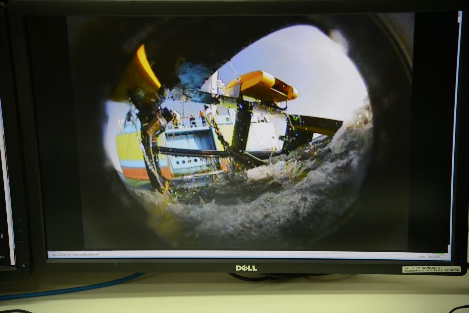
As the Triaxus comes to the surface for retrieval, in the camera the expert deck crew can be seen on the aft deck of RV Investigator. Photo: Micheline Jenner AM.


Be sure to follow the daily posts of our Log from One Ten East at https://iioe-2.incois.gov.in and www.wamsi.org.au


Drifters and Floaters – One Ten East log

One Ten East Logs from the IIOE-2 voyage aboard RV Investigator will be posted on the WAMSI website during the month long voyage.


Log from One Ten East

The RV Investigator is currently undertaking oceanographic research along the 110°E meridian off Western Australia as part of the second International Indian Ocean Expedition. The voyage is led by Professor Lynnath Beckley of Murdoch University and the research is supported by a grant of sea time on RV Investigator from the CSIRO Marine National Facility.


Date: June 10, 2019

Time:  1200 AWST

Latitude: 22°S

Longitude: 112°E

Wind direction: SW 

Wind speed: 14 knots

Swell direction: SW 4-5 m

Depth: 4946 m

Air temperature: 22°C

Sea temperature: 25°C

Notes: Currently planning to tow the Triaxus for section 3, in a beautiful rolling swell.


Drifters and Floaters

By Joel Cabrié and Prof Lynnath Beckley

During voyage IN2019_V03 we have deployed 14 weather buoys in the south-east Indian Ocean for the Australian Bureau of Meteorology and the American National Oceanic and Atmospheric Administration.

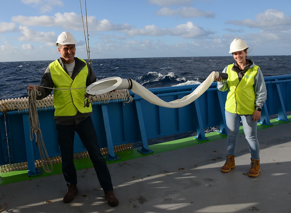
Meteorological drifting buoys are autonomous platforms that are typically deployed from ships to collect and report basic meteorological measurements. These platforms, as the name implies, drift with the near-surface currents to help fill otherwise data-sparse areas. The style of drifting buoy that is deployed by most meteorological and oceanographic agencies is a spherical buoy (SVP) fitted with a holey-sock drogue that forces the buoy to follow the path of currents near the surface, from which an estimate of the Lagrangian current can be deduced. The Bureau of Meteorology use an SVP-B buoy which measures atmospheric pressure in addition to sea surface temperature and Lagrangian current. A SVP-B buoy is distinguishable from an SVP buoy by a small stub mast on top of the buoy that houses the pressure port.

The main deployment areas for the Bureau of Meteorology are the Indian and Southern Oceans to maximise the benefit to the Bureau’s operations, whilst the Tasman Sea benefits from buoys deployed by MetService, New Zealand. The Bureau currently maintains a fleet of between 25-30 buoys in the Indian and Southern Oceans as part of their contribution to the international drifting buoy program of around 1,450 buoys.

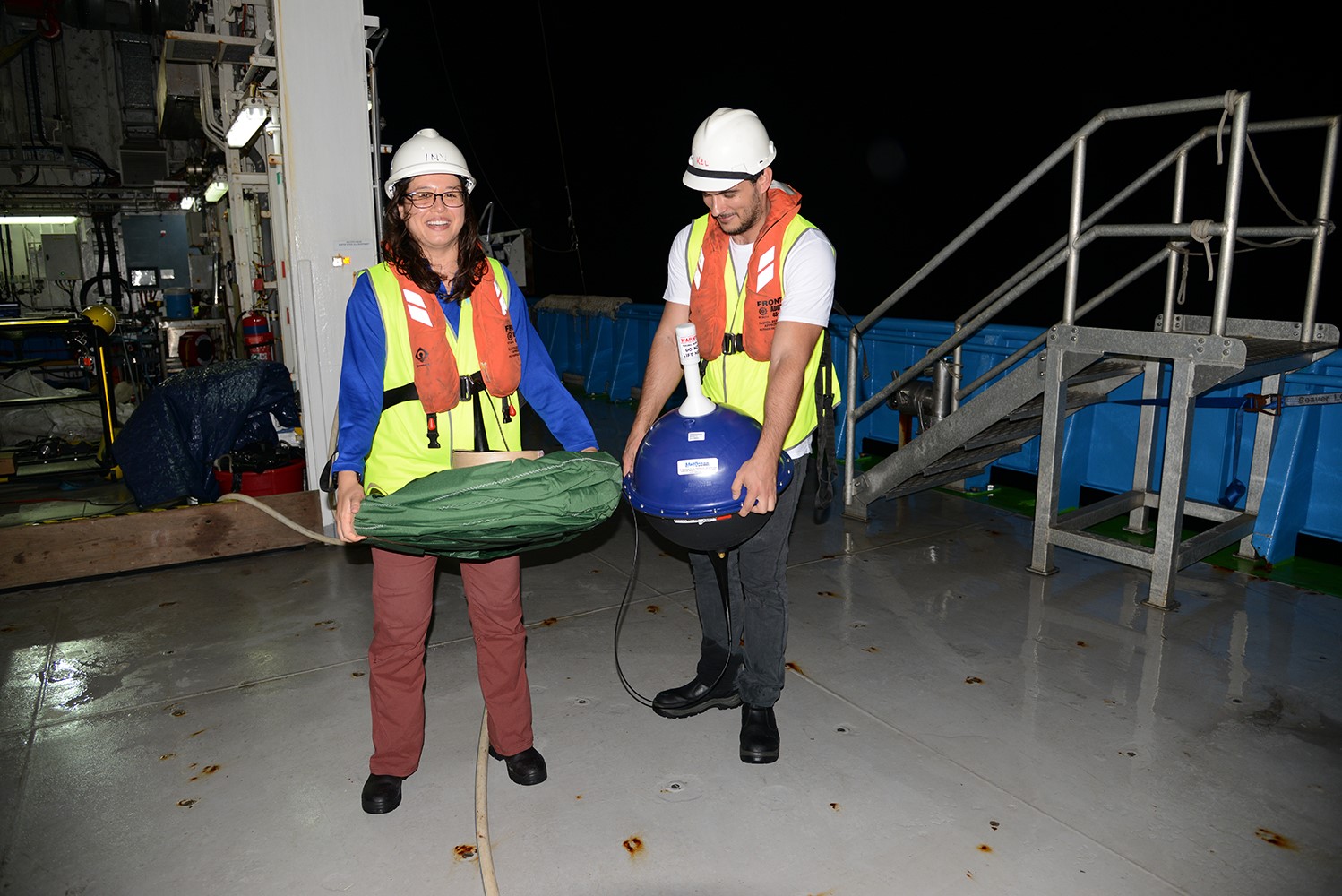
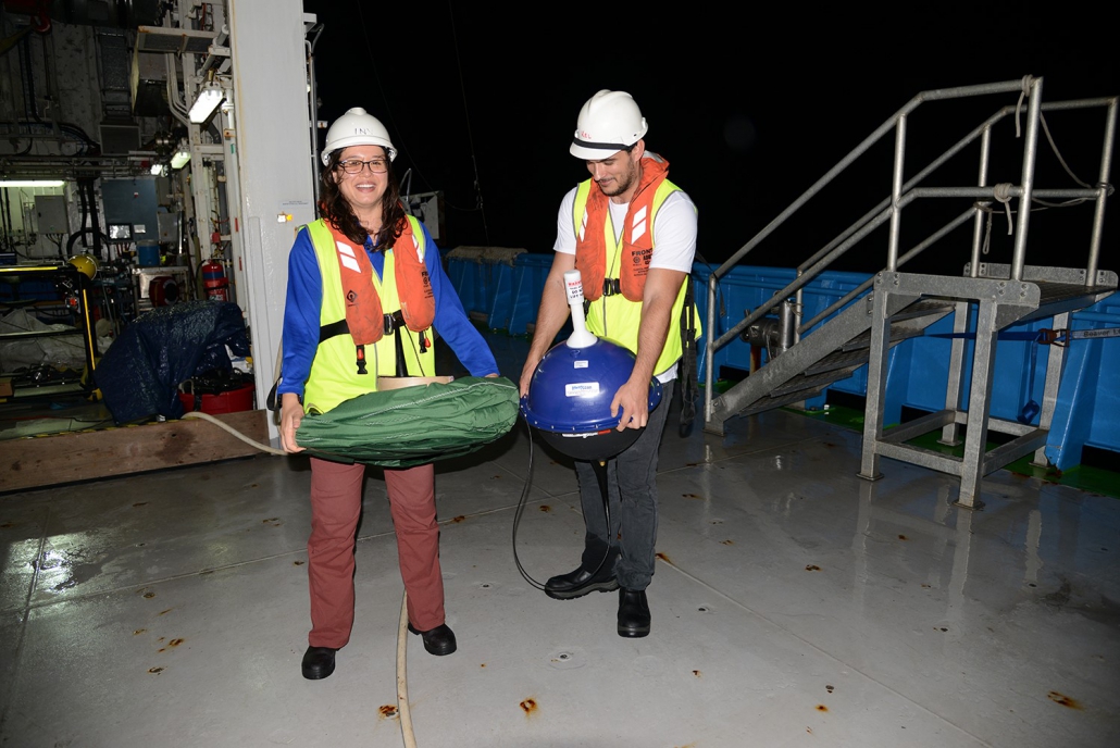
Prior to deployment, on the aft deck of RV Investigator, Dr Jessica Benthuysen (AIMS) holds the drogue, while Maxime Marin (PhD student University of Tasmania) holds the floating buoy of this drifter. Photo: Micheline Jenner AM.


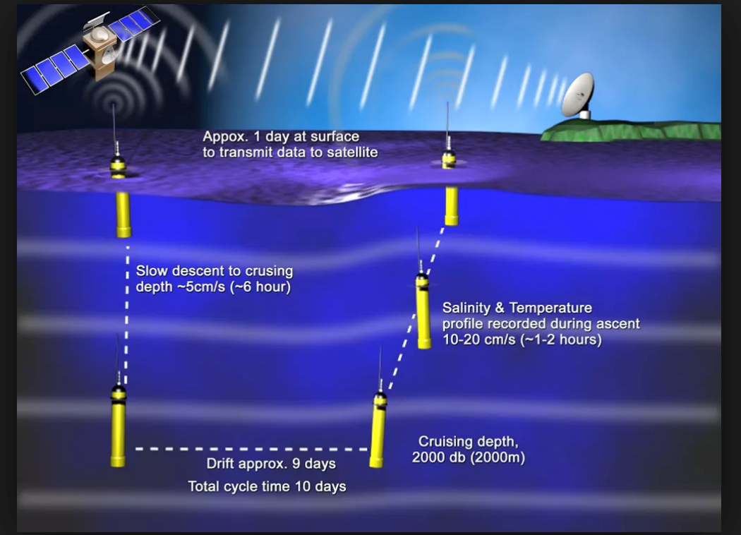
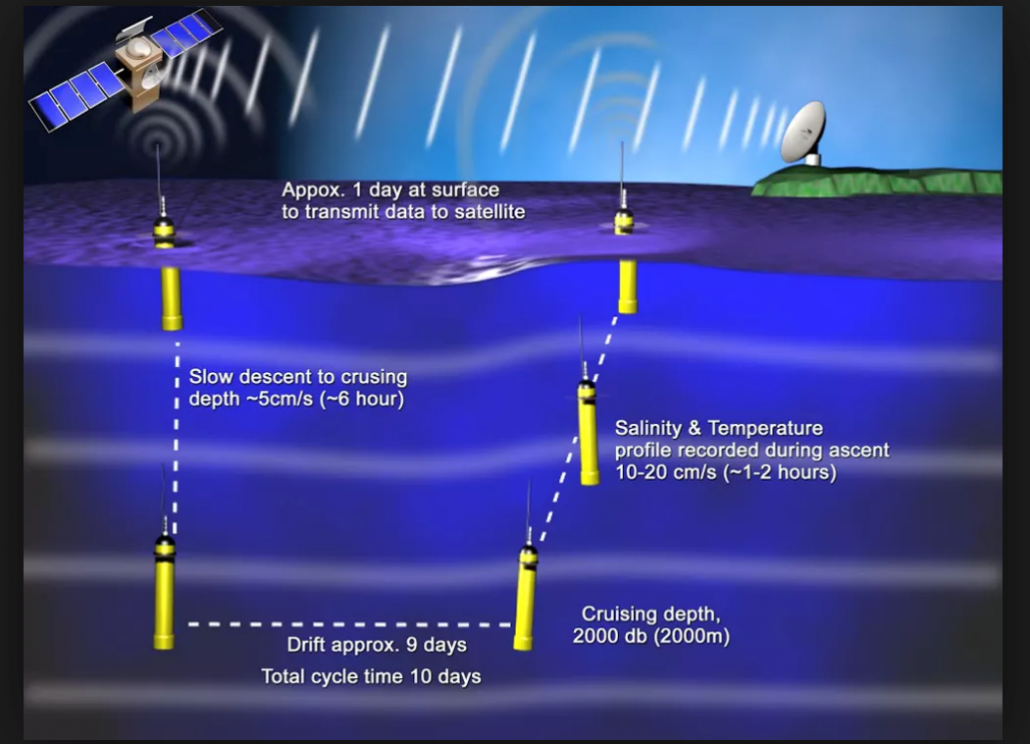
On our 110° East voyage we have also deployed an ARGO float for Australia’s Integrated Marine Observing System (IMOS). These robotic floats have revolutionized oceanography as they are capable of autonomously measuring the temperature and salinity profile in the ocean down to 2,000 m and transmitting this information back to base by satellite each time the float returns to the surface. There is a large international fleet of nearly 4,000 floats operating globally in all oceans providing vital information to oceanographers who monitor and model our blue planet. http://imos.org.au/facilities/argo/.


This schematic diagram shows the passage of an ARGO float as it progresses through its 10-day data collection cycle. Source: IMOS.


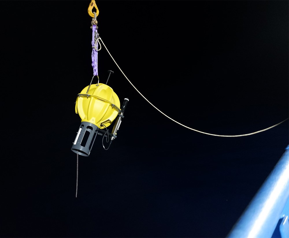
During our voyage we have also assisted our Japanese colleagues at the JAMSTEC agency in Tokyo by deploying two APEX deep ARGO floats for them. Remarkably, these round glass floats can monitor the deep ocean down to 6,000 m. However, just getting them to the RV Investigator was a complicated process as they had to be air-freighted from Tokyo to Sydney and then they crossed the Nullarbor on the back of a truck, making it to the Port of Fremantle just in time to be loaded on the RV Investigator! The first results from these floats are available at www.jamstec.go.jp/ARGO/argo_web/argo/?page_id=31&lang=en.


One of two APEX deep ARGOT floats deployed for the Japanese agency JAMSTEC. Photo: Karlie McDonald.


Be sure to follow the daily posts of our Log from One Ten East at https://iioe-2.incois.gov.in and www.wamsi.org.au

WAMSI Dredging Science Shortlisted for Environmental Excellence Award

The Western Australian Marine Science Institution’s Dredging Science Node has been shortlisted for WA’s Environmental Excellence awards.

The WAMSI Dredging Science Node (DSN) is among four projects identified by the Department of Mines, Industry Regulation and Safety’s 2019 Golden Gecko Award for Environmental Excellence which recognises outstanding contributions to innovation and environmental outcomes in the resources sector.

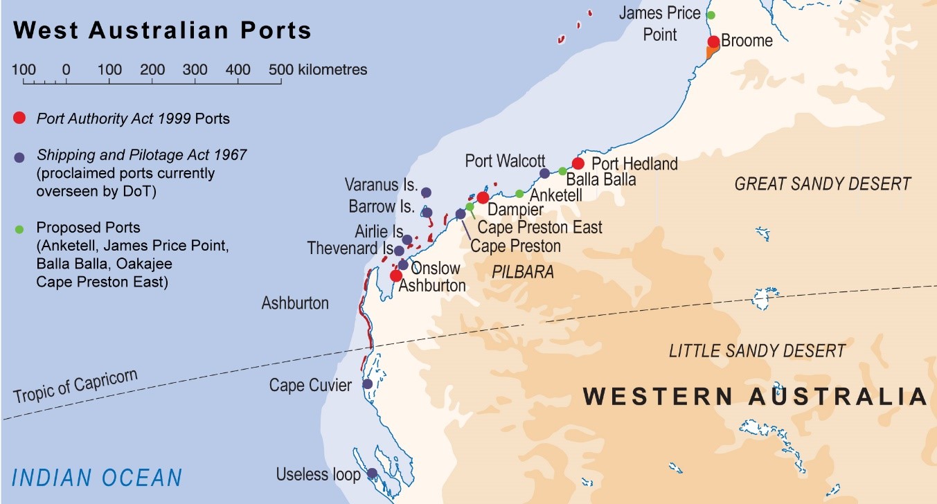
The main focus area for the DSN was the Pilbara in WA’s tropical North West, a region with some of the largest recent proposed dredging projects and with the greatest levels of uncertainty in terms of contemporary understanding of biodiversity distribution and environmental resilience to the pressures associated with this.

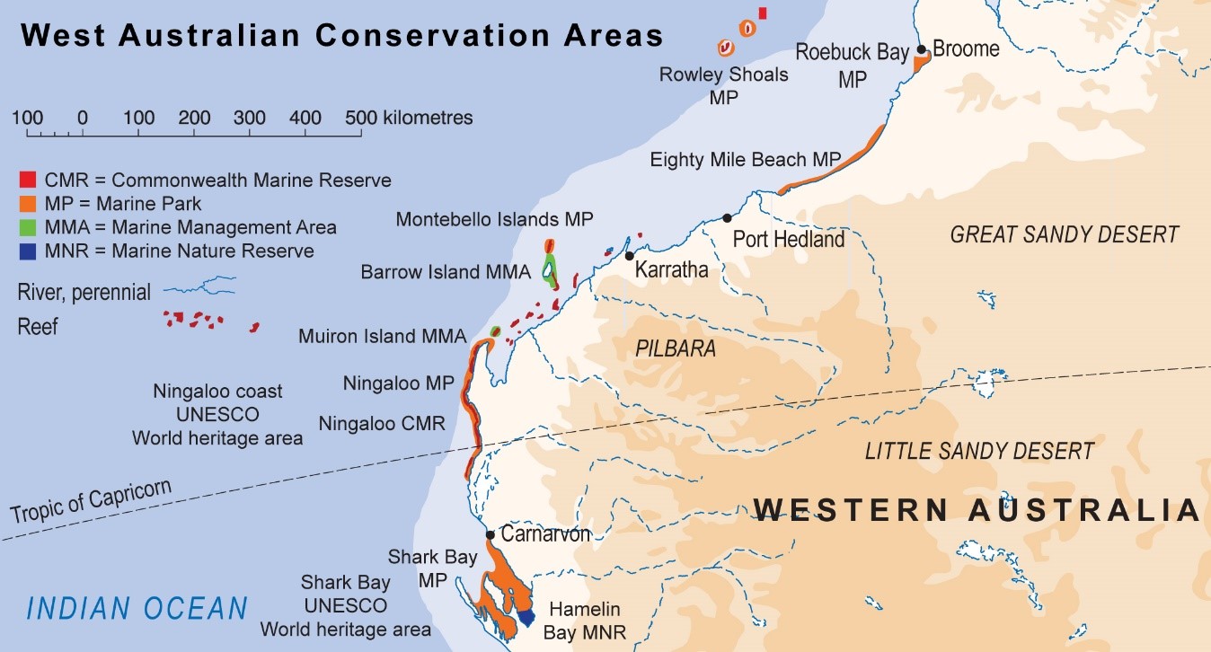
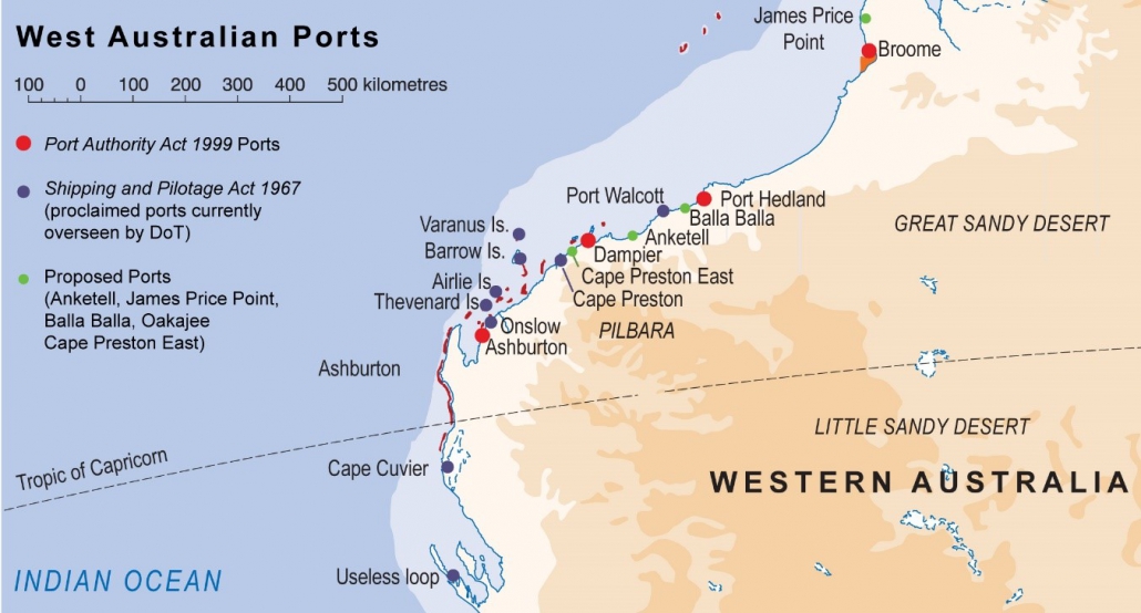
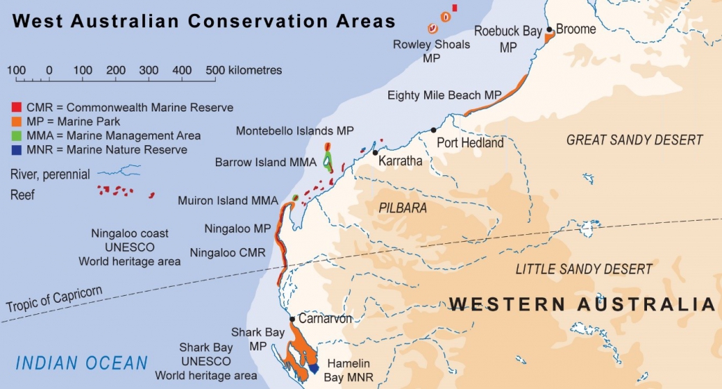
Since 2000, there has been 27 dredging projects in the Pilbara region, with a combined total dredging volume of 250 million m3 of sediment all carried out in a region boasting exceptional marine biodiversity, featuring some of the least disturbed pristine waters in the world (including the World Heritage Areas of Shark Bay, Ningaloo Reef and the Kimberley National Heritage Area).


Maps of northwestern Australia, showing existing and proposed ports and significant conservation areas


Recognising the critical importance of the potential environmental consequences of dredging in WA and the urgent need for it to be addressed, in 2013 WAMSI established the Dredging Science Node.

Eighty-one scientists from 10 collaborating research organisations were supported by $9.5 million invested by Woodside, Chevron and BHP as environmental offsets, with a further $9.5 million co-invested by the WAMSI Joint Venture partners.

The research program worked across nine integrated research themes to address key areas of uncertainty around the impacts of large-scale dredging.

“What struck me most before the start of the Dredging Science Node was just how much information there was in the scientific literature on how sediments released into the water column from dredging was a ‘hazard’, and just how little of that information could be used by dredging proponents and regulators to actually assess the risk,”  WAMSI Dredging Science Node Leader (Science) Dr Ross Jones, from the Australian Institute of Marine Science (AIMS) said.

WAMSI CEO Dr Luke Twomey said the strategic objective of the DSN was to improve the capacity within the government and private sector to predict and manage the environmental impacts of dredging in tropical regions of Western Australia, with the outcomes to support the Environmental Protection Authority’s Technical Guidance for the Environmental Impact Assessment Marine Dredging Proposals.

“The more than 55 scientific publications currently produced by the Node (so far) is an extraordinary achievement for the investment, and will go a long way towards much more informed debate and decision making on how best to predict and manage the potential impacts,” Dr Twomey said.

The winner of the Golden Gecko Award will be announced at the department’s Resources Sector Awards for Excellence on August 22, 2019, with the Community Partnership Resources Sector Award.

Link to Minister’s Media Statement

Category:

Dredging Science

WAMSI Dredging Science Shortlisted for Environmental Excellence Award

The Western Australian Marine Science Institution’s Dredging Science Node has been shortlisted for WA’s Environmental Excellence awards.

The WAMSI Dredging Science Node (DSN) is among four projects identified by the Department of Mines, Industry Regulation and Safety’s 2019 Golden Gecko Award for Environmental Excellence which recognises outstanding contributions to innovation and environmental outcomes in the resources sector.

The main focus area for the DSN was the Pilbara in WA’s tropical North West, a region with some of the largest recent proposed dredging projects and with the greatest levels of uncertainty in terms of contemporary understanding of biodiversity distribution and environmental resilience to the pressures associated with this.

Since 2000, there has been 27 dredging projects in the Pilbara region, with a combined total dredging volume of 250 million m3 of sediment all carried out in a region boasting exceptional marine biodiversity, featuring some of the least disturbed pristine waters in the world (including the World Heritage Areas of Shark Bay, Ningaloo Reef and the Kimberley National Heritage Area).


Maps of northwestern Australia, showing existing and proposed ports and significant conservation areas.

Recognising the critical importance of the potential environmental consequences of dredging in WA and the urgent need for it to be addressed, in 2013 WAMSI established the Dredging Science Node.

Eighty-one scientists from 10 collaborating research organisations were supported by $9.5 million invested by Woodside, Chevron and BHP as environmental offsets, with a further $9.5 million co-invested by the WAMSI Joint Venture partners.

The research program worked across nine integrated research themes to address key areas of uncertainty around the impacts of large-scale dredging.

“What struck me most before the start of the Dredging Science Node was just how much information there was in the scientific literature on how sediments released into the water column from dredging was a ‘hazard’, and just how little of that information could be used by dredging proponents and regulators to actually assess the risk,”  WAMSI Dredging Science Node Leader (Science) Dr Ross Jones, from the Australian Institute of Marine Science (AIMS) said.

WAMSI CEO Dr Luke Twomey said the strategic objective of the DSN was to improve the capacity within the government and private sector to predict and manage the environmental impacts of dredging in tropical regions of Western Australia, with the outcomes to support the Environmental Protection Authority’s Technical Guidance for the Environmental Impact Assessment Marine Dredging Proposals.

“The more than 55 scientific publications currently produced by the Node (so far) is an extraordinary achievement for the investment, and will go a long way towards much more informed debate and decision making on how best to predict and manage the potential impacts,” Dr Twomey said.

The winner of the Golden Gecko Award will be announced at the department’s Resources Sector Awards for Excellence on August 22, 2019, with the Community Partnership Resources Sector Award.

Link to Minister’s Media Statement

Drifters and Floaters – One Ten East log

One Ten East Logs from the IIOE-2 voyage aboard RV Investigator will be posted on the WAMSI website during the month long voyage.

Log from One Ten East

The RV Investigator is currently undertaking oceanographic research along the 110°E meridian off Western Australia as part of the second International Indian Ocean Expedition. The voyage is led by Professor Lynnath Beckley of Murdoch University and the research is supported by a grant of sea time on RV Investigator from the CSIRO Marine National Facility.

Date: June 10, 2019 Time:  1200 AWST
Latitude: 22°S Longitude: 112°E
Wind direction: SW Wind speed: 14 knots
Swell direction: SW 4-5 m Depth: 4946 m
Air temperature: 22°C Sea temperature: 25°C
Notes: Currently planning to tow the Triaxus for section 3, in a beautiful rolling swell.


Drifters and Floaters

By Joel Cabrié and Prof Lynnath Beckley

During voyage IN2019_V03 we have deployed 14 weather buoys in the south-east Indian Ocean for the Australian Bureau of Meteorology and the American National Oceanic and Atmospheric Administration.

Meteorological drifting buoys are autonomous platforms that are typically deployed from ships to collect and report basic meteorological measurements. These platforms, as the name implies, drift with the near-surface currents to help fill otherwise data-sparse areas. The style of drifting buoy that is deployed by most meteorological and oceanographic agencies is a spherical buoy (SVP) fitted with a holey-sock drogue that forces the buoy to follow the path of currents near the surface, from which an estimate of the Lagrangian current can be deduced. The Bureau of Meteorology use an SVP-B buoy which measures atmospheric pressure in addition to sea surface temperature and Lagrangian current. A SVP-B buoy is distinguishable from an SVP buoy by a small stub mast on top of the buoy that houses the pressure port.

The main deployment areas for the Bureau of Meteorology are the Indian and Southern Oceans to maximise the benefit to the Bureau’s operations, whilst the Tasman Sea benefits from buoys deployed by MetService, New Zealand. The Bureau currently maintains a fleet of between 25-30 buoys in the Indian and Southern Oceans as part of their contribution to the international drifting buoy program of around 1,450 buoys.


Prior to deployment, on the aft deck of RV Investigator, Dr Jessica Benthuysen (AIMS) holds the drogue, while Maxime Marin (PhD student University of Tasmania) holds the floating buoy of this drifter. Photo: Micheline Jenner AM.

On our 110° East voyage we have also deployed an ARGO float for Australia’s Integrated Marine Observing System (IMOS). These robotic floats have revolutionized oceanography as they are capable of autonomously measuring the temperature and salinity profile in the ocean down to 2,000 m and transmitting this information back to base by satellite each time the float returns to the surface. There is a large international fleet of nearly 4,000 floats operating globally in all oceans providing vital information to oceanographers who monitor and model our blue planet. http://imos.org.au/facilities/argo/.


This schematic diagram shows the passage of an ARGO float as it progresses through its 10-day data collection cycle. Source: IMOS.

During our voyage we have also assisted our Japanese colleagues at the JAMSTEC agency in Tokyo by deploying two APEX deep ARGO floats for them. Remarkably, these round glass floats can monitor the deep ocean down to 6,000 m. However, just getting them to the RV Investigator was a complicated process as they had to be air-freighted from Tokyo to Sydney and then they crossed the Nullarbor on the back of a truck, making it to the Port of Fremantle just in time to be loaded on the RV Investigator! The first results from these floats are available at www.jamstec.go.jp/ARGO/argo_web/argo/?page_id=31&lang=en.

Celebrating World Oceans Day in the Indian Ocean – One Ten East log

One Ten East Logs from the IIOE-2 voyage aboard RV Investigator will be posted on the WAMSI website during the month long voyage.


Log from One Ten East

The RV Investigator is currently undertaking oceanographic research along the 110°E meridian off Western Australia as part of the second International Indian Ocean Expedition. The voyage is led by Professor Lynnath Beckley of Murdoch University and the research is supported by a grant of sea time on RV Investigator from the CSIRO Marine National Facility.


Date: June 09, 2019

Time:  1200 AWST

Latitude: 19°S

Longitude: 111°E

Wind direction: S    

Wind speed: 24 knots

Swell direction: SW 2-3 m

Depth: 2278 m

Air temperature: 23°C

Sea temperature: 26°C

Notes: We are doing the second Trixaus section as we travel towards the North West Cape of Australia.


Celebrating World Oceans Day in the Indian Ocean

By Dr Jessica Benthuysen and Micheline Jenner AM


June 8th is World Oceans Day. First celebrated in 1992, World Oceans Day was officially recognized by the United Nations in 2008. Globally it is important to celebrate the vital role the oceans play, particularly in the light of current threats. Without oceans, life would not exist on our blue planet.

On RV Investigator, an international team of marine scientists comprising equal numbers of male and females is working day and night to understand the dynamics of the south-east Indian Ocean. This voyage is Australia’s contribution to the second International Indian Ocean Expedition (IIOE-2). The expedition is co-sponsored by the UNESCO Intergovernmental Oceanographic Commission (IOC), Scientific Committee on Oceanic Research (SCOR) and the Indian Ocean regional alliance of the Global Ocean Observing System (IOGOOS).

Over the past 26 days we have been at sea repeating a line of oceanographic stations along the 110° East meridian across 30 degrees of latitude, that was last examined by HMAS Diamantina in 1963 during the first IIOE. We have measured chemical and physical properties and collected water samples down to 5,800m depth, which we will compare to data collected during the first expedition. Across every data stream, we have used the latest technologies to investigate organisms from microbes to mesopelagic fishes and megafauna, such as pygmy blue and humpback whales. In addition, we have also focused on bio-optics to ground-truth satellite observations of ocean colour in this oligotrophic part of the blue planet.

We are now en route towards North West Cape adjacent to Ningaloo Reef, a UNESCO World Heritage Site. We are towing a Triaxus, which is an undulating platform with an array of instrumentation to investigate the Eastern Gyral Current, which feeds into the Leeuwin Current.

We celebrated World Oceans Day in anticipation of our team’s dedicated efforts over the last month making a lasting contribution to the understanding of the dynamics of this relatively small, but vitally important ocean, upon which more than a billion people depend.

After celebrating World Oceans Day with a sumptuous lunch in the marine-themed decorated Mess aboard RV Investigator, dessert comprised a beautiful and delicious sponge cake, decorated with a variety of marine biota. Photo: Micheline Jenner AM.


Cutting the World Oceans Day cake revealed the layers of the sea! The three coloured layers showed the optically clear shallow blue waters, the green, subsurface deep chlorophyll maximum zone and then the deep, dark waters of the chocolate layer, complete with flashes of bioluminescence from cake decorating silver balls! Coincidently, the green and blue are also the colours of the RV Investigator! Photo: Micheline Jenner AM.


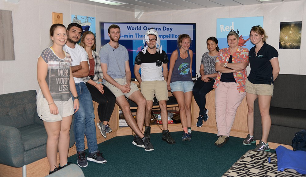
After lunch, most of the students on board, who are assisting the Principal Investigators on this voyage, participated in a World Oceans Day “3-Min Thesis Competition”. From left to right, Aimee van der Reis, Maxime Marin, Camille Grimaldi, Daniel Cohen, Earl Duran, Cora Horstmann, Pramita Ranjit, Peta Vine and Danielle Hodgkinson. Photo: Micheline Jenner AM.


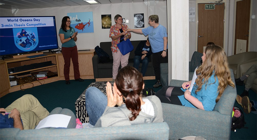
And the winner of the World Oceans Day “3-min Thesis Competition” is… Peta Vine (PhD student from University of Technology Sydney). Here Prof Lynnath Beckley, at right presents Peta with a unique, thimble-sized, shrunken styrofoam cup that has been down to 5000 m on the CTD. At left, is Dr Jessica Benthuysen (AIMS), who expertly organised and staged the competition for the students. Photo: Micheline Jenner AM.


Be sure to follow the daily posts of our Log from One Ten East at https://iioe-2.incois.gov.in and www.wamsi.org.au

Celebrating World Oceans Day in the Indian Ocean – One Ten East log

One Ten East Logs from the IIOE-2 voyage aboard RV Investigator will be posted on the WAMSI website during the month long voyage.

Log from One Ten East

The RV Investigator is currently undertaking oceanographic research along the 110°E meridian off Western Australia as part of the second International Indian Ocean Expedition. The voyage is led by Professor Lynnath Beckley of Murdoch University and the research is supported by a grant of sea time on RV Investigator from the CSIRO Marine National Facility.

Date: June 09, 2019 Time:  1200 AWST
Latitude: 19°S Longitude: 111°E
Wind direction: S Wind speed: 24 knots
Swell direction: SW 2-3 m Depth: 2278 m
Air temperature: 23°C Sea temperature: 26°C
Notes: We are doing the second Trixaus section as we travel towards the North West Cape of Australia.


Celebrating World Oceans Day in the Indian Ocean

By Dr Jessica Benthuysen and Micheline Jenner AM

June 8th is World Oceans Day. First celebrated in 1992, World Oceans Day was officially recognized by the United Nations in 2008. Globally it is important to celebrate the vital role the oceans play, particularly in the light of current threats. Without oceans, life would not exist on our blue planet.

On RV Investigator, an international team of marine scientists comprising equal numbers of male and females is working day and night to understand the dynamics of the south-east Indian Ocean. This voyage is Australia’s contribution to the second International Indian Ocean Expedition (IIOE-2). The expedition is co-sponsored by the UNESCO Intergovernmental Oceanographic Commission (IOC), Scientific Committee on Oceanic Research (SCOR) and the Indian Ocean regional alliance of the Global Ocean Observing System (IOGOOS).

Over the past 26 days we have been at sea repeating a line of oceanographic stations along the 110° East meridian across 30 degrees of latitude, that was last examined by HMAS Diamantina in 1963 during the first IIOE. We have measured chemical and physical properties and collected water samples down to 5,800m depth, which we will compare to data collected during the first expedition. Across every data stream, we have used the latest technologies to investigate organisms from microbes to mesopelagic fishes and megafauna, such as pygmy blue and humpback whales. In addition, we have also focused on bio-optics to ground-truth satellite observations of ocean colour in this oligotrophic part of the blue planet.

We are now en route towards North West Cape adjacent to Ningaloo Reef, a UNESCO World Heritage Site. We are towing a Triaxus, which is an undulating platform with an array of instrumentation to investigate the Eastern Gyral Current, which feeds into the Leeuwin Current.

We celebrated World Oceans Day in anticipation of our team’s dedicated efforts over the last month making a lasting contribution to the understanding of the dynamics of this relatively small, but vitally important ocean, upon which more than a billion people depend.