New report reveals extent of unique marine ecosystem in the Kimberley

A new report into Australia’s remote Kimberley region could hold the key to answering global questions about how some ecosystems survive under extreme environmental conditions.

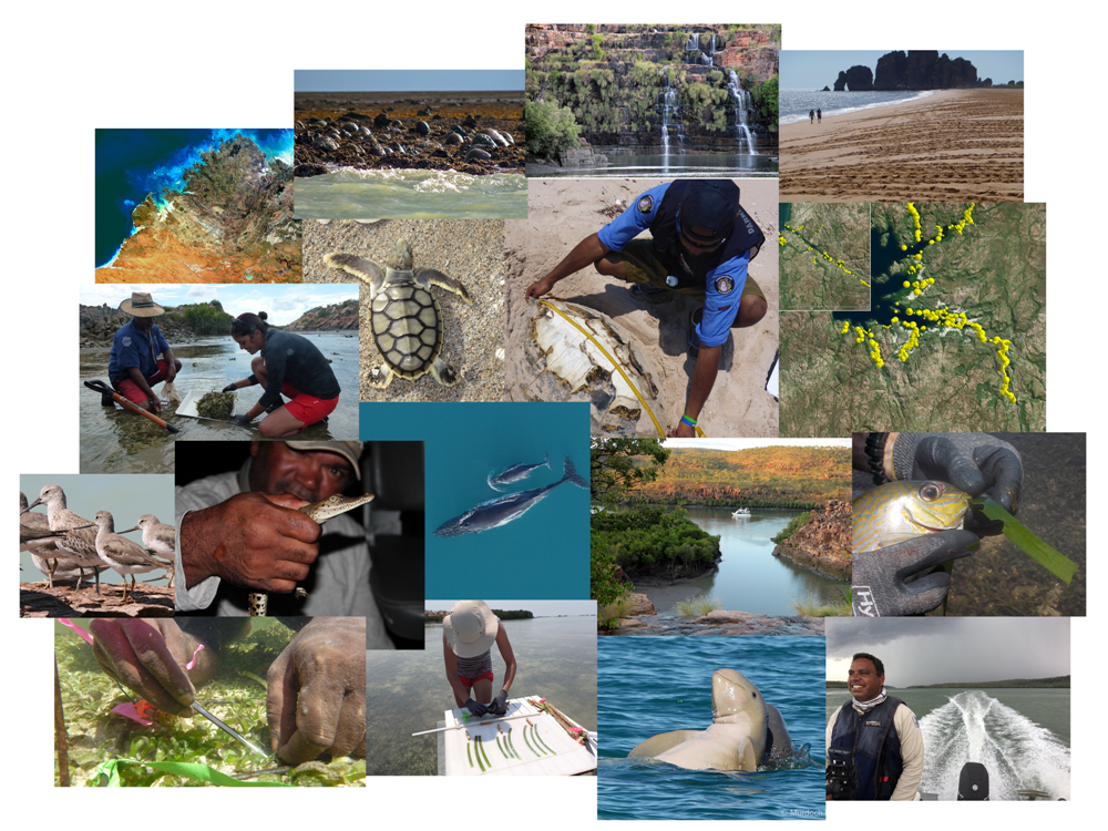
The report, “Strategic Integrated Marine Science for the Kimberley Region”, released today by the Minister for Science Hon. Dave Kelly MLA, is the culmination of five years of research by 200 scientists from 25 organisations working on 23 projects to understand the marine biodiversity and ecology at regional and local scales.

The information has been produced for the Department of Biodiversity, Conservation and Attractions (DBCA) to support decision making and operational activities for the region and the Greater Kimberly Marine Park network managed by DBCA jointly with Traditional Owners. 


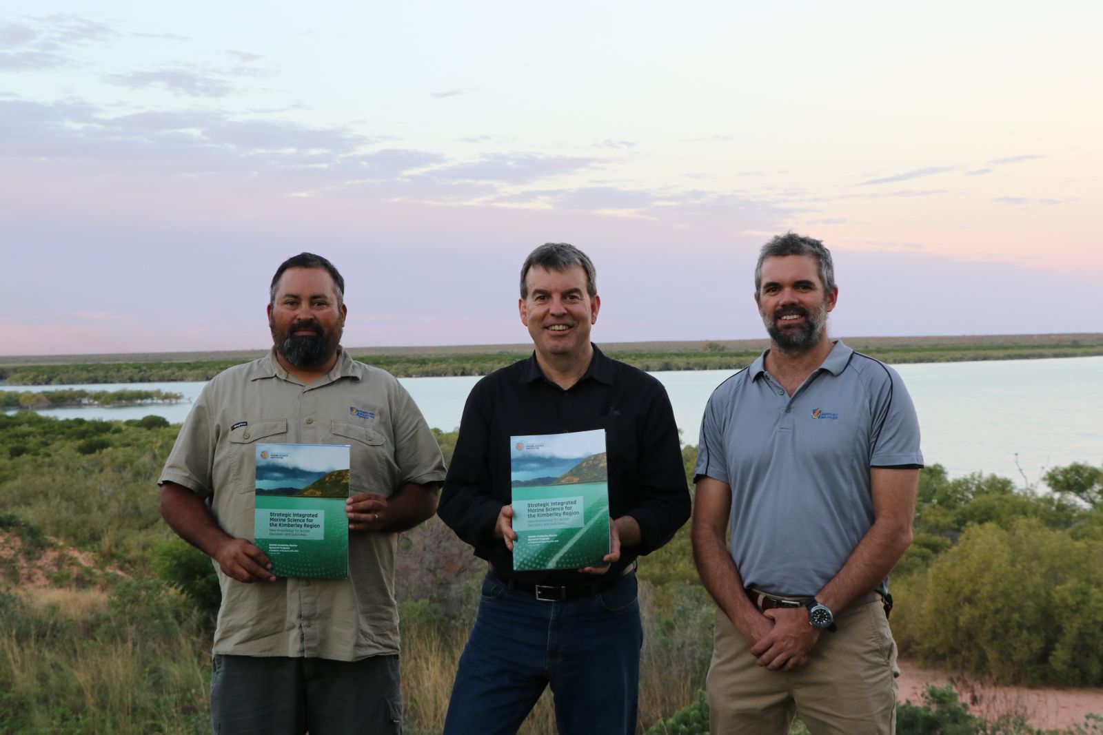
ABOVE: (L-R) Yawuru marine ranger Anthony Richardson, Minister for Science Hon. Dave Kelly MLA and DBCA Marine Park Coordinator Chris Nutt release the WAMSI Kimberley Marine Research Program Report in Broome


The program, managed by the Western Australian Marine Science Institution (WAMSI) collaboration of scientists from state, federal, industry and academic institutions, is one of the most comprehensive assessments of Australia’s North West.

WAMSI Science Program Leader Dr Kelly Waples (DBCA) said the report provides valuable information that can be used to predict and manage the likely changes in the future. 

“How the Kimberley environment changes over time will be determined by the interaction of economic, ecological and social processes, climate change, human population dynamics and industry,” Dr Waples said. “By understanding how the environment has changed and the ecosystem has adapted over the past 100 years to what it is today, we can better predict the likely response to current and future pressures and how we might mitigate any impacts.” 

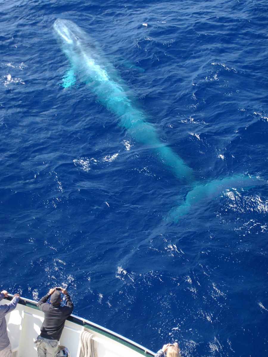
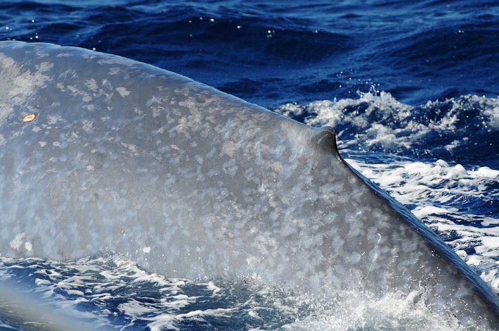
This physically complex inshore environment supports a diverse range of habitats that include seagrasses and coral reefs, extensive intertidal mudflats and sponge-dominated filter-feeding communities with high levels of biological diversity. The region also supports large and iconic marine fauna including whales, dolphins, dugongs, turtles and estuarine crocodiles.

While aboriginal people have lived in the Kimberley for millennia and retain strong cultural connections to their saltwater country, this coastal and marine environment increasingly supports other activities such as tourism, commercial and recreational fishing, pearling, aquaculture and major port facilities associated with resource industries.

Despite the growth in activity, the research found that anthropogenic impacts remain low compared with other parts of the Western Australian coast and disturbance to much of the Kimberley marine environment is considered to be minor.

However, the study highlights the region is likely to be increasingly affected by a number of pressures including: climate change-related impacts such as coral bleaching; regional development and growth; and increased human access and use.

The $30 million Kimberley Marine Research Program was funded through major investment supported by $12 million from the Western Australian government co-invested by the WAMSI partners and supported by the Traditional Owners of the Kimberley.

Link to Minister for Science Hon. Dave Kelly MLA media statement


Category: 

Kimberley Marine Research Program

Bio-optics and Ocean Colour – One Ten East Log

One Ten East Logs from the IIOE-2 voyage aboard RV Investigator will be posted on the WAMSI website during the month long voyage.

It’s getting warmer and we are loving it! – Captain Micheline Jenner

Log from One Ten East

The RV Investigator is currently undertaking oceanographic research along the 110°E meridian off Western Australia as part of the second International Indian Ocean Expedition. The voyage is led by Professor Lynnath Beckley of Murdoch University and the research is supported by a grant of sea time on RV Investigator from the CSIRO Marine National Facility.

Date: May 30, 2019 Time:  1200 AWST
Latitude: 20°S Longitude: 110°E
Wind direction: E Wind speed: 5 knots
Swell direction: SW 1 m Depth: 4133 m
Air temperature: 26°C Sea temperature: 27°C

Notes: A minke whale swam by the vessel today to confirm our sonobuoy detections! Another nice sunny day for the optics team!

Bio-optics & Ocean Colour

By Prof David Antoine

Studies of marine bio-optics are being conducted from the RV Investigator during the 110East voyage.

Marine bio-optics is the scientific study of interactions between electromagnetic radiation (near ultraviolet to the visible and the near infrared) and particles or dissolved substances of biological origin in the water.

The interaction is described through absorption and scattering, which are referred to as inherent optical properties (IOPs).

These properties only depend on the composition of the medium, and not on the way it is illuminated (e.g. sun light on a clear day versus a cloudy day etc.).

By measuring these IOPs and the quantities that determine them (e.g., particle sizes, particle composition and pigments), one can derive bio-optical algorithms.

From the ship we will make in-situ measurements of the IOPs using a range of instruments as well as measuring particle sizes and composition.

Dr Matthew Slivkoff (In situ Marine Optics) and Dr Wojciech Klonowski (In situ Marine Optics) indictating the components of their IOP (Inherent Optical Properties) package which they have just retrieved after collecting measurements in the south-east Indian Ocean. Photo: Micheline Jenner AM.

Satellite ocean colour radiometry is the technique by which we quantify phytoplankton biomass from space.

Proxies of this biomass, such as chlorophyll concentrations can be derived from the satellite observations of the ocean.

The launch in 1978 of the first satellite carrying an ocean colour sensor, revolutionized the way oceanographers saw phytoplankton dynamics in the ocean.

The obvious advantage of this satellite technique is the provision of uninterrupted data sets over the world’s oceans which can be used in a wide range of science studies and applications.

Prof David Antoine (Curtin University) holds a C-OPS profiling radiometer prior to deployment to measure the underwater light profile along the 110°East meridian. Photo: Micheline Jenner AM

Charles Kovach (NOAA, USA) prepares to deploy a HyperPRO in-water profiling radiometer for establishing the underwater light profile in the tropical south-east Indian Ocean. Photo: Micheline Jenner AM.

Be sure to follow the daily posts of our Log from One Ten East at https://iioe-2.incois.gov.in and www.wamsi.org.au

Dilution Experiments – One Ten East Log

One Ten East Logs from the IIOE-2 voyage aboard RV Investigator will be posted on the WAMSI website during the month long voyage.

Another wonderful day had aboard RV Investigator with stunning calm conditions across the day and an amazing sunset.
– Captain Micheline Jenner

Log from One Ten East

The RV Investigator is currently undertaking oceanographic research along the 110°E meridian off Western Australia as part of the second International Indian Ocean Expedition. The voyage is led by Professor Lynnath Beckley of Murdoch University and the research is supported by a grant of sea time on RV Investigator from the CSIRO Marine National Facility.

Date: May 29, 2019 Time:  1200 AWST
Latitude: 21.5°S Longitude: 110°E
Wind direction: SE Wind speed: 10 knots
Swell direction: S 1 m Depth: 5070 m
Air temperature: 25°C Sea temperature: 25°C

Notes: Beautiful sunny weather, warm seas and lots of tropical flying fish.

Dilution Experiments

By Michael Landry

Phytoplankton can go through one or two generations (cell divisions) per day and are often eaten almost as fast as they divide, by protozoan grazers.

Because the size ranges of phytoplankton and microzooplankton broadly overlap, they cannot be mechanically separated from one another to determine these two different rates.

We do, however, have a technique for this, which involves dilution of the grazing impact. This entails changing the encounter frequency of predators and prey using filtered water with the same chemistry, from the same depth.

We create two conditions­–one with natural concentrations of predators and prey and the other in which the grazing has been slowed by about 2/3rds. From the differences in the measured rates of increase of phytoplankton of the two treatments, we can solve the equations for the two unknown rates.

We run our experiments in a seawater-cooled, shipboard incubator system that has 6 light levels simulating the conditions of underwater light at the six depths where we collected our samples from the CTD.

The change in phytoplankton concentration in each bottle is measured by chlorophyll and by flow cytometry analyses of dominant populations.

After a lot of filtering, analyses and calculations, we will have a pretty good idea of how much of phytoplankton productivity is consumed by microzooplankton each day, how that varies with depth in the euphotic zone, and if there are significant differences among the stations or regions that we are sampling along the 110°East line.

Prof Michael Landry (Scripps Institution of Oceanography, USA) and Prof Raleigh Hood (University of Maryland Center for Environmental Science) filtering water from the CTD in preparation for Prof Landry’s world-renowned dilution experiments, which are conducted on the aft deck of RV Investigator. Photo: Micheline Jenner AM.


Simulating different light levels experienced at six different depths in the ocean, these seawater-cooled incubation tanks allow the calculation of phytoplankton growth and microzooplankton grazing rates. Photo: Micheline Jenner AM.


Each incubation box contains two bottles, one with the natural conditions of predators and prey and the other where the grazing conditions have been reduced or diluted. Photo: Micheline Jenner AM.


Prof Raleigh Hood (University of Maryland Center for Environmental Science) and Claire Davies (IMOS/CSIRO) tending to the dilution experiments on the aft deck of the RV Investigator. Here they are removing the bottles that have incubated for 24 hours. Photo: Micheline Jenner AM.

Be sure to follow the daily posts of our One Ten East Logs from the IN2019_V03 aboard RV Investigator at https://iioe-2.incois.gov.in and www.wamsi.org.au .

Modeling the Indian Ocean Pelagic Ecosystem – One Ten East Log

One Ten East Logs from the IIOE-2 voyage aboard RV Investigator will be posted on the WAMSI website during the month long voyage.


Log from One Ten East

The RV Investigator is currently undertaking oceanographic research along the 110°E meridian off Western Australia as part of the second International Indian Ocean Expedition. The voyage is led by Professor Lynnath Beckley of Murdoch University and the research is supported by a grant of sea time on RV Investigator from the CSIRO Marine National Facility.

Date: May 28, 2019

Time:  1200 AWST

Latitude: 23°S

Longitude: 110°E

Wind direction: ESE           

Wind speed: 6 knots

Swell direction: S 1.5 m

Depth: 5052 m

Air temperature: 24°C

Sea temperature: 25°C

Notes: It’s Station 12 today! We have passed the Tropic of Capricorn. Welcome to the Tropics!  


Modeling the Indian Ocean Pelagic Ecosystem

By Prof Raleigh Hood

This voyage (IN2019_V03) on the RV Investigator will traverse and sample one of the most poorly understood regions of the world’s oceans along110°East in the south-east Indian Ocean. An important goal of this IIOE-2 voyage is to characterise the physical, chemical and biological properties of the waters and determine how they change from the temperate waters at the southern most stations to the northern most stations in the tropics. In particular, how do the species composition and biomass of microscopic planktonic organisms vary along this 110°East meridian transect and how do ocean currents, nutrient concentrations and the availability of light in the ocean drive this variability?


Aboard RV Investigator, Prof Raleigh Hood aims to use many of the variables collected along the 110°East meridian to develop biogeochemical models of the south-east Indian Ocean. Photo: Micheline Jenner AM.


Prof Raleigh Hood (University of Maryland Center for Environmental Science), lead author of the second International Indian Ocean Expedition Science Plan explains the content to Aimee van de Reis (PhD student University of Auckland), at left and Danielle Hodgkinson (Murdoch University) at right. The Science Plan has six research themes and the voyage along 110°East is contributing to several of these. Photo: Micheline Jenner AM.


Characterising these patterns is important for developing computer models that simulate the circulation and biogeochemistry of the Indian Ocean. They also serve to effectively test if existing models are correct. Once we have established that our models can simulate the present day Indian Ocean, we can use them to ascertain how much it might change in the future, as a result of the impacts of humans. We know that increasing atmospheric carbon dioxide concentrations and global warming are having significant effects in the Indian Ocean, including higher water temperatures, more dissolved carbon dioxide and lowering of pH (ocean acidification). Our validated models will allow us to predict how these properties might change in fifty years, or even a century into the future, and how these alterations might impact the Indian Ocean food web.


An example of an existing oceanographic model for the Indian Ocean that shows the sea surface temperature of the ocean during February. Source: NOAA.


Be sure to follow the daily posts of our One Ten East Logs from the IN2019_V03 aboard RV Investigator at https://iioe-2.incois.gov.in and www.wamsi.org.au .

Modeling the Indian Ocean Pelagic Ecosystem – One Ten East Log

One Ten East Logs from the IIOE-2 voyage aboard RV Investigator will be posted on the WAMSI website during the month long voyage.

Log from One Ten East

The RV Investigator is currently undertaking oceanographic research along the 110°E meridian off Western Australia as part of the second International Indian Ocean Expedition. The voyage is led by Professor Lynnath Beckley of Murdoch University and the research is supported by a grant of sea time on RV Investigator from the CSIRO Marine National Facility.

Date: May 28, 2019 Time:  1200 AWST
Latitude: 23°S Longitude: 110°E
Wind direction: ESE Wind speed: 6 knots
Swell direction: S 1.5 m Depth: 5052 m
Air temperature: 24°C Sea temperature: 25°C

Notes: It’s Station 12 today! We have passed the Tropic of Capricorn. Welcome to the Tropics!

Modeling the Indian Ocean Pelagic Ecosystem

By Prof Raleigh Hood

This voyage (IN2019_V03) on the RV Investigator will traverse and sample one of the most poorly understood regions of the world’s oceans along110°East in the south-east Indian Ocean. An important goal of this IIOE-2 voyage is to characterise the physical, chemical and biological properties of the waters and determine how they change from the temperate waters at the southern most stations to the northern most stations in the tropics. In particular, how do the species composition and biomass of microscopic planktonic organisms vary along this 110°East meridian transect and how do ocean currents, nutrient concentrations and the availability of light in the ocean drive this variability?

Aboard RV Investigator, Prof Raleigh Hood aims to use many of the variables collected along the 110°East meridian to develop biogeochemical models of the south-east Indian Ocean. Photo: Micheline Jenner AM.


Prof Raleigh Hood (University of Maryland Center for Environmental Science), lead author of the second International Indian Ocean Expedition Science Plan explains the content to Aimee van de Reis (PhD student University of Auckland), at left and Danielle Hodgkinson (Murdoch University) at right. The Science Plan has six research themes and the voyage along 110°East is contributing to several of these. Photo: Micheline Jenner AM.

Characterising these patterns is important for developing computer models that simulate the circulation and biogeochemistry of the Indian Ocean. They also serve to effectively test if existing models are correct. Once we have established that our models can simulate the present day Indian Ocean, we can use them to ascertain how much it might change in the future, as a result of the impacts of humans. We know that increasing atmospheric carbon dioxide concentrations and global warming are having significant effects in the Indian Ocean, including higher water temperatures, more dissolved carbon dioxide and lowering of pH (ocean acidification). Our validated models will allow us to predict how these properties might change in fifty years, or even a century into the future, and how these alterations might impact the Indian Ocean food web.

An example of an existing oceanographic model for the Indian Ocean that shows the sea surface temperature of the ocean during February. Source: NOAA.

Be sure to follow the daily posts of our One Ten East Logs from the IN2019_V03 aboard RV Investigator at https://iioe-2.incois.gov.in and www.wamsi.org.au .

Tracking Sulphur Cycling Microbes in the Indian Ocean – One Ten East Log

One Ten East Logs from the IIOE-2 voyage aboard RV Investigator will be posted on the WAMSI website during the month long voyage.

Log from One Ten East

The RV Investigator is currently undertaking oceanographic research along the 110°E meridian off Western Australia as part of the second International Indian Ocean Expedition. The voyage is led by Professor Lynnath Beckley of Murdoch University and the research is supported by a grant of sea time on RV Investigator from the CSIRO Marine National Facility.

Date: May 27, 2019 Time:  1200 AWST
Latitude: 24.5°S Longitude: 110°E
Wind direction: SSW Wind speed: 9 knots
Swell direction: SW 2 m Depth: 4167 m
Air temperature: 23.5°C Sea temperature: 24.2°C

Notes: Today it is sunny with the wind abating and this is making the optics group very happy!

Tracking Sulphur Cycling Microbes in the Indian Ocean

By Justin Seymour

Although inconspicuous, microbes are the most abundant and diverse organisms in the ocean. Microbes form the base of the marine food web, while their metabolic activities control the chemical transformations that regulate ocean nutrient cycles and global climate.

Among these important chemical cycles is the ocean’s sulphur cycle, which is governed by several important groups of marine microbes. Sulphur is an essential element for all living organisms, while some sulphur compounds are also key components within the chemical cycles that control climatic processes. Specifically, a compound called DMSP (dimethyl sulphoniopropionate) is produced by several species of phytoplankton, which use it for various metabolic functions. DMSP is also an essential resource for marine bacteria, which obtain a significant proportion of their carbon and sulphur requirements from this compound. However, not all bacteria use DMSP in the same way, and this can have a big impact on the chemical cycling processes that influence our climate.

While some bacteria use the sulphur in DMSP to support their growth, others convert the DMSP into another important sulphur molecule called DMS (dimethylsulphide). The relative importance of these two bacterial pathways is significant, because DMS is a gas that is emitted from the ocean into the atmosphere, where it is converted into cloud condensation nuclei, which influence regional climate.

James O’Brien (PhD student University of Technology Sydney) filtering seawater samples for sulphur microbes. Photo: Micheline Jenner AM.


Amaranta Forcardi (PhD student Macquarie University) doing the long 12-hour filtration for viruses. Photo: Micheline Jenner AM.

We currently have a very limited understanding of the environmental factors that govern these different microbial-controlled DMSP transformation pathways and how the microbiological characteristics of seawater can ultimately influence climate. Our team, led by James O’Brien and Justin Seymour from the University of Technology Sydney, are using a combination of molecular microbiology and analytical chemistry tools (gas chromatograph) to track the biological drivers of sulphur cycling in the Indian Ocean. The latitudinal extent of this voyage is enabling us to determine how different oceanographic conditions govern these globally important processes.

Be sure to follow the daily posts of our Log from One Ten East at https://iioe-2.incois.gov.in and www.wamsi.org.au

Tracking Sulphur Cycling Microbes in the Indian Ocean – One Ten East Log

One Ten East Logs from the IIOE-2 voyage aboard RV Investigator will be posted on the WAMSI website during the month long voyage.

Log from One Ten East

The RV Investigator is currently undertaking oceanographic research along the 110°E meridian off Western Australia as part of the second International Indian Ocean Expedition. The voyage is led by Professor Lynnath Beckley of Murdoch University and the research is supported by a grant of sea time on RV Investigator from the CSIRO Marine National Facility.


Date: May 27, 2019 Time:  1200 AWST
Latitude: 24.5°S Longitude: 110°E
Wind direction: SSW Wind speed: 9 knots
Swell direction: SW 2 m Depth: 4167 m
Air temperature: 23.5°C Sea temperature: 24.2°C
Notes: Today it is sunny with the wind abating and this is making the optics group very happy!


Tracking Sulphur Cycling Microbes in the Indian Ocean

By Justin Seymour

Although inconspicuous, microbes are the most abundant and diverse organisms in the ocean. Microbes form the base of the marine food web, while their metabolic activities control the chemical transformations that regulate ocean nutrient cycles and global climate.

Among these important chemical cycles is the ocean’s sulphur cycle, which is governed by several important groups of marine microbes. Sulphur is an essential element for all living organisms, while some sulphur compounds are also key components within the chemical cycles that control climatic processes. Specifically, a compound called DMSP (dimethyl sulphoniopropionate) is produced by several species of phytoplankton, which use it for various metabolic functions. DMSP is also an essential resource for marine bacteria, which obtain a significant proportion of their carbon and sulphur requirements from this compound. However, not all bacteria use DMSP in the same way, and this can have a big impact on the chemical cycling processes that influence our climate.

While some bacteria use the sulphur in DMSP to support their growth, others convert the DMSP into another important sulphur molecule called DMS (dimethylsulphide). The relative importance of these two bacterial pathways is significant, because DMS is a gas that is emitted from the ocean into the atmosphere, where it is converted into cloud condensation nuclei, which influence regional climate.


James O’Brien (PhD student University of Technology Sydney) filtering seawater samples for Sulphur microbes. Photo: Micheline Jenner AM.


Amaranta Forcardi (PhD student Macquarie University) doing the long 12-hour filtration for viruses. Photo: Micheline Jenner AM.


We currently have a very limited understanding of the environmental factors that govern these different microbial-controlled DMSP transformation pathways and how the microbiological characteristics of seawater can ultimately influence climate. Our team, led by James O’Brien and Justin Seymour from the University of Technology Sydney, are using a combination of molecular microbiology and analytical chemistry tools (gas chromatograph) to track the biological drivers of sulphur cycling in the Indian Ocean. The latitudinal extent of this voyage is enabling us to determine how different oceanographic conditions govern these globally important processes.

Be sure to follow the daily posts of our Log from One Ten East at https://iioe-2.incois.gov.in and www.wamsi.org.au


Using Gas to Grow – One Ten East Log

One Ten East Logs from the IIOE-2 voyage aboard RV Investigator will be posted on the WAMSI website during the month long voyage.

Log from One Ten East

The RV Investigator is currently undertaking oceanographic research along the 110°E meridian off Western Australia as part of the second International Indian Ocean Expedition. The voyage is led by Professor Lynnath Beckley of Murdoch University and the research is supported by a grant of sea time on RV Investigator from the CSIRO Marine National Facility.


Date: May 26, 2019 Time:  1200 AWST
Latitude: 26°S Longitude: 110°E
Wind direction: SSE Wind speed: 18 knots
Swell direction: SSW Depth: 3988 m
Air temperature: 22.6°C Sea temperature: 23.8°C
Notes: There is a clear influence of the Leeuwin Current on the samples being collected with more tropical species appearing in the plankton nets and the seabirds sighted.

Using Gas to Grow

By Dr Eric Raes

During this voyage we are focusing our research efforts on nitrogen in particular, as this element is essential for all life forms on Earth. On land, we are accustomed to adding nitrogen as a fertiliser to increase the growth and yield of our crops. As on land, in the sea, nitrogen is a vital nutrient for the growth of microscopic organisms. On this voyage, we are examining the different ways nitrogen is used by the microbes and phytoplankton, which supply us with the oxygen that we breathe.

One of our questions is to determine how much energy from the sun is captured by the phytoplankton and how the availability of nitrogen controls their growth. Another question targets a special group of microscopic life, the nitrogen gas fixers! These microorganisms are able to use the nitrogen gas from the atmosphere (which is roughly 80% nitrogen gas and 20% oxygen). Although most organisms use oxygen, only a select few can actually use nitrogen.

In agriculture, we have long known about the beneficial effects of microorganisms that use nitrogen gas such as Rhizobium in the root nodules of peas and beans. In the ocean, however, the beneficial effects of using nitrogen gas as an energy source for growth are less well understood. During our voyage we have set up experiments to measure just how much nitrogen gas the microorganisms are using. The results from these experiments will give us a better understanding how much food (in fact, energy for fishes), is available in the south-east Indian Ocean and what might happen in the future.

Dr Eric Raes (CSIRO) with Cora Horstmann (PhD student at the Alfred Wagener Institute in Germany) tending their experiments in the through-flow seawater incubators on board the RV Investigator. Photo: Micheline Jenner AM


Dr Eric Raes (CSIRO) with Cora Horstmann (PhD student at the Alfred Wagener Institute in Germany) examining their incubated samples for their nitrogen-uptake experiments on board the RV Investigator. Photo: Micheline Jenner AM.


The blue light the modular Isotope Laboratory aboard the RV Investigator, Cora Horstmann (PhD student at the Alfred Wagener Institute in Germany) prepares for nitrogen uptake experiments with Dr Eric Raes (CSIRO). Photo: Micheline Jenner AM.


Be sure to follow our daily Log from One Ten East at https://iioe-2.incois.gov.in or www.wamsi.org.au.


A Hard Day’s Night – One Ten East Log

One Ten East Logs from the IIOE-2 voyage aboard RV Investigator will be posted on the WAMSI website during the month long voyage.

Log from One Ten East

The RV Investigator is currently undertaking oceanographic research along the 110°E meridian off Western Australia as part of the second International Indian Ocean Expedition. The voyage is led by Professor Lynnath Beckley of Murdoch University and the research is supported by a grant of sea time on RV Investigator from the CSIRO Marine National Facility.


Date: May 25, 2019 Time: 1200 AWST
Latitude: 27.5°S Longitude: 110°E
Wind direction: SE Wind speed:  knots
Swell direction: SSW Depth: 5651 m
Air temperature: 21.3°C Sea temperature: 22°C
Notes: All’s well as RV Investigator travels northwards into warmer air and seas, about 200nm west of the Abrolhos Islands.


A Hard Day’s Night

By Prof Lynnath Beckley

(Chief Scientist IN2019_V03)

Aboard the RV Investigator we are approaching the middle stations along our 110°E line and have proceeded from cool, temperate waters to warmer more subtropical waters. Operations are proceeding smoothly – watches swop with 12-hour regularity, equipment gets deployed, samples get taken as per the daily roster and we no longer really know which day of the week it is!

Dr Matt Slivkoff (In-Situ Marine Optics) attentively watches his I-OP (Inherent Optic Properties) package with RV Investigator crewman Dennis Bassi, as the sun sinks over the Indian Ocean. Photo: Micheline Jenner AM.
The ship operates on a 24/7 basis and most of the scientists are on 12-hour shifts, which rotate at 2am and 2pm. The 2am shift has a few hours of steaming until the ship reaches the location of the next station and, as we are approaching it, a sonobuoy is deployed, the Continuous Plankton recorder is retrieved, and by 7am the CTD is descending to the inky depths of the Indian Ocean. This takes several hours as the seafloor is generally deeper than 5,000 m! As the CTD returns to the surface, the Niskin bottles are fired to collect water at the different depths as per the water budget. When the CTD is back on board there is an intense period of emptying of the Niskin bottles so that everyone can get the water they require for samples and experiments.
While the water is dispensed, other scientists start with different activities. Initially, the Indian Ocean Standard Net is deployed so that it can sample zooplankton in the top 200m of the water column. After this, when the sun is hopefully high in the sky, the optics team swings into action deploying a range of equipment to measure the optical qualities of the water column. While this is happening, “lunch” is served – though it is not uncommon to see someone having cereal or Vegemite on toast as that time slot equates to their breakfast!
The 2pm to 2am watch starts with some netting action – the oblique tow for mesoplankton is followed by the 90-minute tow with the EZ net that yields stratified zooplankton samples in upper 500m of the water column. On the steam back to station the micro-zooplankton sampler is deployed and once back on station we use the fine-mesh Heron net for a vertical haul for the small zooplankton that are prey for the many larval fishes that we are catching. Then, the physical oceanographers get back into action and deploy the Vertical Mixing Profiler. And, as the sun sets over the Indian Ocean, it is time for “dinner” though for some it is now lunch!
Evening sampling commences with repeated tows of the surface neuston net to catch plankton that migrates to the surface at night. This entails factory-like activity in the laboratory as the contents of each tow are separated, identified and frozen for food web analyses or preserved for genetics. Then, another oblique mesoplankton haul before we settle in for an evening, shallow CTD (only 500m depth) from which most of the water is used for a series of on board incubation experiments. There is a further night-time vertical Indian Ocean Standard Net haul and then we are into another EZ net deployment with flashes of bioluminescence showing up on the screen as the denizens of the deep streak by. After 90 minutes, the net is back on deck and the samples start to be sorted and identified. Finally, the CPR is deployed out the stern and the RV Investigator is on its way to the next station up the 110°E line. Soon, the 2am watch will appear clutching their mugs of coffee and ready to see what the next station brings…
The neuston net is deployed in the surface waters to catch organisms that migrate to the surface at night to feed, such as rock lobster larvae and lantern fishes. Photo: Micheline Jenner AM.


Even in the dead of night instruments are deployed from RV Investigator. Here an APEX Deep ARGO buoy is being deployed for the Japanese Agency (JAMSTEC) as part of the international collaboration of the IIOE-2. Photo: Karlie McDonald.


Just after the CPR is retrieved and just before the deep CTD cast, in the pre-dawn hues, two sonobuoys are deployed in the water. Here Curt Jenner AM monitors the whale calls on the computer systems. Photo: Micheline Jenner AM


And, yes, it must be near the weekend as the footy tipping competition is in full swing!

Be sure to follow our daily Log from One Ten East at https://iioe-2.incois.gov.in or www.wamsi.org.au


Listening to the Sea – One Ten East Log

One Ten East Logs from the IIOE-2 voyage aboard RV Investigator will be posted on the WAMSI website during the month long voyage.


Log from One Ten East


The RV Investigator is currently undertaking oceanographic research along the 110°E meridian off Western Australia as part of the second International Indian Ocean Expedition. The voyage is led by Professor Lynnath Beckley of Murdoch University and the research is supported by a grant of sea time on RV Investigator from the CSIRO Marine National Facility.


Date: May 24, 2019

Time:  1200 AWST

Latitude: 29°S

Longitude: 110°E

Wind direction: SE  

Wind speed: 17 knots

Swell direction: SW

Depth: 5589 m

Air temperature: 20°C

Sea temperature: 21°C

Notes: As we travel northward along the line we are seeing a steady change from cool-temperate to sub-tropical conditions.


Listening to the Sea
 

By Capt Curt Jenner AM and Capt Micheline Jenner AM
 

For decades open ocean surveys for cetaceans have involved visual observations with field binoculars and identification guides. Using technology from World War 2, a new version of an old tool is currently assisting scientific surveys. Sonobuoys, underwater microphones (hydrophones) developed by the military, are now available for scientific research, such as those provided by the Australian Department of Defence for this project. Initially designed to detect enemy vessels by tracking acoustic “targets”, whale researchers can now track biological targets namely cetaceans (whales and dolphins), simply by listening for their calls. Presence and absence data, leading to abundance estimates, can be collected while transiting ocean basins. Amazingly, the listening strip width of acoustic surveys is 150 nautical miles or 280 km, which is 75 times more effective than the two nautical mile visual survey strip.


Capt Curt Jenner AM monitors a sonobuoy for whale calls using sophisticated software. The information regarding the frequency of the sounds detected and the direction of the whale call, in relation to the sonobuoy, provides valuable insight into the migration paths of pygmy blue whales as they traverse the south-east Indian Ocean towards Indonesia. Photo: Micheline Jenner AM.


Each cetacean species creates unique calls, transmitting sounds on varying frequencies. Travelling the deep water of the south-east Indian Ocean with several daily sonobuoy deployments, the most prevalent acoustic detections by the Jenners so far, have been pygmy blue whale calls. At the first and most southern station, Antarctic blue, minke and fin whales were also recorded.


A pygmy blue whale call is displayed as 5 horizontal lines in bright green at the centre of the computer screen. This colour indicates directionality, and in fact, this whale is located to the northeast of the sonobuoy. Photo: Micheline Jenner AM. 


The IIOE-2 survey is providing new understanding regarding the characteristics of pygmy blue whale migration paths, particularly in concert with the collected oceanographic data. By tracking the direction of all the pygmy blue whale acoustic detections while RV Investigator moves northward along the 110°E line, the pygmy blue whale migration path towards Indonesian calving grounds, can be carefully documented. This is important because the presence or absence of animals such as whales, some of which feed low down on the food chain can lead to a better understanding of the health of the Indian Ocean. Are the blue whales travelling in large herds, individually or in twos and threes? Are they following specific isotherms (temperatures) while searching for productivity hotspots?


From the foremast of RV Whale Song, Curt and Micheline Jenner’s whale research ship, a pygmy blue whale is observed travelling through the Perth Canyon. This deep water canyon is an important feeding area in the south-east Indian Ocean for these pygmy blue whales, which are also seasonal travellers to the tropical waters of Indonesia during the austral winter. Photo: Tasmin Jenner.


Each individual pygmy blue whale has unique blue-grey blotch patterns, some of which are healed scars from cookie-cutter shark bites. Photo: Micheline Jenner AM.


From the decks of RV Investigator, Curt and Micheline Jenner are keen to visually observe some migrating pygmy blue whales. So far the sounds are alluring… but actual sightings of the animals have been elusive. Thirty years of research has taught the whale team to remain hopeful!


Aboard RV Investigator from the 7th level observation deck, ten-minute seabird surveys each hour, during daylight hours are also being conducted by Curt and Micheline. Here Micheline Jenner is on the look out for Light-mantled sooty albatross, her favourite of the ocean soarers. The most frequently sighted seabirds so far have been Flesh-footed shearwaters, which breed on the islands off the west coast of Australia. Photo: Curt Jenner AM..


With the acoustic survey, plus visual observations for cetaceans and seabirds, three new data streams have been added to the wide range of oceanographic and biological research on this second International Indian Ocean Expedition voyage (IN2019_V03).


 Be sure to follow our daily Log from One Ten East at https://iioe-2.incois.gov.in or www.wamsi.org.au.